SPOrT FISHIng regulaTIOnS - Oregon Department of Fish and Wildlife
SPOrT FISHIng regulaTIOnS - Oregon Department of Fish and Wildlife SPOrT FISHIng regulaTIOnS - Oregon Department of Fish and Wildlife
102 MANAGEMENT DESIGNATIONS FOR MARINE AREAS Whale Cove Habitat Refuge: All areas in Whale Cove below extreme high tide east of a line drawn across the mouth of the cove, as defined by points at 44°47'14.2" N. Latitude, 124°40'17.9" W. Longitude (point A) and 44°47'22.0" N. Latitude, 124°40'19.2" W. Longitude (point B). Otter Rock Marine Garden: All rocky areas, tide pools and sand beaches situated between extreme high tide and extreme low tide lying between a line projected due west from the highest point of Cape Foulweather visible from the shore (Otter Crest State Wayside) on the north, to a line projected due west from the Devil's Punchbowl on the south. Yaquina Head Marine Garden: All rocky areas, tide pools, and sand beaches situated between extreme high tide and extreme low tide lying between the sand beach on the north, and the sand beach on the south of Yaquina Head. Includes rocky areas abutting the sand beaches on the north and south sides of the headland. Yachats Marine Garden: All rocky areas, tide pools, and sand beaches situated between extreme high tide and extreme low tide lying between the north and south boundaries of Yachats State Park. Cape Perpetua Marine Garden: All rocky areas, tide pools, and sand beaches situated between extreme high tide and extreme low tide lying between the north side of Devil's Churn on the north and the northerly boundary of Neptune State Park on the south. Neptune State Park Research Reserve: All rocky areas, tide pools, and sand beaches situated between extreme high tide and extreme low tide lying between the northerly and southerly boundaries of the northern parcel of Neptune State Park. 101 Whale Cove Habitat B A Refuge Rocky Creek State Wayside 0 0.25 0.5 Miles Otter Rock Marine Garden Portion of Marine Garden within Marine Reserve and subject to Marine Reserve Regulations Otter Rock Marine Reserve (northern portion) Otter Rock Marine Garden 0 0.5 1 Miles Yaquina Head Marine Garden 0 0.5 1 Miles Yachats Marine Garden Cape Perpetua Marine Garden Neptune State Park Research Reserve 0 0.5 1 Miles 101 Yachats State Park Strawberry Hill Otter Crest State Wayside 101 Oregon Department of Fish and Wildlife Devils Punch Bowl State Park 101 101 0 0.25 0.5 Miles Neptune State Park Marine Garden Intertidal Research Reserve Subtidal Research Reserve Wildlife or Habitat Refuge Reedsport Depoe Bay Newport Waldport Yachats Florence Refer to Special Regulations for Marine Zone 0 2.5 5 10 Miles Text highlighted in blue is new or changed from 2012
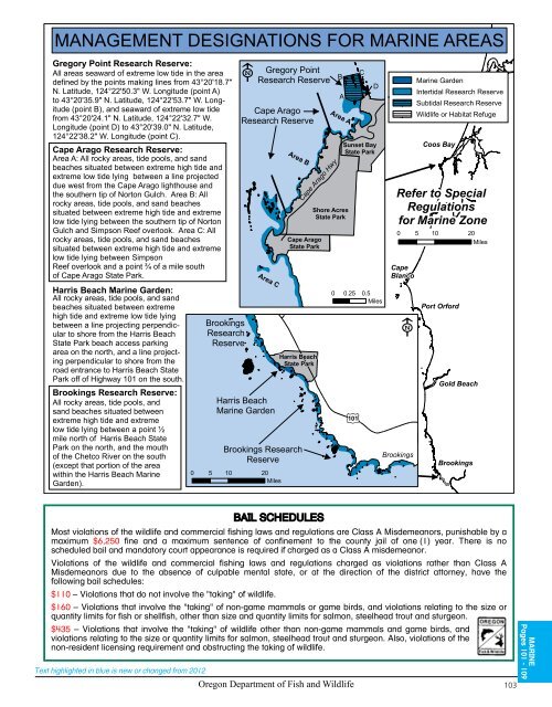
MANAGEMENT DESIGNATIONS FOR MARINE AREAS Gregory Point Research Reserve: All areas seaward of extreme low tide in the area defined by the points making lines from 43°20'18.7" N. Latitude, 124°22'50.3" W. Longitude (point A) to 43°20'35.9" N. Latitude, 124°22'53.7" W. Longitude (point B), and seaward of extreme low tide from 43°20'24.1" N. Latitude, 124°22'32.7" W. Longitude (point D) to 43°20'39.0" N. Latitude, 124°22'38.2" W. Longitude (point C). Cape Arago Research Reserve: Area A: All rocky areas, tide pools, and sand beaches situated between extreme high tide and extreme low tide lying between a line projected due west from the Cape Arago lighthouse and the southern tip of Norton Gulch. Area B: All rocky areas, tide pools, and sand beaches situated between extreme high tide and extreme low tide lying between the southern tip of Norton Gulch and Simpson Reef overlook. Area C: All rocky areas, tide pools, and sand beaches situated between extreme high tide and extreme low tide lying between Simpson Reef overlook and a point ¾ of a mile south of Cape Arago State Park. Harris Beach Marine Garden: All rocky areas, tide pools, and sand beaches situated between extreme high tide and extreme low tide lying between a line projecting perpendicular to shore from the Harris Beach State Park beach access parking area on the north, and a line projecting perpendicular to shore from the road entrance to Harris Beach State Park off of Highway 101 on the south. Brookings Research Reserve: All rocky areas, tide pools, and sand beaches situated between extreme high tide and extreme low tide lying between a point ½ mile north of Harris Beach State Park on the north, and the mouth of the Chetco River on the south (except that portion of the area within the Harris Beach Marine Garden). Text highlighted in blue is new or changed from 2012 Brookings Research Reserve Gregory Point Research Reserve Cape Arago Research Reserve Area C Harris Beach Marine Garden BAIL SCHEDULES Cape Blanco Coos Bay Refer to Special Regulations for Marine Zone Port Orford Gold Beach Brookings Most violations of the wildlife and commercial fishing laws and regulations are Class A Misdemeanors, punishable by a maximum $6,250 fine and a maximum sentence of confinement to the county jail of one (1) year. There is no scheduled bail and mandatory court appearance is required if charged as a Class A misdemeanor. Violations of the wildlife and commercial fishing laws and regulations charged as violations rather than Class A Misdemeanors due to the absence of culpable mental state, or at the direction of the district attorney, have the following bail schedules: $110 – Violations that do not involve the "taking" of wildlife. $160 – Violations that involve the "taking" of non-game mammals or game birds, and violations relating to the size or quantity limits for fish or shellfish, other than size and quantity limits for salmon, steelhead trout and sturgeon. $435 – Violations that involve the "taking" of wildlife other than non-game mammals and game birds, and violations relating to the size or quantity limits for salmon, steelhead trout and sturgeon. Also, violations of the non-resident licensing requirement and obstructing the taking of wildlife. Area B Brookings Research Reserve 0 5 10 20 Miles Cape Arago Hwy Cape Arago State Park Harris Beach State Park B A Area A Shore Acres State Park Oregon Department of Fish and Wildlife 103 C D Sunset Bay State Park 0 0.25 0.5 Miles 101 0 5 10 20 Miles Brookings Marine Garden Intertidal Research Reserve Subtidal Research Reserve Wildlife or Habitat Refuge MARINE Pages 101 - 109
- Page 53 and 54: Water Special Regulations Detroit R
- Page 55 and 56: Water Special Regulations 3. Hendri
- Page 57 and 58: Water Special Regulations 3. North
- Page 59 and 60: Water Special Regulations 4. Hwy 99
- Page 61 and 62: SPONSORED BY Oregon Hunters Associa
- Page 63 and 64: Some Things to Think About. Help Ge
- Page 65 and 66: (541) 553-2002. ek 207 Madras JEFFE
- Page 67 and 68: Species Name Catch Limits Length Li
- Page 69 and 70: Water Special Regulations Fifteenmi
- Page 71 and 72: Stop Harmful Species! Unwanted plan
- Page 73 and 74: $ r gs $ $ endleton P River McKay R
- Page 75 and 76: Special Regulations for This Zone:
- Page 77 and 78: Water Special Regulations Wallowa R
- Page 79 and 80: 206 74 ED IN THIS ZONE. (SEE SNAKE
- Page 81 and 82: Rock Cr Southeast Corner of Southea
- Page 83 and 84: Description: The Southeast Zone is
- Page 85 and 86: Water Special Regulations Deming Cr
- Page 87 and 88: Water Special Regulations Sand Cree
- Page 89 and 90: OREGON DISABILITIES HUNTING AND FIS
- Page 91 and 92: Pine Creek 07 245 Baker 203 Text hi
- Page 93 and 94: Special Regulations for This Zone:
- Page 95 and 96: 0 1 2 3 4 Miles 14 Columbia River Z
- Page 97 and 98: Prairie Channel Minaker Island PACI
- Page 99 and 100: Species Name Catch Limits Length Li
- Page 101 and 102: Water Special Regulations 4. Bonnev
- Page 103: MANAGEMENT DESIGNATIONS FOR MARINE
- Page 107 and 108: Species Name Daily Catch Limits Har
- Page 109 and 110: Area Special Regulations Shellfish
- Page 111 and 112: Clam and Crab Identification A. B.
- Page 113: $ 10 OFF TAKE YOUR NEXT HUNTING, FI
- Page 116: Hank Parker, host of “Hank Parker
MANAGEMENT DESIGNATIONS FOR MARINE AREAS<br />
Gregory Point Research Reserve:<br />
All areas seaward <strong>of</strong> extreme low tide in the area<br />
defined by the points making lines from 43°20'18.7"<br />
N. Latitude, 124°22'50.3" W. Longitude (point A)<br />
to 43°20'35.9" N. Latitude, 124°22'53.7" W. Longitude<br />
(point B), <strong>and</strong> seaward <strong>of</strong> extreme low tide<br />
from 43°20'24.1" N. Latitude, 124°22'32.7" W.<br />
Longitude (point D) to 43°20'39.0" N. Latitude,<br />
124°22'38.2" W. Longitude (point C).<br />
Cape Arago Research Reserve:<br />
Area A: All rocky areas, tide pools, <strong>and</strong> s<strong>and</strong><br />
beaches situated between extreme high tide <strong>and</strong><br />
extreme low tide lying between a line projected<br />
due west from the Cape Arago lighthouse <strong>and</strong><br />
the southern tip <strong>of</strong> Norton Gulch. Area B: All<br />
rocky areas, tide pools, <strong>and</strong> s<strong>and</strong> beaches<br />
situated between extreme high tide <strong>and</strong> extreme<br />
low tide lying between the southern tip <strong>of</strong> Norton<br />
Gulch <strong>and</strong> Simpson Reef overlook. Area C: All<br />
rocky areas, tide pools, <strong>and</strong> s<strong>and</strong> beaches<br />
situated between extreme high tide <strong>and</strong> extreme<br />
low tide lying between Simpson<br />
Reef overlook <strong>and</strong> a point ¾ <strong>of</strong> a mile south<br />
<strong>of</strong> Cape Arago State Park.<br />
Harris Beach Marine Garden:<br />
All rocky areas, tide pools, <strong>and</strong> s<strong>and</strong><br />
beaches situated between extreme<br />
high tide <strong>and</strong> extreme low tide lying<br />
between a line projecting perpendicular<br />
to shore from the Harris Beach<br />
State Park beach access parking<br />
area on the north, <strong>and</strong> a line projecting<br />
perpendicular to shore from the<br />
road entrance to Harris Beach State<br />
Park <strong>of</strong>f <strong>of</strong> Highway 101 on the south.<br />
Brookings Research Reserve:<br />
All rocky areas, tide pools, <strong>and</strong><br />
s<strong>and</strong> beaches situated between<br />
extreme high tide <strong>and</strong> extreme<br />
low tide lying between a point ½<br />
mile north <strong>of</strong> Harris Beach State<br />
Park on the north, <strong>and</strong> the mouth<br />
<strong>of</strong> the Chetco River on the south<br />
(except that portion <strong>of</strong> the area<br />
within the Harris Beach Marine<br />
Garden).<br />
Text highlighted in blue is new or changed from 2012<br />
Brookings<br />
Research<br />
Reserve<br />
Gregory Point<br />
Research Reserve<br />
Cape Arago<br />
Research Reserve<br />
Area C<br />
Harris Beach<br />
Marine Garden<br />
BAIL SCHEDULES<br />
Cape<br />
Blanco<br />
Coos Bay<br />
Refer to Special<br />
Regulations<br />
for Marine Zone<br />
Port Orford<br />
Gold Beach<br />
Brookings<br />
Most violations <strong>of</strong> the wildlife <strong>and</strong> commercial fishing laws <strong>and</strong> regulations are Class A Misdemeanors, punishable by a<br />
maximum $6,250 fine <strong>and</strong> a maximum sentence <strong>of</strong> confinement to the county jail <strong>of</strong> one (1) year. There is no<br />
scheduled bail <strong>and</strong> m<strong>and</strong>atory court appearance is required if charged as a Class A misdemeanor.<br />
Violations <strong>of</strong> the wildlife <strong>and</strong> commercial fishing laws <strong>and</strong> regulations charged as violations rather than Class A<br />
Misdemeanors due to the absence <strong>of</strong> culpable mental state, or at the direction <strong>of</strong> the district attorney, have the<br />
following bail schedules:<br />
$110 – Violations that do not involve the "taking" <strong>of</strong> wildlife.<br />
$160 – Violations that involve the "taking" <strong>of</strong> non-game mammals or game birds, <strong>and</strong> violations relating to the size or<br />
quantity limits for fish or shellfish, other than size <strong>and</strong> quantity limits for salmon, steelhead trout <strong>and</strong> sturgeon.<br />
$435 – Violations that involve the "taking" <strong>of</strong> wildlife other than non-game mammals <strong>and</strong> game birds, <strong>and</strong><br />
violations relating to the size or quantity limits for salmon, steelhead trout <strong>and</strong> sturgeon. Also, violations <strong>of</strong> the<br />
non-resident licensing requirement <strong>and</strong> obstructing the taking <strong>of</strong> wildlife.<br />
Area B<br />
Brookings Research<br />
Reserve<br />
0 5 10 20<br />
Miles<br />
Cape Arago Hwy<br />
Cape Arago<br />
State Park<br />
Harris Beach<br />
State Park<br />
B<br />
A<br />
Area A<br />
Shore Acres<br />
State Park<br />
<strong>Oregon</strong> <strong>Department</strong> <strong>of</strong> <strong>Fish</strong> <strong>and</strong> <strong>Wildlife</strong> 103<br />
C<br />
D<br />
Sunset Bay<br />
State Park<br />
0 0.25 0.5<br />
Miles<br />
101<br />
0 5 10 20<br />
Miles<br />
Brookings<br />
Marine Garden<br />
Intertidal Research Reserve<br />
Subtidal Research Reserve<br />
<strong>Wildlife</strong> or Habitat Refuge<br />
MARINE<br />
Pages 101 - 109


