SPOrT FISHIng regulaTIOnS - Oregon Department of Fish and Wildlife
SPOrT FISHIng regulaTIOnS - Oregon Department of Fish and Wildlife
SPOrT FISHIng regulaTIOnS - Oregon Department of Fish and Wildlife

You also want an ePaper? Increase the reach of your titles
YUMPU automatically turns print PDFs into web optimized ePapers that Google loves.
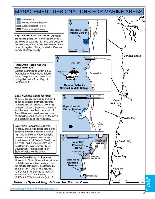
MANAGEMENT DESIGNATIONS FOR MARINE AREAS<br />
Marine Garden<br />
Intertidal Research Reserve<br />
Subtidal Research Reserve<br />
<strong>Wildlife</strong> or Habitat Refuge<br />
Haystack Rock Marine Garden: All rocky<br />
areas, tide pools, <strong>and</strong> s<strong>and</strong> beaches situated<br />
between extreme high tide <strong>and</strong> extreme<br />
low tide lying within a 300 yard radius <strong>of</strong> the<br />
base <strong>of</strong> Haystack Rock, located at Cannon<br />
Beach, Clatsop County.<br />
Three Arch Rocks National<br />
<strong>Wildlife</strong> Refuge:<br />
Boating is prohibited within a 500<br />
foot radius <strong>of</strong> Finley Rock, Middle<br />
Rock, Shag Rock, <strong>and</strong> Seal Rock<br />
during the period from May 1 to<br />
September 15.<br />
Cape Kiw<strong>and</strong>a Marine Garden:<br />
All rocky areas, tide pools, <strong>and</strong> s<strong>and</strong><br />
beaches situated between extreme<br />
high tide <strong>and</strong> extreme low tide lying<br />
between the s<strong>and</strong> beach on the north<br />
<strong>and</strong> the s<strong>and</strong> beach on the south <strong>of</strong><br />
Cape Kiw<strong>and</strong>a. Includes rocky areas<br />
abutting the s<strong>and</strong> beaches on the north<br />
<strong>and</strong> south sides <strong>of</strong> the headl<strong>and</strong>.<br />
Boiler Bay Research Reserve:<br />
All rocky areas, tide pools, <strong>and</strong> s<strong>and</strong><br />
beaches situated between extreme<br />
high tide <strong>and</strong> extreme low tide lying<br />
between a line projected due west<br />
from the mouth <strong>of</strong> Fogarty Creek, on<br />
the north, <strong>and</strong> a line projected due<br />
west from the westernmost tip <strong>of</strong><br />
Government Point at Boiler Bay<br />
State Wayside on the south.<br />
Pirate Cove Research Reserve:<br />
All areas in Pirate Cove below extreme<br />
high tide east <strong>of</strong> a line drawn across<br />
the mouth <strong>of</strong> the cove, as defined by<br />
points at 44°49'05.0" N. Latitude,<br />
124°04'02.1" W. Longitude (point A)<br />
<strong>and</strong> 44°49'08.8" N. Latitude,<br />
124°04'03.6" W. Longitude (point B).<br />
Refer to Special Regulations for Marine Zone<br />
Text highlighted in blue is new or changed from 2012<br />
Shag Rock<br />
Haystack Rock<br />
Marine Garden<br />
0 0.5 1<br />
Miles<br />
Finley Rock<br />
Three Arch Rocks<br />
National <strong>Wildlife</strong> Refuge<br />
Cape Kiw<strong>and</strong>a<br />
Marine Garden<br />
Cannon Beach<br />
101<br />
0 0.5 1<br />
Miles<br />
Oceanside<br />
131<br />
0 0.5 1<br />
Miles<br />
Boiler Bay<br />
Research<br />
Reserve<br />
Government<br />
Point<br />
Pirate Cove<br />
Research<br />
Reserve<br />
B<br />
A<br />
Cape Kiw<strong>and</strong>a Dr<br />
0 0.5 1<br />
Miles<br />
to<br />
Pacific<br />
City<br />
101<br />
Boiler Bay<br />
State Wayside<br />
Depoe Bay<br />
Fogarty Creek<br />
State Park<br />
Cape<br />
Lookout<br />
Astoria<br />
Cannon Beach<br />
Oceanside<br />
Pacific City<br />
Lincoln City<br />
Depoe Bay<br />
Newport<br />
0 5 10 20<br />
Miles<br />
<strong>Oregon</strong> <strong>Department</strong> <strong>of</strong> <strong>Fish</strong> <strong>and</strong> <strong>Wildlife</strong> 101<br />
MARINE<br />
Pages 101 - 109