

TCMA - Texas Cave Management Association
TCMA - Texas Cave Management Association
TCMA - Texas Cave Management Association

Create successful ePaper yourself
Turn your PDF publications into a flip-book with our unique Google optimized e-Paper software.
SUMMER 2009 VOL 10 NO 2<br />
<strong>TCMA</strong>: <strong>Cave</strong>rs Protecting <strong>Cave</strong>s<br />
Twenty-five years ago there was<br />
no organized means of protecting<br />
caves in <strong>Texas</strong>; but around that<br />
time, there was the beginnings of a<br />
push to set aside caves and protect<br />
their wildlife. To this end, cavers<br />
started thinking about a caver-led<br />
organization that would work to<br />
protect caves. An organization<br />
focused on those goals was founded<br />
on April 7, 1986 and was named<br />
the <strong>Texas</strong> <strong>Cave</strong> <strong>Management</strong><br />
<strong>Association</strong> (<strong>TCMA</strong>).<br />
Since then, <strong>TCMA</strong> has grown<br />
to over 150 members and now<br />
owns 12 caves on seven different<br />
preserves, both large and small,<br />
totaling 345 acres and also manages<br />
a number of additional caves under<br />
contracts with the land owners. Over the last ten years,<br />
the organization has seen tremendous growth and has<br />
taken on a stronger focus of saving caves the oldfashioned<br />
way—by buying them. <strong>TCMA</strong>’s emphasis<br />
has been on recreational access for cavers as well as<br />
protection of the caves themselves and the wildlife and<br />
geology contained within. <strong>TCMA</strong>’s largest acquisition<br />
to date is the 225-acre preserve containing Deep and<br />
Punkin <strong>Cave</strong>s and the $125,000 fundraising effort to<br />
pay for it, which is now nearly complete.<br />
A 501(c)3 nonprofit corporation in <strong>Texas</strong>, <strong>TCMA</strong><br />
is also a conservancy of the National Speleological<br />
Society and is affiliated with the Land Trust<br />
Alliance, Bat Conservation International, the <strong>Texas</strong><br />
Speleological <strong>Association</strong>, and other conservation<br />
By Linda Palit and Joe Mitchell<br />
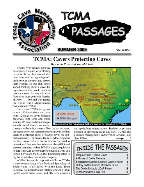
Map showing the Preserves that are owned or managed by <strong>TCMA</strong>.<br />
and speleology organizations. Besides its primary<br />
mission of protecting caves and karst, <strong>TCMA</strong> also<br />
provides management, conservation services, and<br />
See <strong>TCMA</strong> p. 5<br />
Deep & Punkin: Classic <strong>Cave</strong>s 3<br />
A History of Ezell’s Preserve 6<br />
Endangered Species <strong>Cave</strong>s of Godwin Ranch 8<br />
History and Restoration at Robber Baron 10<br />
The Devil’s Sinkhole LIDAR Project 15<br />
<strong>TCMA</strong> President: Linda Palit 16
2<br />
The Passages is the biannual publication of<br />
the <strong>Texas</strong> <strong>Cave</strong> <strong>Management</strong> <strong>Association</strong> (<strong>TCMA</strong>)<br />
meant to bring you news of the organization and its<br />
caves as well as updates on our business affairs. Occasionally<br />
we also print an issue of Passages which<br />
is more general and is meant to be informative and<br />
less time sensitive for publicizing the purpose of<br />
<strong>TCMA</strong>. This issue is such a general issue.<br />
<strong>TCMA</strong> is an all volunteer organization which<br />
depends on the cavers, naturalists, and scientists<br />
who visit, use, and love caves. One of the goals of<br />
<strong>TCMA</strong> is to make sure caves are available for visitation.<br />
Acquisition is one of the best strategies for<br />
ensuring the future availability of access to caves,<br />
and to conserve the caves that now exist.<br />
During the first decade of the 21st Century,<br />
<strong>TCMA</strong> has been successful in acquiring caves. We<br />
have acquired three significant <strong>Texas</strong> classic caves,<br />
Deep <strong>Cave</strong>, Punkin <strong>Cave</strong>, and Ezell’s <strong>Cave</strong>. Building<br />
on this success, we hope to continue raising funds<br />
to acquire new caves and to manage our existing<br />
Preserves.<br />
In <strong>Texas</strong>, more than 95 percent of land is privately<br />
owned. Private landowners have become more<br />
and more hesitant to allow any cavers or scientists<br />
access to their property, and when they do allow access,<br />
it is usually to a very small number of people.<br />
For this reason, acquisition is especially important<br />
in <strong>Texas</strong>. So what does it take to acquire caves?<br />
Unfortunately, many caves are on huge ranches,<br />
and many ranchers will not sell a small portion of<br />
their land separate from the ranch. <strong>TCMA</strong> currently<br />
does not have the millions of dollars it would take to<br />
buy a huge ranch like the one Sorcerer’s <strong>Cave</strong>, the<br />
deepest cave in the state, is on. But it is important<br />
we continue to talk to ranchers, and continue to<br />
Summer 2009<br />
VIEW FROM THE PALIT<br />
By Linda Palit<br />
ICS 2009<br />
<strong>TCMA</strong> is a proud<br />
sponsor of the<br />
15th International<br />
Congress<br />
of Speleology!<br />
<strong>TCMA</strong> PASSAGES<br />
SUMMER 2009<br />
The bi-annual publication of:<br />
<strong>TCMA</strong> Passages<br />
pursue purchases, both to educate the ranchers to the<br />
importance of caves and find the occasional rancher<br />
that will sell his cave on a smaller acreage.<br />
Sometimes subdivisions and commercial developments<br />
contain caves, and these often present different<br />
problems for both purchase and management.<br />
The land the cave is on may be priced at market<br />
value. If the cave is well known or has an important<br />
feature such as headwaters for a creek, the sale price<br />
may be much higher than the surrounding land.<br />
When that is very steep, there is sometimes potential<br />
for discussion of management or of the management<br />
issues of properties with caves that could lead to<br />
easements or management agreements. To be successful<br />
at finding and acquiring these caves takes<br />
cavers watching the market and carefully talking<br />
about the relevant issues with the owners.<br />
<strong>TCMA</strong> needs the support of cavers, scientists<br />
and any others interested in preserving <strong>Texas</strong> <strong>Cave</strong><br />
Resources. Support can be monetary or can be labor,<br />
because there is always more work to be done both to<br />
acquire and to take care of caves. Continued growth<br />
in the next decade will mean acquiring more caves<br />
for exploration, research, enjoyment and education.<br />
We all can contribute to this, and make more <strong>Texas</strong><br />
<strong>Cave</strong>s open to visitation.<br />
Vol. 10 No. 2<br />
The <strong>Texas</strong> <strong>Cave</strong> <strong>Management</strong> <strong>Association</strong><br />
PO Box 7427<br />
Austin, <strong>Texas</strong>, 78713<br />
www.tcmacaves.org<br />
Editor:<br />
Joe Mitchell<br />
11463 Enchanted Sunset Dr.<br />
San Antonio, TX 78253<br />
E-mail: joemitchell@satx.rr.com
<strong>TCMA</strong> Passages Summer 2009<br />
Deep & Punkin <strong>Cave</strong>s: Two <strong>Texas</strong> Classics<br />
By Geary Schindel<br />
For those of you who are new to<br />
<strong>Texas</strong> caving, the <strong>Texas</strong> <strong>Cave</strong> <strong>Management</strong><br />
<strong>Association</strong> purchased the<br />
Deep and Punkin Nature Preserve in<br />
October 2004 for cavers. This preserve<br />
is comprised of 225 acres of<br />
prime Edwards Plateau/<strong>Texas</strong> Hill<br />
Country land in Edwards County,<br />
<strong>Texas</strong>. The purchase of the property<br />
was made possible by the incredible<br />
and generous support of the <strong>Texas</strong><br />
caving community. The property was<br />
purchased for $128,900 with a 15<br />
year note. It looks like we are on target<br />
to pay off the loan this summer at<br />
the International Congress of Speleology<br />
– ten years early.<br />
Since the purchase of the property,<br />
cavers have worked hard on clearing<br />
campsites, cleaning up and repairing the cabin,<br />
fighting wild fires, and mapping and exploring both<br />
Deep and Punkin caves. The Deep <strong>Cave</strong> mapping<br />
project is being managed by Jerry Atkinson and is<br />
currently 2.548 kilometers long and 77.6 meters<br />
deep. Mapping is still continuing in the cave and<br />
we expect at least another kilometer of passage. The<br />
Punkin <strong>Cave</strong> project is being managed by Jim Kennedy.<br />
The current length of mapped cave is 1.826<br />
kilometer and depth is 63 meters. When the property<br />
was purchased, Punkin was considered a relatively<br />
small cave containing a scenic entrance pit<br />
and room. Mapping of the cave has shown Punkin<br />
to be an extensive cave in its own right. The wind<br />
in Punkin <strong>Cave</strong> hints at a lot more cave to be found.<br />
Both Deep and Punkin contain virgin leads.<br />
There have been a number of trips to the Deep<br />
and Punkin Nature Preserve this winter and spring.<br />
There was one mapping trip lead by Jim Kennedy<br />
to Punkin <strong>Cave</strong> and a number of recreational and<br />
work trips. One of the major accomplishments on<br />
the property were the opening for business of the<br />
ELoo desiccating toilet system in the fall of 2008.<br />
The system seems to be working and is well suited<br />
See DEEP & PUNKIN p. 4<br />
The Forest of Columns in Deep <strong>Cave</strong>.<br />
Photo by Dave Bunnell<br />
Deep & Punkin Preserve<br />
Location: Western Edwards County<br />
Year acquired: 2004<br />
Property size: 225 acres<br />
<strong>Cave</strong>s: Deep <strong>Cave</strong>, Punkin <strong>Cave</strong><br />
Significance: Two major, classic <strong>Texas</strong> caves;<br />
Deep <strong>Cave</strong> highly decorated; Large bat population<br />
in Punkin <strong>Cave</strong>; H 2 S origin probable.<br />
Description: Deep and Punkin are located in a<br />
remote area of west-central <strong>Texas</strong> in the Carta<br />
Valley amid large ranches. Both are interesting,<br />
complex, multi-level caves. Deep <strong>Cave</strong> is quite<br />
extensive with over 2.5 km surveyed and continues<br />
to reveal major new passage. The cave<br />
contains vertical sections and highly decorated<br />
sections including the Forest of Columns<br />
and Helictite Room. Punkin <strong>Cave</strong> has a 14 m<br />
free-drop pit entrance into a large bat chamber<br />
that leads to more than 1.8 km of mapped<br />
cave. Many leads remain to be explored. This<br />
is a very popular caving destination and has a<br />
cabin that can sleep more than a dozen people.<br />
Since acquisition, there have been numerous<br />
work projects to improve the property, renovate<br />
the cabin, and continue exploration and survey<br />
of the caves.
DEEP & PUNKIN (from p. 3)<br />
for the hot, dry, windy days in west <strong>Texas</strong>. There is<br />
still some detailing work that needs to be completed<br />
to bring the toilet system up to snuff. However, it<br />
has a roof, door, walls, and a seat with a great view.<br />
As the wind blows, it pulls quite a vacuum down<br />
the toilet stand pipe so the user has to be careful<br />
of not creating too tight a seal. To prevent accidents,<br />
we’ve also left a shoe horn within reach to<br />
break a seal. The ELoo was made possible by the<br />
hard work of a number of people including Venture<br />
Crew 410 who poured the concrete slab, helped to<br />
erect the support posts and walls and rafters. Carl<br />
Pobnabchek also made a generous donation for the<br />
purchase of the ELoo and was awarded the naming<br />
rights. From now on, the ELoo will go by the<br />
name “Carl’s Comfortable Crapper and Loo with<br />
a View” or CCC&LWAV. <strong>Cave</strong>rs will find the<br />
CCC&LWAV a great improvement over the pickle<br />
bucket.<br />
The biggest work project at the property has<br />
been the back porch. Work began on erecting a<br />
two story structure over the back porch to provide<br />
cover and an additional sleeping area on the property.<br />
This 16 by 20 foot steel structure has been<br />
slowly growing with the installation of the foundations,<br />
erection of steel columns and beams, and the<br />
placement of the joists and decking. Most of the<br />
steel work was completed by Lex Cox and Milo<br />
Mills from the Cow Town Grotto with help from<br />
Zach and Justin Olsen from Venture Crew 410 in<br />
Summer 2009<br />
<strong>TCMA</strong> Passages<br />
Photo by Geary Schindel<br />
The two story back porch, under construction behind<br />
the field house, will provide shade, sleeping<br />
space and great views.<br />
San Antonio and Lydia Hernandez from Austin.<br />
The steel work began on Memorial Day 2008 and<br />
has progressed over the year. On Memorial Day<br />
, 2009, Lex and Milo returned with a crew to install<br />
a roof system donated by Mueller Building<br />
Company. To complete the project, we will need<br />
to install some additional bracing, a railing, and<br />
stairs but hopefully, the project will be completed<br />
this fall. We hope to install an additional stove and<br />
refrigerator and other cooking items to the back<br />
porch. This will improve our ability to accommodate<br />
large group cooking at the site.<br />
Photo by Dave Bunnell<br />
The entrance room of Punkin <strong>Cave</strong> with the 1 m drop at right and the 6 m drop at left.
<strong>TCMA</strong> Passages Summer 2009<br />
Photo by Geary Schindel<br />
A double rainbow stands over Deep & Punkin Preserve.<br />
<strong>TCMA</strong> (from p. 1)<br />
educational information to individuals, organizations,<br />
and governmental agencies. Our caves are routinely<br />
used by cavers, youth groups, rescue training groups,<br />
and other interested organizations.<br />
<strong>TCMA</strong>’s first acquisition was Whirlpool <strong>Cave</strong><br />
Preserve (4.25 acres) in 1990; <strong>TCMA</strong> raised money<br />
to pay off the back taxes, after which the owner<br />
deeded the cave to <strong>TCMA</strong>. This was the first cave<br />
to be owned by a caving organization in <strong>Texas</strong>.<br />
Whirlpool has been used by the City of Austin,<br />
the University of <strong>Texas</strong> Speleological Society and<br />
other groups on a regular basis for beginner trips.<br />
Additional caves and properties have been acquired<br />
over the years, bringing the number of preserves to<br />
seven, and the organization continues to actively<br />
search for new caves. <strong>TCMA</strong> manages several other<br />
caves including those on the University of <strong>Texas</strong><br />
properties; 0-9 Well and Amazing Maze caves in<br />
west <strong>Texas</strong>.<br />
Sponsoring cleanup in caves and sinkholes and<br />
participating in the restoration and evaluation of<br />
caves and properties for landowners are additional<br />
<strong>TCMA</strong> activities. <strong>Management</strong> is also contracted<br />
on caves for other entities consisting of fire ant<br />
monitoring and control, gating, documentation of<br />
cave flora and fauna, and assorted other activities.<br />
The sites of some of these caves do not generally<br />
allow visitation, and are on government or private<br />
property. <strong>TCMA</strong> is also involved in educating the<br />
public about caves and cave lands, especially using<br />
the caves for education of small schools, universities,<br />
or neighborhood groups. Through <strong>TCMA</strong>’s<br />
efforts thousands of school children and the public<br />
We’ve made substantial improvements to<br />
the water system at the cabin. We added 1,200<br />
gallons of storage with an additional poly tank<br />
and plumbed the new tank into the existing<br />
water system. Lex and Milo installed a gutter<br />
system on the new roof of the back porch<br />
which should greatly increase the amount of<br />
water available at the site. We’ve also installed<br />
a new pressure pump to provide water<br />
to the sink and shower system.<br />
We’ve had a number of recreational and<br />
photographic trips to both caves by various<br />
grottos, university outing clubs, BSA Venture<br />
Crews, and others. <strong>Texas</strong> cavers now have two<br />
first rate caves and a first rate field house.<br />
have been exposed to caves in their natural state<br />
and have learned about cave conservation and safety.<br />
All activities are performed by volunteers, so<br />
the scope of activities can be limited.<br />
Through their work in Central <strong>Texas</strong>, <strong>TCMA</strong> has<br />
become a significant player in the environmental<br />
and conservation community, helping to implement<br />
tougher regulations against groundwater pollution<br />
in Travis County, working with land developers and<br />
others to set aside adequate recharge zones to protect<br />
caves and aquifers, urging more stringent safeguards<br />
in Bexar County and working with local, state and<br />
federal agencies in furtherance of these and other<br />
related goals. Over the years, <strong>TCMA</strong> has received a<br />
number of accolades, including the Environmental<br />
Education Award from the Barton Springs-Edwards<br />
Aquifer Conservation District.<br />
Scientific research is also supported by <strong>TCMA</strong><br />
when possible. Currently <strong>TCMA</strong> has several air<br />
monitoring projects at Robber Baron <strong>Cave</strong>. <strong>TCMA</strong><br />
and the San Marcos River Foundation conduct water<br />
level and water chemistry monitoring at Ezell’s<br />
<strong>Cave</strong>. With other partners, <strong>TCMA</strong> coordinated a<br />
LIDAR mapping project at the Devil’s Sinkhole<br />
State Natural Area.<br />
As <strong>TCMA</strong> looks toward the future, it now has<br />
to begin to balance the transition from a small<br />
organization to a larger and more complex one. One<br />
discussion in recent years has involved hiring an<br />
Executive Director to managed either grant writing or<br />
the day-to-day operations. Whatever happens in the<br />
future, the basic goals of the organization will remain:<br />
protecting <strong>Texas</strong> <strong>Cave</strong>s for <strong>Texas</strong> <strong>Cave</strong>rs.
6<br />
Summer 2009<br />
Ezell’s <strong>Cave</strong>: Home of the Blind Monster<br />
By Allan B. Cobb<br />
Ezell’s <strong>Cave</strong> is one of <strong>Texas</strong><br />
<strong>Cave</strong> <strong>Management</strong> <strong>Association</strong>’s<br />
(<strong>TCMA</strong>) <strong>Cave</strong> Preserves located<br />
in Hays County, <strong>Texas</strong> and has the<br />
distinction of being the first cave<br />
preserve in <strong>Texas</strong> established by<br />
The Nature Conservancy in 1967.<br />
<strong>TCMA</strong> acquired the cave from The<br />
Nature Conservancy in 2004. The<br />
Edwards Aquifer Authority holds a<br />
Conservation Easement on the cave.<br />
The preserve is managed by <strong>TCMA</strong><br />
Director, Jon Cradit.<br />
Ezell’s <strong>Cave</strong> is a rich biological<br />
cave and home to about 100 different<br />
species, some of which are rare or<br />
endangered. One of the endangered<br />
species in the cave is the <strong>Texas</strong> Blind Salamander,<br />
Eurycea rathbuni. The <strong>Texas</strong> Blind salamander is<br />
white in color because it lacks pigment. It has two<br />
small bluish dots where its eyes once were.<br />
The <strong>Texas</strong> Blind Salamander was included with<br />
the first group of animals designated as endangered<br />
Ezell’s Preserve<br />
Location: South side of San Marcos<br />
Year acquired: 2004<br />
Property size: 2 acres<br />
<strong>Cave</strong>s: Ezell's <strong>Cave</strong><br />
Significance: Diverse and extensive community<br />
of cave fauna; Home to <strong>Texas</strong> Blind<br />
Salamander; Direct access to the Edwards<br />
Aquifer; National Natural Landmark.<br />
Description: Ezell's <strong>Cave</strong> is located in a residential<br />
neighborhood. The cave is not extensive<br />
with only 80 m of un-submerged Passage,<br />
but contains an important and delicate ecosystem<br />
of nearly 100 rare and endangered subterranean<br />
species. With its direct access to the<br />
aquifer, the cave is an important scientific resource.<br />
Visitation to the cave is kept restricted<br />
to protect it.<br />
The <strong>Texas</strong> Blind Salamander found in Ezell’s <strong>Cave</strong>.<br />
<strong>TCMA</strong> Passages<br />
Photo by Allan B. Cobb<br />
species in 1973. The first specimens were collected<br />
from Ezell’s <strong>Cave</strong> and later from a nearby artesian<br />
well. The species was described in 1895 and is still<br />
considered one of the most highly cave-adapted<br />
animals.<br />
Ezell’s <strong>Cave</strong> was discovered in 1870 by Greenberry<br />
Ezell. The cave was not on his land but he<br />
bought the cave and one acre of land and operated<br />
the cave commercially for several years. Part of<br />
the attraction of the cave was the lake at the bottom<br />
containing many strange and unusual creatures<br />
swimming about. Tourists were rowed around the<br />
small lake in a small boat.<br />
In 1955, the <strong>Texas</strong> Herpetological Society purchased<br />
the cave to protect it. The cave was vandalized<br />
and many of the unique species in the cave<br />
were taken for the rare animal trade. The cave was<br />
sold and the entrance was sealed in 1962 to prevent<br />
further vandalism. In 1967, The Nature Conservancy<br />
bought the cave with the help of the Southwest <strong>Texas</strong><br />
Grotto and reopened the entrance.<br />
In 1972, the cave was designated as a National<br />
Natural Landmark by the National Park Service. In<br />
2004, The Nature Conservancy transferred ownership<br />
of the cave and about 3 acres around the
<strong>TCMA</strong> Passages Summer 2009<br />
cave to <strong>TCMA</strong>. The Nature Conservancy gave a<br />
Conservation Easement on the cave to the Edwards<br />
Aquifer Authority to ensure that it is maintained in<br />
a satisfactory manner.<br />
<strong>TCMA</strong> has expanded the research in the cave<br />
with help from the San Marcos River Foundation<br />
and the Edwards Aquifer Authority. Equipment in<br />
the cave monitors water levels and water chemistry<br />
parameters with an automated<br />
system. Results are periodically<br />
uploaded to the Edwards<br />
Aquifer Authority via phone<br />
line.<br />
Ezell’s <strong>Cave</strong> is a direct<br />
window into the Edwards<br />
Aquifer and many of the<br />
unique organisms that live<br />
there. The lake in the cave is<br />
subject to water level changes<br />
from pumping and increased<br />
levels from recharge. In 1992,<br />
high water levels destabilized<br />
portions of the cave causing<br />
rock falls and separation of the<br />
walls in several places.<br />
Because the cave is a sensitive habitat and is<br />
rather unstable, visitation to the cave is limited. To<br />
learn more about the cave, an award-winning documentary<br />
was filmed about the cave. The documentary,<br />
Edwards Aquifer, Ezell’s <strong>Cave</strong>, and Searching<br />
for the Blind Monster by Joe Furman, takes viewers<br />
into the cave and into the lake to see the creatures<br />
living in the cave.<br />
Equipment for continuous water monitoring in Ezell’s <strong>Cave</strong>.
The Godwin Ranch Preserve is a 105 acre<br />
tract in Williamson County that contains three<br />
known caves and several other karst features.<br />
Temples of Thor is the largest cave on the tract.<br />
A smaller cave called Red Crevice <strong>Cave</strong> was recently<br />
surveyed and mapped by <strong>TCMA</strong> staff (see<br />
map below). The caves on the Godwin Ranch<br />
Tract site contain endangered and threatened invertebrates<br />
and include Texella reyesi, Cambala<br />
speobia speobia, a pseudoscorpion: Tartarocreagris<br />
sp., Eidmanella pallida, Vaejovis reddelli,<br />
and blind Cicurina spiders.<br />
Biological monitoring has been performed<br />
monthly on this site as part of the Habitat Conservation<br />
Plan requirements. In addition to species<br />
monitoring within the caves, an annual summer<br />
cricket exit survey is performed. The cricket<br />
count exit surveys are now being performed by<br />
<strong>TCMA</strong> volunteers. If you are interested volun-<br />
Summer 2009<br />
<strong>TCMA</strong> Passages<br />
Godwin Ranch: Habitat for Endangered Species<br />
By Aimee Beveridge<br />
Photo by William Russell<br />
Aimee Beveridge in the entrance to Red Crevice<br />
<strong>Cave</strong> on Godwin Ranch Preserve.<br />
teering with the cricket counts, please contact<br />
Aimee Beveridge aimbev@sbcglobal.net.<br />
Godwin Ranch Preserve<br />
Location: Northwest edge of Georgetown<br />
Year acquired: 2003<br />
Property size: 105 acres<br />
<strong>Cave</strong>s: Thor <strong>Cave</strong>, Red Crevice <strong>Cave</strong><br />
Significance: Endangered species.<br />
Description: Located at the fringe of the<br />
Georgetown urban area, this property is primarily<br />
for protection of endangered species found<br />
in Thor <strong>Cave</strong>. Thor <strong>Cave</strong> is moderately small<br />
cave while Red Crevice is very small. Visitation<br />
is infrequent.
<strong>TCMA</strong> Passages Summer 2009<br />
Rolling Oaks: A Small Preserve Protecting Small Creatures<br />
By Evelynn Mitchell<br />
The Rolling Oaks <strong>Cave</strong> Preserve is a property<br />
on the west side of San Antonio that is home to four<br />
different caves. These caves, World Newt <strong>Cave</strong>,<br />
Chimney Cricket <strong>Cave</strong>, Niche <strong>Cave</strong> and Obvious<br />
Little <strong>Cave</strong>, are located in the Upper Cretaceous<br />
Austin Chalk, but are relatively small compared<br />
to others in the same formation. The entrance to<br />
World Newt <strong>Cave</strong> is a 2 m by 0.8 m crack that drops<br />
1.2 m before yielding a low crawl and a 6.3 m pit.<br />
Chimney Cricket is a series of small offset pits,<br />
with a total depth of 6.1 meters. Niche <strong>Cave</strong> is a 5<br />
m in diameter trash filled sink with a 0.5 m entrance<br />
in the west wall, which goes 8 m into the ground.<br />
Obvious Little <strong>Cave</strong> is another small feature with a<br />
series of offset chimney style pits. The significance<br />
of this preserve is therefore not in the size of its<br />
karst features, but as a home to different species of<br />
endangered cave fauna.<br />
The species found in the caves include various<br />
spiders (a blind species was also identified), cave<br />
crickets, harvestmen, and Rhadine beetles. The<br />
property was acquired by <strong>TCMA</strong> in 2003, at a time<br />
when property in the subdivision was in a development<br />
phase. Acquiring the property to protect it from<br />
development was considered the most important<br />
step in protection of the species. The documentation<br />
of most of these species took place in the early<br />
1980s, and so <strong>TCMA</strong> has decided that the next step<br />
in understanding these delicate ecosystems will be<br />
Rolling Oaks Preserve<br />
Location: Far west side of San Antonio<br />
Year acquired: 2003<br />
Property size: 5.0 acres<br />
<strong>Cave</strong>s: Obvious Little <strong>Cave</strong>, World Newt<br />
<strong>Cave</strong>, Chimney Cricket <strong>Cave</strong>, Niche <strong>Cave</strong><br />
Significance: Endangered species.<br />
Description: This preserve is in a low density<br />
residential neighborhood outside of the city. All<br />
the caves on the property are very small and<br />
one is closed due to trash fill in its entrance.<br />
The property was acquired from the US Marshals<br />
Service who had seized the property.<br />
Visitation is rare.<br />
9<br />
Photo by Kevin McGowan<br />
Jon Cradit climbing into Chimney Cricket <strong>Cave</strong>.<br />
to re-survey the caves to determine the number of<br />
species and the count of each endangered population.<br />
A biological survey has been planned to take<br />
place in the fall of 2009, and from the results of this<br />
study, a monitoring and conservation plan for each<br />
of the caves can be developed. In <strong>Texas</strong>, fire ants<br />
can also be a problem for the survival of cave fauna,<br />
so an assessment of the fire ant populations on the<br />
property must be performed.<br />
Establishment of biological protocols is the biggest<br />
priority at Rolling Oaks right now, but future<br />
projects are also under consideration. The biological<br />
study will lay the groundwork for placing a conservation<br />
easement on the property to protect it from<br />
future development. Additional fencing is planned<br />
for protection from trespassers, and depending on<br />
the results of the biological survey, gates may need<br />
to be added to some of the caves. Another project<br />
will include removing the trash from the Niche <strong>Cave</strong><br />
sink to see if more cave passage can be found.<br />
Although the Rolling Oaks Preserve is a small<br />
property compared to some of <strong>TCMA</strong>’s other properties,<br />
its biological significance is clear and meets<br />
the goal of <strong>TCMA</strong> to protect and conserve caves and<br />
their residents. There is still a lot to accomplish at<br />
this small preserve.
10<br />
Summer 2009<br />
<strong>TCMA</strong> Passages<br />
Robber Baron: History, Mystery, and Restoration<br />
By Joe Mitchell<br />
One of <strong>TCMA</strong>’s most unique<br />
caves is Robber Baron. Not only is<br />
it the longest known cave in San Antonio,<br />
but it has a long and colorful<br />
history and many interesting features<br />
including a large sinkhole entrance,<br />
a complex two-dimensional maze<br />
of passages, and two unique endangered<br />
species. It has also been the<br />
focus of a major restoration project<br />
by <strong>TCMA</strong> over the last several<br />
years. The cave has seen continued<br />
exploration, an updated survey, and<br />
scientific research. Robber Baron is<br />
very popular, with visitation by several<br />
hundred cavers and their guests<br />
per year. Because the cave is so well<br />
known by the general public and in<br />
a densely populated urban environment, it presents<br />
some unique challenges with respect to visitation<br />
and the potential for vandalism.<br />
The cave has been well known since the 1800’s<br />
due to its location along the King’s Highway and<br />
in the early 20th century was known as North Loop<br />
Robber Baron Preserve<br />
Location: Near-north side of San Antonio<br />
Year acquired: 1995<br />
Property size: 0.37 acre lot<br />
<strong>Cave</strong>s: Robber Baron <strong>Cave</strong><br />
Significance: Longest cave in Bexar County;<br />
Historical commercial cave, Extensive maze<br />
cave; Endangered species.<br />
Description: Robber Baron Preserve is located<br />
in a densely populated residential neighborhood<br />
along a major street. The cave has a long<br />
history and was once a commercial cave. It is<br />
heavily visited and is suitable for a wide range<br />
of abilities including new cavers and children.<br />
The cave is an extensive maze of more than 1.5<br />
km of passages that is entered from the bottom<br />
of a deep surface sinkhole. The Preserve recently<br />
completed a major project to restore the<br />
sinkhole and surface while making the property<br />
more attractive.<br />
Photo by James Jasek<br />
As a maze cave, Robber Baron has many interconnecting passages.<br />
Over the years, portions have been heavily vandalized with graffiti.<br />
<strong>Cave</strong>. In 1924, it was opened as a commercial cave<br />
and renamed Robber Baron and over the next nineyears<br />
had an estimated 300,000 visitors. It was the<br />
site of a speakeasy during prohibition and many<br />
social events during that time including dances,<br />
sorority functions, sporting events, and even radio<br />
demonstrations. Portions of the cave were lighted<br />
and during the 50¢ tour, visitors were regaled with<br />
tales of dangerous robbers hiding out in the caves,<br />
lost treasures, and Indian massacres. All of these<br />
stories, along with the cave’s name were invented<br />
to heighten the mystery of the cave.<br />
In the early 1930’s the cave was closed, probably<br />
due to decreased tourism resulting from the worsening<br />
Great Depression. Over the next 40 years, the<br />
cave was wide open and became a popular hang out<br />
for neighborhood youths as well as a public dump.<br />
The interior of the cave became highly vandalized<br />
with graffiti and carvings. The debris in the sinkhole<br />
would alternately plug the entrance and wash open,<br />
on at least one occasion prompting a rescue when<br />
kids became trapped in the cave.<br />
In the late 1970’s, the San Antonio Grotto<br />
became involved in the cave. They conducted a<br />
thorough survey of the cave and performed a major<br />
cleanup of the sinkhole in the 1980’s. The first of<br />
several gates were constructed by grotto members
<strong>TCMA</strong> Passages Summer 2009<br />
and installed at the entrance. Over the years, these<br />
gates were successively breached by determined<br />
kids until a large concrete bunker-style gate was<br />
constructed around 1990.<br />
The lot immediately around the cave was held<br />
back when the area was developed in the 1950’s.<br />
The developer had on occasion vacillated between<br />
wanting to seal the cave and expand it. Finally in<br />
recognition of the years of effort put in to maintain<br />
the property by local cavers, he donated the lot<br />
containing the cave to <strong>TCMA</strong> in 1995. By this time<br />
however, the property, which was now located in<br />
the middle of a residential neighborhood along a<br />
busy street, had taken on the appearance of a long<br />
neglected overgrown vacant lot.<br />
In the early 1990’s, two invertebrate troglobite<br />
species found only in the cave, the Cicurina baronia,<br />
(Robber Baron <strong>Cave</strong> Spider) and the Texella<br />
cokendolpheri (Robber Baron <strong>Cave</strong> Harvestman),<br />
were federally listed as endangered. Both are small,<br />
eyeless, and un-pigmented with long legs. One area<br />
of the cave where the spiders are often seen has been<br />
Tourists in the “Devil’s Kitchen” in the late 1920’s.<br />
This was one of the features of the cave during its<br />
commercial period and contained a fake skeleton<br />
and coffin illuminated by red lights.<br />
11<br />
marked off to provide<br />
an area where they<br />
will not be disturbed.<br />
After the listing<br />
of the two endangered<br />
species in the<br />
cave, <strong>TCMA</strong> and the<br />
Bexar Grotto undertook<br />
a major restoration<br />
project to improve<br />
and protect the<br />
property. The project<br />
was also spurred by<br />
erosion of the fill on<br />
which the entrance<br />
bunker rested. The<br />
goals of the project were: restoring the sinkhole to<br />
a more natural state by digging out decades of accumulated<br />
trash and fill, improving nutrient flow<br />
into the cave by enlarging the entrances and controlling<br />
water flow, building a more ecologically<br />
friendly gate, removing the overgrown vegetation<br />
and non-native species from the property, and creating<br />
a more inviting park-like environment for the<br />
neighborhood.<br />
The project kicked off in 2003 and took five<br />
years to complete. The initial two years of the project<br />
were focused on digging the trash and fill out of<br />
the sinkhole. Using heavy equipment, a trench was<br />
dug into the sinkhole to provide an access ramp.<br />
Although this work was hampered by an extended<br />
period of rainy weather, over 430 m3 Photo by Jean Krejca<br />
Robber Baron <strong>Cave</strong> Spider.<br />
of trash and<br />
fill material was removed. This first phase of the<br />
project was completed when the old bunker gate<br />
was demolished and a new wildlife-friendly gate<br />
was installed. At the same time, the historical second<br />
entrance to the cave was uncovered and gated<br />
to improve air flow.<br />
The second phase of the project involved surface<br />
improvements. The sloping trench was converted<br />
to a series of steps, not only to make it safer<br />
to enter the sinkhole, but also to control water flow<br />
and reduce sediment deposition into the cave. A retaining<br />
wall was also constructed in the sinkhole<br />
for erosion control.<br />
On the surface, significant improvements were<br />
made. A decorative wrought-iron fence was built<br />
See ROBBER BARON p. 12
12<br />
ROBBER BARON (from p. 11)<br />
along the street and other fences were replaced. A<br />
trail across the property, linked by a bridge over<br />
the trench, provides a walking path with views into<br />
the sinkhole. New topsoil was spread, the property<br />
re-graded and other features constructed to<br />
prevent contaminated rainwater from the adjacent<br />
streets from running into<br />
the sinkhole. A landscaping<br />
plan was established,<br />
planting beds prepared,<br />
and native vegetation<br />
planted, giving the property<br />
a more park-like appearance.<br />
Finally a picnic<br />
table was built and an information<br />
kiosk designed<br />
and installed, on which<br />
visitors can read about<br />
Robber Baron, caves, and<br />
<strong>TCMA</strong>.<br />
Throughout the project, over 3700 hours of<br />
work were contributed by more than 275 volunteers.<br />
Eagle Scouts took on several significant<br />
tasks with six Eagle Projects being carried out.<br />
Project expenses have totaled more than $35,000,<br />
much of it in the form of individual donations and<br />
grants. Thanks to the efforts of the volunteers and<br />
contributors, the Preserve is now a<br />
resource for both <strong>TCMA</strong> and the<br />
local neighborhood. People come<br />
by the property on a daily basis<br />
to take a break amongst the shade<br />
trees, read the information about<br />
the cave, or walk down into the<br />
sinkhole to peer in the entrance.<br />
One of the true mysteries of<br />
Robber Baron is that of the “missing”<br />
portions of the cave, with<br />
many stories describing it as much<br />
more extensive than is presently<br />
known. Early visitors told of trav-<br />
eling for hours through the cave<br />
and finding underground lakes,<br />
streams, blind fish, a lower level, and windmill<br />
pipes from the surface. It was also said to connect<br />
to another known nearby cave. George Veni, who<br />
Summer 2009<br />
<strong>TCMA</strong> Passages<br />
helped survey the cave in the 1970’s, has estimated<br />
that the cave could easily have a length of ten miles<br />
or more. However, during the cave’s commercial<br />
period, several passages were blocked off to prevent<br />
people from getting lost or from coming in<br />
via another entrance. There have been a number of<br />
attempts over the years to find the lost portions of<br />
the cave, but these have only resulted in the discov-<br />
Photo by George Veni ery a a few hundred more<br />
meters of passage. In the<br />
last year, digging efforts<br />
have resumed with only<br />
some small new discoveries<br />
made, but the airflow<br />
present throughout<br />
the cave continues to hint<br />
at more to be found.<br />
Recently, the original<br />
survey notes were rediscovered,<br />
having been lost<br />
since the 1970’s and that<br />
Demolishing the old bunker entrance.<br />
data entered into Walls to<br />
produce a modern digital map of the cave. In the<br />
process, several portions of the survey were found<br />
to be inaccurate. Additionally, several recent discoveries<br />
had not yet been surveyed. Several trips<br />
over the last year have focused on cleaning up<br />
these loose ends and now a complete re-drafting of<br />
the cave map is in progress.<br />
Photo by George Veni<br />
The cave’s long history is still<br />
incompletely known with many<br />
stories and tales surrounding it.<br />
In February, a special tour was<br />
given to a man who visited the<br />
cave in the 1930’s and was able to<br />
relate many of his memories. He<br />
told of travelling for an entire day<br />
through the cave and coming to a<br />
place where they could hear flowing<br />
water and gave hints about<br />
the direction they may have gone.<br />
Now in his 80’s, he thoroughly<br />
enjoyed his trip, even crawling<br />
into some tight areas to check<br />
Rick Corbell at the new gate. them out.<br />
Also recently uncovered were a set of articles<br />
from the 1920’s-50’s which provide a great deal<br />
of new information about the history of the cave
<strong>TCMA</strong> Passages Summer 2009<br />
through its commercial period,<br />
showing it as a popular and<br />
well-known local destination.<br />
Some of the articles contained<br />
photos of the cave showing<br />
how it has changed and a previously<br />
unknown 1921 map<br />
that provides some tantalizing<br />
hints about additional portions<br />
of the cave.<br />
A scientific research program<br />
is currently underway in<br />
conjunction with St. Mary’s<br />
University to study the meteorology<br />
of the cave. Robber<br />
Baron has long been known<br />
for its occasional high levels<br />
of CO 2 , and the purpose of the<br />
project is to study the causes<br />
as well as the reasons for the<br />
wide variation in conditions in<br />
the cave ranging from normal<br />
air to very poor conditions.<br />
Furthermore, the cave occasionally<br />
exhibits strong airflow<br />
in certain places which appears<br />
to indicate that the CO 2 is com-<br />
Photo by Kevin McGowan<br />
The restored sinkhole entrance to the cave seen during the 200 open<br />
house. The main entrance is visible at bottom center.<br />
1<br />
ing up from mostly unknown<br />
lower levels and perhaps is<br />
related to dissolution of the<br />
rock by the underlying Edwards<br />
Aquifer. Supporting a<br />
possible aquifer connection<br />
is that Robber Baron is now<br />
thought to have a hypogene<br />
origin where rising groundwater<br />
spread out creating the<br />
maze of passages seen today.<br />
The sinkhole entrance may<br />
have been a paleospring of the<br />
aquifer.<br />
Besides caver visits, the<br />
cave is frequently used for<br />
trips for special groups such as<br />
scouts, conservation groups,<br />
or geology clubs. Numerous<br />
requests are received for<br />
See RBC p. 18
1<br />
Exploration and survey in both Deep and Punkin<br />
caves has continued over the last year. Deep <strong>Cave</strong><br />
closely resembles many of the Guadalupe area caves<br />
in New Mexico in that it is developed as a series of<br />
horizontal maze levels connected by steeply dipping<br />
to vertical rifts. Boneyard mazes are common<br />
and there is abundant evidence of condensation<br />
corrosion. Phreatic pendants and embayments,<br />
rim vents, and cupolas are ubiquitous. During the<br />
last year, Deep <strong>Cave</strong> was pushed in the Aragamilk<br />
Maze area, a complex 3-D maze near the Crystal<br />
Waterfall that is well decorated with both moonmilk<br />
and aragonite. Passages tend to alternate between<br />
tight, crystal-lined crawls and spacious rooms with<br />
multiple leads. Each trip pushed the boundary of the<br />
cave into new areas with numerous leads that blow<br />
air. The present length of the cave is 2730.4 m (8958<br />
feet) with a depth of 77.6 m<br />
(255 feet).<br />
Punkin cave is a 3-D<br />
maze cave with two vertical<br />
entrances that drops into the<br />
huge Entrance Room, a large<br />
collapse chamber well-lit by<br />
daylight. From there, a widesloping<br />
area leads to the<br />
north, and is used as a major<br />
summer roost for a non-maternity<br />
colony of Mexican<br />
free-tailed bats. From that<br />
northern end, and all around<br />
the Entrance Room, passages<br />
take off downward in<br />
all directions. Punkin <strong>Cave</strong><br />
exploration continued in<br />
the Medusa Maze, Superstition<br />
Maze, East Maze,<br />
and West Maze areas. The<br />
present length of the cave is<br />
2257.1m (7405 feet) with a<br />
depth of 63.1m (207 feet).<br />
As with Deep <strong>Cave</strong>, numerous<br />
blowing leads exist sug-<br />
gesting that both caves have<br />
significant potential for new<br />
discoveries.<br />
Summer 2009<br />
Deep and Punkin <strong>Cave</strong> Survey Update<br />
By Jerry Atkinson<br />
<strong>TCMA</strong> Passages<br />
Recent surveys of both Deep and Punkin have greatly extended their length<br />
over that known when these maps were made. The survey efforts are ongoing<br />
and will eventually result in new maps.
<strong>TCMA</strong> Passages Summer 2009<br />
LIDAR Mapping the Devil’s Sinkhole<br />
By Allan B. Cobb and Geary Schindel<br />
The <strong>Texas</strong> <strong>Cave</strong> <strong>Management</strong> <strong>Association</strong><br />
(<strong>TCMA</strong>) is involved in a cooperative project<br />
with the <strong>Texas</strong> Parks and Wildlife Department<br />
(TPWD), Real Earth Models, and the <strong>Texas</strong><br />
Bureau of Economic Geology (BEG) to create a<br />
full 3D reconstruction of the currently accessible<br />
major passages of the Devils Sinkhole using noninvasive<br />
LIDAR (LIght Detection And Ranging)<br />
mapping. This is one of the first and the most<br />
complete subsurface model for any park facility at<br />
the federal or state level.<br />
LIDAR is a remote sensing imaging technique<br />
produces a 3D point-cloud map of points in space at<br />
a spacing of about 1 to 3 cm apart. The point-cloud<br />
gives a representation of a surface. In the Devils<br />
Sinkhole, the point-cloud map shows the interior<br />
walls of the cave. LIDAR uses a laser to determine<br />
the location of the point. The LIDAR unit also<br />
measures the intensity of the return for each dot.<br />
The result is a map with a 256 level grayscale. The<br />
result looks much like a black and white photo.<br />
What sets this project apart from other LIDAR<br />
projects is that the model will be incredibly lifelike<br />
and in color. Using techniques developed by Real<br />
Earth Models, digital photographs are painted over<br />
the surface of the point-cloud map. When viewed<br />
View of the D point-cloud data for Devil’s Sinkhole<br />
acquired from the LIDAR survey.<br />
The LIDAR instrument in action.<br />
1<br />
Photo by Allan B. Cobb<br />
with special projection techniques and special<br />
glasses, it looks like you are inside the cave.<br />
The Devils Sinkhole is owned by TPWD. The<br />
cave is entered by descending a 44 m (145 ft) drop<br />
to the top of a talus cone. The talus cone slopes<br />
down to lakes at the north and south end of the<br />
cave. The chamber is about 100 m (330 ft) by 50 m<br />
(165 ft) with a total depth of 107 m (351 ft).<br />
The cave is home to up to 5 million Mexican<br />
Free-tailed bats. The cave also has small numbers<br />
of other bats as well as a rich cave fauna living in<br />
the cave and in the lakes. The Devils Sinkhole has<br />
been known since the late 1800s and was used until<br />
about 50 years ago as a guano mine.<br />
The Devil’s Sinkhole State Natural Area is<br />
the most important tourist attraction in the region<br />
thanks to the efforts of TPWD and the staff at the<br />
Devils Sinkhole Society (DSS). The dedicated<br />
volunteers at the DSS have been leading tours<br />
to the Devils Sinkhole and conducting public<br />
outreach programs over the last several years<br />
emphasizing the importance of bats in Central<br />
<strong>Texas</strong>. Public education of the complexity and<br />
connectivity of central <strong>Texas</strong> caves is critical to<br />
popular understanding of how both natural and<br />
human actions can adversely affect these sensitive<br />
environments.<br />
See LIDAR p. 17
16<br />
Linda Palit’s caving career began not in a cave,<br />
but when she was invited to join some friends who<br />
were repelling off of a Highway IH 10 bridge in<br />
San Antonio when she was living near that freeway;<br />
Linda’s roommate had caved in Abilene in college,<br />
and decided to teach his girlfriend and Linda and<br />
her boyfriend how to repel and climb. Having no<br />
cliffs, he took them all to the freeway. From that<br />
experience, caving was the next step. Her first cave<br />
was Gorman’s <strong>Cave</strong> before it became state owned.<br />
She didn’t know about bad air in caves then, and<br />
because the CO2 levels in Gorman’s is so high, she<br />
thought that she was in terrible<br />
shape because she was out of<br />
breath so quickly!<br />
Linda led a High Adventure<br />
Explorer Post of coed high<br />
school scouts for over 10 years<br />
in the early 90’s. Their primary<br />
adventures were caving because<br />
that was what she knew and had<br />
access to and she took them caving<br />
all over <strong>Texas</strong> and Mexico.<br />
One of the funniest things Linda<br />
remembers happening with the<br />
HAEP was, when a girl named<br />
Amber decided to go with them<br />
who had never been out of San<br />
Antonio. Both Amber’s parents<br />
and grandparents showed up to<br />
see her off at the parking lot used<br />
to meet and organize for the trip.<br />
Although she was amazed at the desolation of west<br />
<strong>Texas</strong>, Amber took it all in stride, even managing<br />
to pee behind a cactus. They explored a very nicely<br />
decorated cave called Montgomery Gypsum, and as<br />
they prepared climb out, Amber pulled out a mirror<br />
and started putting on her lipstick. Everyone was<br />
laughing hysterically and when asked why she was<br />
putting on makeup, Amber replied, “I have to look<br />
good in the pictures!” Although they have all grown<br />
and moved on, some of the HAEP’s Linda led still<br />
cave to this day.<br />
Linda also took the Trinity University Outdoor<br />
Rec group caving multiple times. The Trinity Uni-<br />
Summer 2009<br />
Linda Palit: Highlights from a Lifetime of Caving<br />
By Jill Orr<br />
Linda Palit, <strong>TCMA</strong> President<br />
<strong>TCMA</strong> Passages<br />
versity vans they used wore out much faster than<br />
usual after some of the roads she took them on!<br />
Although in the 90’s San Antonio had two<br />
grotto’s, Alamo and San Antonio, Linda was mainly<br />
an independent caver. She would occasionally drop<br />
in on the grotto meetings to get caving news. Linda<br />
and Eric Short, a San Antonio Grotto member came<br />
up with the idea of combining the two grottos as a<br />
way of increasing caving activity. It took a while,<br />
but the two groups merged successfully into what<br />
is today the Bexar Grotto.<br />
<strong>TCMA</strong> was formed in 1986 & 87 by about 33<br />
Photo by Allan B. Cobb<br />
cavers who noticed more and<br />
more access to <strong>Texas</strong> caves lost<br />
due to filling in, destruction or<br />
owners denying access. Linda<br />
was a founding member and<br />
active for several years. She<br />
moved on to other caving activities<br />
for a while, and returned<br />
to <strong>TCMA</strong> in 1999 becoming<br />
president pro-temp and a Board<br />
member. In the fall of 2000 she<br />
actually became president and<br />
has continued in that capacity<br />
to the present.<br />
Bexar Grotto played an important<br />
role in one of <strong>TCMA</strong>’s<br />
most important acquisitions,<br />
the Robber Baron <strong>Cave</strong>. The<br />
Grotto worked with the owner,<br />
Mr. Busby, by gating the cave<br />
to prevent vandalism and to limit liability. When he<br />
died, Mr. Busby left the cave to the Bexar Grotto.<br />
The Grotto is not a non-profit organization, and at<br />
the time several grotto members were also involved<br />
in <strong>TCMA</strong>. This seemed to be a good organization to<br />
oversee ownership, so the Robber Baron <strong>Cave</strong> was<br />
transferred to <strong>TCMA</strong>.<br />
Activities have evolved over the years with the<br />
<strong>TCMA</strong> but the focus remains the same: buying or<br />
managing and preserving caves. Today there is more<br />
work involved with property owners as most <strong>Texas</strong><br />
caves are on private property and not open to the<br />
public. So the <strong>TCMA</strong> has had to devote more and
<strong>TCMA</strong> Passages Summer 2009<br />
more time developing relationships with the owners<br />
to establish access for visitation as well as research.<br />
<strong>TCMA</strong> first had organize and apply for 401(c)3<br />
nonprofit corporation status, and then began to shape<br />
a vision and membership. The plan was one that included<br />
the donation, purchase or acquisition of caves<br />
to preserve and protect the cave and also to allow<br />
caver visitation. The first cave purchased <strong>TCMA</strong> was<br />
Whirlpool <strong>Cave</strong> in 1990 when money was raised to<br />
pay $1200 in back taxes which the owner did not<br />
want to pay. Located in Austin, Whirpool <strong>Cave</strong> is<br />
primarily used for visitation and education.<br />
Some of Linda’s favorite caves are Sorcerer’s<br />
<strong>Cave</strong>, the deepest cave in <strong>Texas</strong>, Valhalla (beautiful<br />
TAG classic) and the relatively recently discovered<br />
LIDAR (from p. 15)<br />
The public looks down into the 145-foot sinkhole<br />
to the top of the central talus dome from a viewing<br />
platform built on the edge of the entrance. Although<br />
this view is spectacular, it pales in comparison to the<br />
massive conical room that extends below the first<br />
restriction. There is currently no way for observers<br />
from the viewing platform to fully grasp what lies<br />
below, or visualize the magnitude and beauty of<br />
this natural <strong>Texas</strong> treasure without the luxury of<br />
entering this impressive natural wonder.<br />
The mapping of the Devil’s Sinkhole using<br />
LIDAR began in 2006 with the BEG with assistance<br />
from <strong>Texas</strong> Parks and Wildlife Department and<br />
volunteers from the <strong>TCMA</strong>. <strong>TCMA</strong> provided the<br />
coordination of the project with Allan Cobb and<br />
Geary Schindel managing the project. The BEG<br />
provided and operated the mapping equipment<br />
and all data processing. TPWD provided access to<br />
the cave as well as oversight and assistance while<br />
on the property. The <strong>TCMA</strong> provided volunteer<br />
labor helping to move and secure equipment and<br />
personnel into, around in, and out of the cave.<br />
<strong>TCMA</strong> also provided photo documentation of the<br />
mapping process for use by the TBEG and the<br />
TPWD in reports and displays.<br />
In 2008, Real Earth Models joined the project<br />
as they have experience developing LIDAR<br />
models and applying digital photographs to the<br />
surface. Adding Real Earth Models to the project<br />
changed our data collection techniques. Kevin<br />
1<br />
Rumbling Falls <strong>Cave</strong> in the TAG area. Her favorite<br />
caves outside the US are Naj Tunich because of its<br />
Mayan wall art and pictographs in Guatemala, Midnight<br />
Terror (Mayan archaeology in cave, especially<br />
bones, built trails in the cave) in Belize, Borbollon,<br />
her first expedition, Golindrinas, her deepest single<br />
drop, and Montemayor with the biggest room she<br />
ever discovered, in Mexico.<br />
2009 will be Linda’s last year as <strong>TCMA</strong> president;<br />
“I think it is time for new ideas and new energy<br />
to take over,” she says; however, she does expect to<br />
remain on the Board. Linda has a positive outlook for<br />
the future of <strong>TCMA</strong>; she believes <strong>TCMA</strong> will thrive,<br />
acquiring and protecting more caves, maintaining<br />
access for cavers, researchers and education.<br />
McGowan, our photographer and <strong>TCMA</strong> Director,<br />
worked closely with Dr. Xueming Xue of Real<br />
Earth Models to coordinate the LIDAR and digital<br />
photography. Over the course of numerous trips,<br />
LIDAR and digital photography were performed in<br />
the accessible parts of the cave.<br />
The fieldwork portion of the project was just the<br />
beginning. The LIDAR data and digital photographs<br />
needed to be merged together to create the model.<br />
Because this is a new technique, Dr. Xue wrote<br />
new computer programs to create the 3D model.<br />
Many problems needed to be overcome with the<br />
digital photos. All the digital photos needed to be<br />
processed so that they matched to create a seamless<br />
panoramic view of the cave. While this is difficult<br />
enough on the surface, it is much more difficult<br />
underground because of the need to use strobes for<br />
lighting while balancing the light streaming in the<br />
entrance.<br />
The 3D model from this project will be<br />
available for use by the general public, geologists,<br />
biologists, and others interested in the cave. The<br />
model will be useful for geological studies of the<br />
stratigraphy because it shows a 107 m cross section<br />
of the Edwards Limestone. The model will also be<br />
useful for calculating the actual surface area of the<br />
roof of the cave where the bats roots. However,<br />
one of the most important uses for the 3D model<br />
will be that TPWD and the DSS will have a model<br />
that allows the public to virtually visit the Devils<br />
Sinkhole without having to rappel in, climb out,<br />
and slog through deep bat guano.
1<br />
Summer 2009<br />
A Geology Field Trip to Deep & Punkin <strong>Cave</strong>s<br />
On the weekend of March 21-22, the cabin<br />
served as the base of operations for a trip to view<br />
the unique geology of Deep <strong>Cave</strong>. The trip was<br />
conducted in honor of Dr. Derek Ford who was in<br />
San Antonio as the Edwards Aquifer Authority’s 5 th<br />
Distinguished Lecturer. Along with Derek, the trip<br />
included Geary Schindel, John Hoyt, Steve Johnson,<br />
and Rob Esquilin with the Edwards Aquifer<br />
Authority; Dr. Calvin Alexander, with University of<br />
Minnesota; Dr. John Van Brahana with University<br />
of Arkansas; and Dr. Alan Dutton, with UT San Antonio.<br />
Assistance on the trip was provided by Eric<br />
Holman and Rick Corbell with the Bexar<br />
Grotto, and Robin Gary with the USGS and<br />
Marcus Gary with Zara Environmental.<br />
Robin and Marcus also provided prepared<br />
wonderful meals for the group.<br />
On Saturday morning, March 21, the<br />
group first visited the entrance to Punkin<br />
<strong>Cave</strong> and then proceeded to Deep <strong>Cave</strong>.<br />
The trip was slow going as the group<br />
stopped at almost every room toward on the<br />
way towards the Helectic Room to discuss<br />
the unique geology of the cave. Everyone<br />
made it to the Cupola Room below the<br />
Forest of Columns. Discussions centered<br />
on the mineralogy of the numerous formations,<br />
rock crusts, boneyard areas, faults<br />
and fractures, and general genesis of the<br />
cave. It was a wonderful trip with many<br />
great discussions among the group. At that<br />
point, the group split up and half headed<br />
RBC (from p. 13)<br />
tours, most of which cannot be currently accommodated.<br />
To mark the end of the restoration project<br />
and provide a chance for the general public to visit<br />
the cave, an open house was held Nov. 8, 2008. A<br />
total of 345 people toured the cave with another<br />
100 or so stopping by the property to visit. The<br />
turnout was so high that some people had to wait<br />
more than an hour to enter the cave. The tours were<br />
semi-self guided with <strong>TCMA</strong> volunteers stationed<br />
at strategic locations to answer questions and keep<br />
people within a certain portion of the cave. This<br />
By Geary Schindel<br />
<strong>TCMA</strong> Passages<br />
out of the cave while the others went on to the Helictite<br />
Room.<br />
We all exited the cave at about the same time<br />
and proceeded to the cabin where we meet a group<br />
of students from John Brown University who were<br />
using the property for an outdoor education program.<br />
Robin and Marcus fixed an outrageous dinner for<br />
everyone. A makeshift screen was created and Marcus<br />
made a presentation on his research at Zacaton,<br />
Mexico, one of the deepest springs in the world. The<br />
Deep and Punkin Nature Preserve has proven to be a<br />
wonderful educational and recreational resource.<br />
Photo by Alan Dutton<br />
At the cabin after the geology field trip from left to right: Eric<br />
Holman, Rob Esqulen, John Van Brahana, Geary Schindel,<br />
Rick Corbell, and Derek Ford.<br />
proved very popular since it’s rare for most people<br />
to be able to explore a wild cave on their own, but<br />
feel safe enough to do it.<br />
Since then visit requests have only increased,<br />
but it has brought much positive publicity to <strong>TCMA</strong>.<br />
More open houses will no doubt be planned in the<br />
future. For now, cavers visit it almost weekly, projects<br />
continue to be carried out, and the improved<br />
property receives many compliments from those<br />
living nearby. Robber Baron is a good example of<br />
how a cave can be managed in an urban environment<br />
that contains endangered species, while still<br />
providing regular recreational caver access.
<strong>TCMA</strong> Passages Summer 2009<br />
Whirlpool Preserve<br />
Location: South side of Austin<br />
Year acquired: 1989<br />
Property size: 4.4 acres<br />
<strong>Cave</strong>s: Whirlpool <strong>Cave</strong><br />
Significance: Very popular cave with largest<br />
room in Travis County.<br />
Lost Oasis Preserve<br />
Location: South side of Austin<br />
Year acquired: 1993<br />
Property size: 3.6 acres<br />
<strong>Cave</strong>s: Lost Oasis <strong>Cave</strong><br />
Significance: Endangered species<br />
Description: Located in a residential neighborhood,<br />
Lost Oasis <strong>Cave</strong> is less than 20 m long<br />
and consists of a shallow room with numerous<br />
inactive formations. Airflow from two small<br />
openings indicates that digging might lead to<br />
more cave. The cave is managed as a biological<br />
preserve as it has a rich biology, including<br />
several species of concern, that need protection<br />
under the Balconies Conservation Plan.<br />
Visitation is infrequent.<br />
Description: Whirlpool cave is located in a<br />
populated residential neighborhood near an expressway.<br />
The cave is an occasional floodwater<br />
route and is generally Y-shaped with over 400 m<br />
of total passage. It has long been a great cave<br />
for cavers and was the first Preserve owned by<br />
the <strong>TCMA</strong>. The cave is the most heavily visited<br />
of <strong>TCMA</strong>'s caves, logging around 1000 visitors<br />
per year, and is especially suited for new<br />
cavers, children, or as a fun, easy caving trip.<br />
19
20<br />
Summer 2009<br />
<strong>TCMA</strong> Supports the 15th ICS<br />
The <strong>TCMA</strong> Board thanks you, the members,<br />
for your incredible support of the 15th International<br />
Congress of Speleology. George Veni,<br />
President of the 15th International<br />
Congress of Speleology said,<br />
“Collectively, <strong>TCMA</strong> members<br />
are doing a huge amount for<br />
the ICS. They chair several<br />
committees and are busy in<br />
multiple ways with many key<br />
functions.”<br />
<strong>TCMA</strong>’s board and members<br />
have enjoyed being part<br />
of the ICS in <strong>Texas</strong>. We’ve<br />
backed up our words with financial<br />
support as well as countless<br />
volunteer hours. <strong>TCMA</strong>’s financial<br />
support includes a $5000 donation to the<br />
ICS’s general fund and an additional $2000 contribution<br />
toward financing the ICS lanyards.<br />
Unfortunately, due to White Nose Syndrome<br />
some of our caves were closed to ICS trips. However,<br />
we are leading several small, select trips for<br />
research at our famed Deep & Punkin Preserve, and<br />
several caving trips will visit Robber Baron <strong>Cave</strong>.<br />
“<strong>TCMA</strong> is a nonprofit<br />
organization that<br />
works with members<br />
and partners<br />
to acquire<br />
and manage caves<br />
and karst. Through<br />
diversified funding, we actively<br />
work to conserve caves, promote<br />
research and education, and provide<br />
responsible recreational access to<br />
our caves.”<br />
By Kevin McGowan<br />
<strong>TCMA</strong> Passages<br />
We are organizing a field trip to San Antonio<br />
on Wednesday, Challenges in Urban <strong>Cave</strong> <strong>Management</strong>.<br />
Trip leaders and <strong>TCMA</strong> directors<br />
Linda Palit and Joe Mitchell will<br />
discuss cave management problems<br />
and solutions at Robber<br />
Baron <strong>Cave</strong>, Bear <strong>Cave</strong> and Cub<br />
<strong>Cave</strong> in Stone Oak Park, and<br />
Headquarters <strong>Cave</strong> at Camp<br />
Bullis. The purpose of this<br />
trip is to show how <strong>TCMA</strong><br />
assists local government, conservation<br />
organizations, and<br />
individuals in finding solution to<br />
urban cave management issues.<br />
Thank you for your personal<br />
and financial support of the ICS and<br />
the continuing growth of the <strong>Texas</strong> <strong>Cave</strong><br />
<strong>Management</strong> <strong>Association</strong>.<br />
<strong>TCMA</strong> Officers and Board - 2009<br />
President: Linda Palit<br />
Vice-President: Bill Russell<br />
Secretary: Joe Mitchell<br />
Treasurer: Joe Ranzau<br />
Don Arburn<br />
Aimee Beveridge<br />
Allan Cobb<br />
Jon Cradit<br />
Jim Kennedy<br />
Kevin McGowan<br />
Joe Mitchell<br />
Linda Palit<br />
Joe Ranzau<br />
Bill Russell<br />
Geary Schindel<br />
Sue Schindel