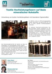
neue Endversion16112006.indd - ULV Leoben - Montanuniversität ...
neue Endversion16112006.indd - ULV Leoben - Montanuniversität ...
neue Endversion16112006.indd - ULV Leoben - Montanuniversität ...

Sie wollen auch ein ePaper? Erhöhen Sie die Reichweite Ihrer Titel.
YUMPU macht aus Druck-PDFs automatisch weboptimierte ePaper, die Google liebt.
mMINING METALLURGY MATERIALS<br />
m m<br />
WWW.UNILEOBEN.AC.AT<br />
Spatial Mapping on the Globe<br />
Fast representing GIS analysis results using no cost internet tools<br />
Fig.1. Watershed of the Prespa basin with Lake Ohrid in the<br />
background<br />
The extraordinal power of the tool in visualizing spatial data on the<br />
globe is not only in being able to deliver custom dynamic view-specific<br />
and time-specific content to individual GE client explorers, but<br />
also in the fact that researchers can individually combine these layers<br />
and communicate them via internet to support fast decision making.<br />
Layers such as watersheds (Fig.1) geology (Fig.2), hydrogeology,<br />
Corine Land Cover etc. were produced externally in ArcGIS<br />
before converting with special extension to the KML (Keyhole<br />
Mark up Language) GE format. Uploading these KMLs on online<br />
web-servers, these “Network Links” allow individuals, researchers,<br />
and other organizations to easily publish/preview dynamic geospatial<br />
data layers and have them seamlessly integrated into the unified GE<br />
environment .<br />
More to see on the http://www.traborema.net homepage<br />
Lajos Dobrosi<br />
Lehrstuhl für Technische<br />
Ökosystemanalyse<br />
an der MUL seit: 8/2001<br />
Zur Person:<br />
Seit 2004 Doktorand bei Prof. Wolfbauer<br />
Studium Industrieller Umweltschutz<br />
EDV-beuftragter, Universitätsassistent<br />
Electrotechnic, IT<br />
Universitätslehrerverband der<br />
<strong>Montanuniversität</strong> <strong>Leoben</strong> (<strong>ULV</strong>)<br />
The TRABOREMA EU-Project is focused partly on investigation<br />
of quantitative spatial data of environment to define policies<br />
for sustainable regional trans-boundary development. For integrated<br />
trans-boundary water management in the cross border<br />
region of Albania, Former Yugoslav Republic of Macedonia<br />
(FYROM) and Greece (Western Balkans), the freely available<br />
visualizing tool Google Earth® (GE) is used - as an important<br />
supplement to expensive GIS systems for networking purposes.<br />
It provides multimedia 2D/3D modeling features and monitoring<br />
measurements of the Prespas eco-system. Therefore the<br />
wide used GE Pro was selected for fast representing analysis<br />
results for the research community and stakeholders of the<br />
region.<br />
Fig.2. Geology of Prespa basin - Micro Prespa - Greek<br />
territory<br />
Forschungsschwerpunkte:<br />
Spatial Decision Support Systems (SDSS)<br />
Nonlinear change and systems (System Dynamics via Vensim)<br />
Geoinformatics (GIS)<br />
Modeling bio-energy systems<br />
Digital data processing & Bildverarbeitung<br />
Programming (Python, VB)<br />
Software development