Gesamte Ausgabe als PDF-Datei betrachten/Download
Gesamte Ausgabe als PDF-Datei betrachten/Download
Gesamte Ausgabe als PDF-Datei betrachten/Download

Sie wollen auch ein ePaper? Erhöhen Sie die Reichweite Ihrer Titel.
YUMPU macht aus Druck-PDFs automatisch weboptimierte ePaper, die Google liebt.
Summary<br />
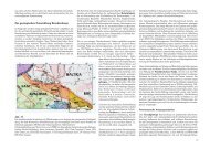
Near to the place Zechow the Rheinsberg Rhin crosses a<br />
distinctive end moraine belt of the so called Frankfurt ice<br />
advance. Concerning to the results of pebble analysis this<br />
end moraine contains near-surface till of saalian age. This<br />
fact can be regarded as an indication for older formative<br />
influences. According to lithostratigraphical research and<br />
radiocarbon dating hillside layers of this till are cohesive<br />
with the glacier advance from the Pomeranian stadium until<br />
the Rheinsberg basin.<br />
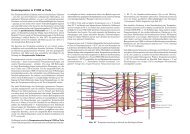
From the Rheinsberg basin up to the estuary in the Ruppin<br />
Rinne near Zippelsförde the Rhin is characterized by four<br />
paleolevels.<br />
The periglacial cover sands of the 2 nd - 4 th paleolevels have<br />
comparable lithostratigraphical sequences, what indicates<br />
very similar dates of origin. The basin edges give evidence<br />
to differences concerning the intensity of the periglacial<br />
processes during the late glacial. Different generations of<br />
periglacial dry valley can be found there. The formation<br />
of the 2 nd - 4 th paleolevels goes mainly back to the gradual<br />
thawing of dead ice in the Ruppin Rinne. In this process the<br />
Ruppin Rinne was the area of accumulation for the sediments,<br />
which cleared out during the incision of the paleolevels<br />
of the Rhin. The fluvial development of the Rhin<br />
course has been restricted to the first paleolevel and the<br />
Rhin meadows since the Oldest Dryas. The sequence of<br />
this development is reflected as well in the sequences of<br />
the Rhin alluvial cone in the Ruppin Rinne. These two corresponding<br />
developments are defined and characterized by<br />
both radiocarbon dating and pollen analysis. After the Prealleroed<br />
incision down to below the recent Rhin level and<br />
an Alleroed fluviatile rest period, the late glacial paleolevel<br />
began to elevate of about 1 m beginning with the Younger<br />
Dryas. Since the Atlanticum an anthropogenic induced incision<br />
of the Rhin up to recent level has begun. The Holocene<br />
fluviatile processes are documented with high resolution in<br />
the alluvial cone.<br />
The aeolian sequences of the Rhin Channel can well be<br />
classified in the region of the eastern valley slopes. The<br />
profiles show sequences of Prealleroed drift sands, a typical<br />
phenomenon for the Brandenburg lowlands, covered by<br />
Finow Alleroed soil. They are followed by aeolian Younger<br />
Dryas sediments. According to the radiocarbon dating<br />
of the paleolevels the hillside layers consist of Older and<br />
Younger Holocene drift sands.<br />
Literatur<br />
BraMer, H. (1991): Stratigraphische Skala des Quartärs.<br />
- In: Physische Geographie Mecklenburg-Vorpommern,<br />
Brandenburg, Sachsen-Anhalt, Sachsen, Thüringen. -<br />
213 S., Gotha<br />
BusseMer, s., Gärtner, P. & n. schlaak (1998): Stratigraphie,<br />
Stoffbestand und Reliefwirksamkeit der Flugsande<br />
im brandenburgischen Jungmoränenland. - Petermanns<br />
Geographische Mitteilungen 142, S. 115-125, Gotha<br />
Peter Gärtner<br />
GaGel, C. (1920): Erläuterungen zur Geologischen Karte<br />
von Preußen – Blatt Dierberg. - Preußische Geologische<br />
Landesanstalt, Berlin<br />
Gärtner, P. (1993): Zur Tal- und Flußentwicklung der Panke<br />
im Jungpleistozän. - Berliner Geographische Arbeiten<br />
78, S. 117-136, Berlin<br />
Gärtner, P. (1998): Neue Erkenntnisse zur jungquartären<br />
Landschaftsentwicklung in Nordwestbrandenburg – Eine<br />
landschaftsgenetische Studie am Ausgang des Rheinsberger<br />
Beckens. - Münchener Geographische Arbeiten A<br />
49, S. 95-116, München<br />
Gärtner, P. (2002): Nordbrandenburgische Flußentwicklung<br />
am Beispiel des Rheinsberger Rhin. - Greifswalder<br />
Geographische Arbeiten 26, S. 27-30, Greifswald<br />
Jahnke, W. & H. Reinhard (1968): Zur spätglazialen Gletscherdynamik<br />
und Entwicklungsgeschichte der großen<br />
Talungen im Nordosten Mecklenburgs. - Wiss. Z. Univ.<br />
Greifswald, Math. - Nat. R., S. 1-20, Greifswald<br />
Keilhack, K. (1921): Geologische Übersichtskarte von<br />
Deutschland im Maßstab 1 : 500 000. - Preußische Geologische<br />
Landesanstalt, Berlin<br />
Kozarski, S. (1991): Warta – A Case Study of a Lowland<br />
River. - In: Starkel, L., GreGory, K. J. & J. B. Thornes:<br />
Temperate Paleohydrology. - S. 189-215, Chister, New<br />
York (John Wiley and Sons)<br />
Marcinek, J. (1981): Kleiner Führer zum Rheinsberger<br />
Becken. - Berlin<br />
Marcinek, J. & ZauMseil, L. (1993): Brandenburg und Berlin<br />
im physisch- geographischen Überblick. - Geograph.<br />
Rundsch. 45, S. 556-563, Braunschweig<br />
PaPenroth, R. (1998): Holozäne Landschaftsentwicklung<br />
im Bereich der Rhinmündung bei Zippelsförde. - Diplomarbeit,<br />
Geographisches Institut, 70 S., Berlin<br />
Schlaak, N. (1993): Studie zur Landschaftsgenese im<br />
Raum Nordbarnim und Eberswalder Urstromtal. - Berl.<br />
Geogr. Arb. 76, S. 1-160, Berlin<br />
Anschrift des Autors:<br />
Dr. Peter Gärtner<br />
Lanker Weg 38<br />
16348 Wandlitz<br />
e-mail: apm.Gaertner@freenet.de<br />
36 Brandenburgische Geowissenschaftliche Beiträge 1-2007