Brenner Basistunnel: Realisierungsstand Brenner Base Tunnel ...
Brenner Basistunnel: Realisierungsstand Brenner Base Tunnel ...
Brenner Basistunnel: Realisierungsstand Brenner Base Tunnel ...

Sie wollen auch ein ePaper? Erhöhen Sie die Reichweite Ihrer Titel.
YUMPU macht aus Druck-PDFs automatisch weboptimierte ePaper, die Google liebt.
18 Österreich<br />
Austria<br />
<strong>Tunnel</strong> 2/2011<br />
<strong>Brenner</strong> <strong>Basistunnel</strong>:<br />
<strong>Realisierungsstand</strong><br />
Der 64 km lange <strong>Brenner</strong> <strong>Basistunnel</strong> (BBT) ist<br />
ein flach verlaufender Eisenbahntunnel zwischen<br />
Innsbruck/A und Franzensfeste/I. Er ist Teil<br />
der europäischen TEN 1 Achse, die den Ausbau<br />
eines länderübergreifenden Schienenkorridors<br />
vorsieht (Bild 1). Der BBT besteht aus 2 parallelen<br />
Hauptröhren sowie einem darunter liegenden<br />
Erkundungsstollen. Im März 2011 sind<br />
16 km Erkundungsstollen und Zufahrtstunnel<br />
errichtet. Im folgenden Beitrag wird der aktuelle<br />
Stand der Arbeiten dargestellt.<br />
<strong>Brenner</strong> <strong>Base</strong> <strong>Tunnel</strong>:<br />
Project status<br />
The 64 km long <strong>Brenner</strong> <strong>Base</strong> <strong>Tunnel</strong> (BBT) is<br />
a flat trajectory railway tunnel between Innsbruck/A<br />
and Franzenfeste/I. It is part of the European<br />
TEN 1 axis, which foresees the construction<br />
on a rail corridor linking countries together.<br />
The BBT comprises 2 parallel main bores as well<br />
as the exploratory bore located beneath them.<br />
In March 2011, 16 km of exploratory tunnel and<br />
access tunnel had been completed. The following<br />
report deals with the stage reached by<br />
the construction activities.<br />
1 Technisches Konzept<br />
Der <strong>Brenner</strong> <strong>Basistunnel</strong> ist<br />
ein nahezu horizontal verlaufender<br />
Eisenbahntunnel mit<br />
zwei parallelen Röhren. Der<br />
<strong>Tunnel</strong> weist zwischen den<br />
Bahnhöfen Innsbruck und<br />
Franzensfeste eine Länge von<br />
55 km auf und wird südlich von<br />
Innsbruck mit der bereits bestehenden<br />
auch unterirdisch<br />
verlaufenden Umfahrung verbunden.<br />
Mit dieser Umfahrung<br />
und dem <strong>Basistunnel</strong> entsteht<br />
damit die weltweit längste unterirdische<br />
Eisenbahnstrecke<br />
mit einer Gesamtlänge von<br />
etwa 64 km.<br />
Mittig unterhalb der beiden<br />
Eisenbahntunnelröhren<br />
befindet sich 12 m tiefer ein<br />
Erkundungsstollen. Dieser wird<br />
zuerst abschnittsweise vor dem<br />
Bau der Hauptröhren errichtet,<br />
um hauptsächlich das Gebirge<br />
zu erkunden. Im endgültigen<br />
Ausbau wird dieser Erkundungsstollen<br />
durchgehend<br />
gebaut, sodass er dann als<br />
Entwässerungsstollen und bei<br />
Notwendigkeit als Dienststollen<br />
genützt werden kann [1].<br />
Univ. Prof. Dipl.-Ing. Dr. Dr. Konrad Bergmeister, <strong>Brenner</strong> <strong>Basistunnel</strong> BBT SE,<br />
Innsbruck/A, konrad.bergmeister@bbt-se.com, www.bbt-se.com<br />
Die wichtigsten Kenndaten<br />
des <strong>Brenner</strong> <strong>Basistunnel</strong>s mit<br />
der Umfahrung von Innsbruck<br />
sind (Bild 2):<br />
• Länge:<br />
64 km<br />
• Längsneigung:<br />
5,0 ‰ bis 6,7 ‰<br />
• Scheitelhöhe des <strong>Basistunnel</strong>s:<br />
795 m ü.d.M.<br />
• Nettoquerschnitt der<br />
Hauptröhren:<br />
ca. 43 m 2<br />
• Minimalquerschnitt des<br />
Erkundungsstollens:<br />
ca. 26 m 2<br />
• Abstand der Querschläge:<br />
300 m.<br />
2 Aktueller <strong>Realisierungsstand</strong><br />
2.1 Stand der Genehmigungen<br />
Das technische Projekt und die<br />
Umweltverträglichkeit wurde<br />
bereits 2009 von den Staaten<br />
Österreich (15. April 2009 Eisenbahnrechtliche<br />
und UVP-<br />
Genehmigung) und Italien<br />
1 Basic concept<br />
The <strong>Brenner</strong> <strong>Base</strong> <strong>Tunnel</strong> is a nearly<br />
horizontal rail tunnel with 2<br />
parallel tubes. The tunnel runs<br />
for 55 km between the railway<br />
stations of Innsbruck and Fortezza<br />
and is connected south<br />
of Innsbruck with the already<br />
existing underground by-pass.<br />
This bypass and the <strong>Base</strong> <strong>Tunnel</strong><br />
make up the world‘s longest underground<br />
railway, with a total<br />
length of about 64 km.<br />
An exploratory tunnel runs<br />
between and 12 m deeper than<br />
the 2 tubes of the rail tunnel.<br />
This will be built in sections<br />
before the construction of the<br />
main tubes, primarily to explore<br />
the rock mass. This exploratory<br />
tunnel will be completed to run<br />
end-to-end in the final phase<br />
of construction, so that it may<br />
be utilized as a drainage tunnel<br />
and, if necessary, as a service<br />
tunnel [1].<br />
The main characteristics of the<br />
<strong>Brenner</strong> <strong>Base</strong> <strong>Tunnel</strong> are (Figure 2):<br />
• Length:<br />
64 km<br />
• Longitudinal gradient:<br />
5.0 ‰ to 6.7 ‰<br />
• Crown height of the <strong>Base</strong><br />
<strong>Tunnel</strong>:<br />
795 m above sea level<br />
• Net cross-section of the<br />
main tubes:<br />
about 43 m 2<br />
• Minimum cross-section of<br />
the exploratory tunnel:<br />
about 26 m 2<br />
• Clearance of the cross-cuts:<br />
300 m.<br />
2 Current planning<br />
status<br />
2.1 Current state of the authorization<br />
procedures<br />
The technical project was authorized<br />
and the environmental<br />
compatibility confirmed by the<br />
governments of Austria (April<br />
15 th 2009 authorization according<br />
to the Austrian law on railways<br />
and EIA approval) and Italy<br />
(July 31 th 2009 CIPE decision) in<br />
2009. By the end of 2010 preparatory<br />
work was undertaken and<br />
approx. 15 km of the exploratory<br />
tunnel and the access tunnel had
<strong>Tunnel</strong> 2/2011<br />
<strong>Brenner</strong> <strong>Basistunnel</strong> <strong>Brenner</strong> <strong>Base</strong> <strong>Tunnel</strong><br />
19<br />
(31. Juli 2009 CIPE-Beschluss)<br />
genehmigt. Bis Ende 2010<br />
wurden bauvorbereitende Arbeiten<br />
und etwa 15 km an Erkundungs-<br />
und Zugangsstollen<br />
gebaut. In der Phase I, zwischen<br />
1999 und 2002 wurde das Vorprojekt<br />
erarbeitet. Ab 2003 bis<br />
2008 wurden im Rahmen der<br />
Phase II über 26.000 m an Erkundungsbohrungen,<br />
das technische<br />
Einreichprojekt und die<br />
Planungen zur Umweltverträglichkeit<br />
durchgeführt.<br />
Am 18. November 2010<br />
wurde in Italien durch eine<br />
weitere CIPE-Genehmigung<br />
die weitere Finanzierung und<br />
der Beginn der Phase III (Realisierungsphase)<br />
beschlossen. In<br />
Österreich hat der Ministerrat<br />
am 1. Februar 2011 die weitere<br />
Finanzierung von Bauarbeiten<br />
zur Bauvorbereitung und vertieften<br />
Erkundung beschlossen.<br />
Mit der Errichtung der Hauptbaulose<br />
soll 2016 begonnen<br />
werden. Die Fertigstellung<br />
des <strong>Brenner</strong> <strong>Basistunnel</strong>s ist<br />
für 2025 geplant.<br />
2.2 Projektübergreifende<br />
Regelplanung (guide design)<br />
Im Februar 2011 wurde die<br />
projektübergreifende Regelplanung<br />
europaweit ausgeschrieben.<br />
Durch diese gesamtheitliche<br />
Planungsgrundlage soll<br />
eine homogene und solide<br />
Basis für die Folgeplanungen<br />
gebildet werden. Die wesentlichen<br />
Elemente dieser gesamtheitlichen<br />
Planung sind:<br />
• Überarbeitung der Trassierung<br />
mit Einarbeitung sämtlicher<br />
Optimierungen<br />
• Normative Grundlagen und<br />
technische Vorgaben für<br />
die losbezogene Ausschreibungs-<br />
und Ausführungsplanung<br />
• Grundsätze für die Bemessung,<br />
die konstruktive Durchbildung<br />
für eine Lebensdauer<br />
von 200 Jahren<br />
• Erstellen von detaillierten<br />
Schnittstellen- und Typenplänen<br />
• Toleranzvorgaben (vermessungs-<br />
und baumethodenabhängige<br />
Toleranzen) unter<br />
Berücksichtigung der Folgegewerke<br />
• Vorkehrungen für den bahntechnischen<br />
Ausbau.<br />
Alpenquerende Eisenbahntransversale<br />
Transalpine Railwayline<br />
Zusätzlich wird die gesamte<br />
Trassierung vom UTM in ein<br />
projektbezogenes Koordinatensystem<br />
BBT-TM gebracht,<br />
das durch eine transversale<br />
Mercatorprojektion erzeugt<br />
wird. Damit wird die mittlere<br />
Projekthöhe von 720 m orbeen<br />
built. In phase I, from 1999<br />
to 2002, the preliminary project<br />
was developed. Between 2003<br />
and 2008, in phase II, more than<br />
26.000 m of prospection borings,<br />
the technical final project and the<br />
1<br />
Technical excellence. Flexibility. Experience. Reliability. These are some of the factors for our success in this business.<br />
What really sets us apart however, is the way we think. Our mission is to continuously move forward and find<br />
innovative approaches in order to meet your requirements. For new perspectives in underground engineering.<br />
<br />
<br />
<br />
<br />
<br />
Technische Exzellenz. Flexibilität. Erfahrung. Verlässlichkeit.<br />
Damit bestehen wir im Wettbewerb.<br />
<br />
Was uns <br />
wirklich auszeichnet, ist aber unser Denken.<br />
Unser Anspruch, weiterzugehen und nach innovativen<br />
Ansätzen zu suchen, um Ihre Anforderungen zu erfüllen.<br />
Für neue Perspektiven im Untertagebau.<br />
JAG_<strong>Tunnel</strong>_186x63.indd 1 24.02.11 14:46
20 Österreich<br />
Austria <strong>Tunnel</strong> 2/2011<br />
• Regulatory principles and<br />
technical specifications for<br />
the lot-based tendering and<br />
executive planning<br />
• Principles for the design and<br />
construction detailing for a<br />
service lifetime of 200 years<br />
• Creation of detailed interface<br />
and type plans<br />
• Tolerances (surveying and<br />
construction method-dependent<br />
tolerances), taking<br />
into account the subsequent<br />
works<br />
• Measures for development of<br />
the railway infrastructure.<br />
2<br />
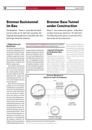
Regelquerschnitt durch TBM<br />
Standard cross-section of the TBM<br />
thometrische Höhe festgelegt,<br />
was ca. 770 m ellipsoidischer<br />
Höhe entspricht. Das Projekt<br />
liegt somit in einem Gebiet ca.<br />
10 km östlich und westlich vom<br />
Mittelmeridian. In diesem Fall<br />
beträgt die Streckenverzerrung<br />
weniger als 2 bis 3 mm/km.<br />
Im so geschaffenen Bezugssystem<br />
muss keine weitere Rotation<br />
durchgeführt werden, da<br />
die Meridiankonvergenz einfach<br />
zu berechnen ist und der<br />
sich daraus ergebende Reduktionseffekt<br />
auf die Richtungen<br />
unbedeutend ist (der Konvergenzwinkel<br />
beträgt ca. 4’).<br />
2.3 Georeferenzierte<br />
Planungsgrundlagen<br />
Die gesamte Planung des <strong>Brenner</strong><br />
<strong>Basistunnel</strong>s wurde auf georeferenzierten<br />
Daten aufgebaut<br />
[2]. Das Projekt wurde mit<br />
den Koordinaten UTM-WGS84<br />
ausgearbeitet. Man bediente<br />
sich dabei der internationalen<br />
Vereinbarung, bei der die<br />
Projektion der ellipsoidischen<br />
geographischen Koordinaten<br />
WGS84 nach Gauss erfolgt.<br />
Mittels querachsiger Zylinderprojektion<br />
wurde mit einem<br />
Massstabsfaktor von 0.9996<br />
und unter Verwendung des<br />
Streifens 32 gerechnet; bei diesem<br />
Ansatz ist der Mittelmeridian<br />
bei 9° Länge und besitzt eine<br />
E-Koordinate von 500 km, während<br />
die N-Koordinaten ihren<br />
Ursprung am Äquator haben.<br />
Das Projektgebiet liegt am<br />
östlichen Punkt 2°40’ vom<br />
Mittelmeridian des Streifens<br />
entfernt; daher ist auch die<br />
Meridiankonvergenz, sprich<br />
der Unterschied zwischen dem<br />
geographischen und dem Gitternord,<br />
beträchtlich. Daher ist<br />
es vorteilhaft, die Projektdaten<br />
in ein ebenes Bezugssystem zu<br />
transformieren, das den Trasplanning<br />
for environmental compatibility<br />
were completed.<br />
On November 18 th , 2010 further<br />
financing and the start of phase<br />
III (building phase) in Italy were<br />
approved by CIPE. On February<br />
1 st ,2011 Austria´s federal Cabinet<br />
approved further financing of preparatory<br />
construction works and<br />
in-depth prospection. The start<br />
of construction work in the main<br />
construction lots is scheduled for<br />
2016 and the completion of the<br />
<strong>Brenner</strong> <strong>Base</strong> <strong>Tunnel</strong> for 2025.<br />
2.2 Cross-project system planning<br />
(guide design)<br />
In February 2011, the cross-project<br />
system planning was tendered<br />
Europe-wide, to create a solid,<br />
uniform basis for subsequent<br />
planning. The essential elements<br />
of this integrated planning are:<br />
• Revision of the route planning<br />
incorporating all optimizations<br />
In addition, the entire UTM-based<br />
route planning was placed in a<br />
project-specific coordinate system:<br />
BBT-TM, produced by a transverse<br />
Mercator projection. Thus, the average<br />
orthometric height of 720 m<br />
for the project was determined,<br />
which is about a 770 m ellipsoidal<br />
height. The project lies therefore<br />
in an area about 10 km east and<br />
west of the central meridian. The<br />
distance distortion in this case is<br />
less than 2 to 3 mm/km.<br />
Thus, for this reference system,<br />
no further rotation must<br />
be performed, as the meridian<br />
convergence is easy to calculate<br />
and the resulting reduction<br />
effect on the directions is insignificant<br />
(the convergence angle<br />
is about 4‘).<br />
2.3 Geo-referenced data<br />
and WebGis<br />
The entire planning of the <strong>Brenner</strong><br />
<strong>Base</strong> <strong>Tunnel</strong> was based on georeferenced<br />
data. The project was<br />
developed with UTM -WGS84 coordinates,<br />
using the international<br />
agreement for the projection of<br />
the WGS84 ellipsoidal geographic<br />
coordinates according to Gauss.<br />
Calculation was done by means of<br />
a transverse cylindrical projection,<br />
applying a scale factor of 0.9996<br />
for strip 32; using this approach
<strong>Tunnel</strong> 2/2011<br />
<strong>Brenner</strong> <strong>Basistunnel</strong> <strong>Brenner</strong> <strong>Base</strong> <strong>Tunnel</strong><br />
21<br />
sierungstätigkeiten besser angepasst<br />
ist. Damit werden die<br />
Unterschiede zwischen den<br />
Projektdaten und den Trassierungsdaten<br />
minimal und auch<br />
am Rand unbedeutend:<br />
System UTM-WGS84<br />
Ost = 692294,890<br />
Nord = 5206131,024<br />
H (UELN)= 804,942<br />
Long. = 11° 31’ 42.5775”<br />
• Lat. = 46° 58’ 50.7947”<br />
Der Berührungspunkt des Zylinders<br />
ans Ellipsoid ist der Schwerpunkt<br />
des Projektes, das ist der<br />
Hochpunkt der Projektachse<br />
(Ost-Röhre – Gl.1) und liegt in<br />
der Nähe der Staatsgrenze zwischen<br />
Italien und Österreich.<br />
Für die geographische Definition<br />
derselben werden folgende<br />
Kenndaten verwendet:<br />
Ellipsoid WGS84<br />
• Mittelmeridian des Streifens =<br />
11° 31’ 42.5775”<br />
• Gebrauchskoordinate<br />
Ost = y0 = 20000.000 m<br />
• Gebrauchskoordinate<br />
Nord = x0 = -5105739,717 m<br />
• Maßstab Faktor = 1.000121<br />
Der Vorteil bei dieser Vorgehensweise<br />
liegt darin, dass für<br />
das gesamte Bauwerk ein einziges<br />
System verwendet werden<br />
kann, und dies ohne die<br />
Probleme, die normalerweise<br />
entstehen, wenn für jeden <strong>Tunnel</strong>abschnitt<br />
andere Systeme<br />
verwendet werden.<br />
Das neue Bezugssystem,<br />
das von einer transversalen<br />
Mercatorprojektion erzeugt<br />
wird, trägt die Bezeichnung<br />
BBT_TM-WGS84 und wird folgende<br />
Koordinaten haben:<br />
x (Nord); y (Ost).<br />
3 Bauzeitplan<br />
Das Bauprogramm des <strong>Brenner</strong><br />
<strong>Basistunnel</strong>s 2010 wurde<br />
Kostengruppe<br />
Rohbau 65 %<br />
Ausrüstung 15 %<br />
Management und Grundeinlöse 12,5 %<br />
Risikovorsorge 7,5 %<br />
Gesamt (Preisbasis 1. Januar 2010) 7,46 Mrd. €<br />
Tabelle 1: Kosten des <strong>Brenner</strong> <strong>Basistunnel</strong>s nach Kostengruppen<br />
Cost group<br />
Basic structure 65 %<br />
Outfitting and Equipment 15 %<br />
Management and land acquisition 12,5 %<br />
Provision for risks 7,5 %<br />
Total (<strong>Base</strong> Price 1 January 2010) 7.46 billion €<br />
Table 1: Costs of <strong>Brenner</strong> <strong>Base</strong> <strong>Tunnel</strong> by cost groups<br />
auf Basis der UVP-Genehmigungen<br />
von vielen Optimierungen<br />
erstellt. Nach einer eingehenden<br />
Analyse wurde das<br />
Bauprogramm in Form eines<br />
Weg-Zeit-Diagramms erstellt.<br />
Notwendig war es dabei neben<br />
den verschiedenen Vortriebsmethoden<br />
auch die Planungs- und<br />
Ausschreibungs- bzw. Vergabezeiten<br />
zu berücksichtigen. Zusätzlich<br />
wurden internationale<br />
Erfahrungen bereits realisierter<br />
<strong>Tunnel</strong>bauten einbezogen. Das<br />
Weg-Zeit-Diagramm umfasst die<br />
gesamten Bautätigkeiten vom<br />
Rohbau bis zur Inbetriebnahme<br />
und die dazu notwendigen Planungsleistungen<br />
ohne Berücksichtigung<br />
der derzeit noch nicht<br />
bekannten Projektrisiken.<br />
Das weitere Bauprogramm<br />
sieht eine Aufteilung der Arbeiten<br />
in 5 Hauptbaulose vor:<br />
• 2 Baulose für den Erkundungsstollen<br />
und zur Bauvorbereitung<br />
sowie<br />
• 3 Hauptbaulose.<br />
Der durchgehende Erkundungsstollen<br />
wird etwa 1/3<br />
konventionell und 2/3 maschinell<br />
vorgetrieben. Die Zufahrtstunnel<br />
werden ausschließ-<br />
the central meridian is at 9° longitude,<br />
with an E-coordinate of<br />
500 km, while the N-coordinates<br />
originate at the equator.<br />
Sicher. Dauerhaft.<br />
The project area is located 2°40‘<br />
east of the central meridian of<br />
the strip; so, the meridian convergence,<br />
or the difference<br />
between geographical and<br />
grid north, is considerable.<br />
Therefore, it is advantageous<br />
to transform the project data<br />
into a flat reference system<br />
that is better adapted to route<br />
planning operations. The differences<br />
between the project<br />
data and the line routing are<br />
therefore minimal and marginally<br />
insignificant:<br />
UTM-WGS84 system<br />
East = 692294.890<br />
North = 5206131.024<br />
H (UELN) = 804.942<br />
Long. = 11° 31’ 42.5775”<br />
• Lat. = 46° 58’ 50.7947”<br />
<strong>Tunnel</strong>tore von Elkuch Bator.<br />
Für höchste Anforderungen.<br />
Strengstens erprobt.<br />
Zum Beispiel am Lötschberg<br />
und Gotthard <strong>Basistunnel</strong>.<br />
Zur Sicherheit!<br />
Elkuch Bator | Herzogenbuchsee | www.elkuch.com | T +41 62 956 20 50
22 Österreich<br />
Austria <strong>Tunnel</strong> 2/2011<br />
Bauprogramm <strong>Brenner</strong>-<strong>Basistunnel</strong> 2010 / Construction Schedule 2010 of <strong>Brenner</strong> <strong>Base</strong> <strong>Tunnel</strong><br />
3<br />
Bauzeitplan 2010 des <strong>Brenner</strong> <strong>Basistunnel</strong>s – auch als „Bergmeister-Plan“ bekannt geworden<br />
Construction Schedule 2010 of <strong>Brenner</strong> <strong>Base</strong> <strong>Tunnel</strong> – also known as „Bergmeister Plan“
<strong>Tunnel</strong> 2/2011<br />
<strong>Brenner</strong> <strong>Basistunnel</strong> <strong>Brenner</strong> <strong>Base</strong> <strong>Tunnel</strong><br />
23<br />
Liebe Leser,<br />
leider ist der Bauzeitplan im<br />
Büro des <strong>Brenner</strong> <strong>Basistunnel</strong>s<br />
ganze 1,40 m breit und damit<br />
einfach viel zu groß, um hier<br />
lesbar ohne Lupe abgedruckt<br />
werden zu können. Aber Sie<br />
haben die Möglichkeit, auf<br />
Ihrer tunnel-homepage unter<br />
www.tunnel-online.info im<br />
Suchfeld folgenden webcode<br />
„TNL0O5CZ“ einzugeben und<br />
direkt im pdf zu landen, das Sie<br />
sich dann entsprechend vergrößert<br />
anschauen können.<br />
Dear reader,<br />
unfortunately this construction<br />
schedule is only available in a<br />
width of 1.40 m in the <strong>Brenner</strong><br />
<strong>Base</strong> <strong>Tunnel</strong> office. And this is<br />
not possible to print without giving<br />
you a magnifiying glass to<br />
read. But you´re lucky to choose<br />
your tunnel-homepage www.<br />
tunnel-online.info and insert the<br />
following webcode “TNL0O5CZ”<br />
in the search button. If you do<br />
this, you directly will open a pdf<br />
where you can have a look on the<br />
schedule much more bigger.
24 Österreich<br />
Austria <strong>Tunnel</strong> 2/2011<br />
4<br />
Geologisches Längsprofil<br />
Geological longitudinal section<br />
lich konventionell hergestellt.<br />
Beim Bau der Hauptbaulose<br />
teilen sich die Bauverfahren<br />
auf etwa 1/4 konventionelle<br />
und 3/4 maschinelle Bauverfahren<br />
auf. Auch die Verbindungstunnel<br />
mit der Umfahrung<br />
von Innsbruck werden<br />
konventionell hergestellt.<br />
Das Bauprogramm 2010 des<br />
<strong>Brenner</strong> <strong>Basistunnel</strong>s wurde auf<br />
Basis der UVP-Genehmigungen,<br />
neuer baulogistischer Optimierungen<br />
und verbesserter geologischer<br />
und hydrogeologischer<br />
Kenntnisse erarbeitet.<br />
Dieser Bauzeitplan (wird in den<br />
Medien als Bergmeister-Plan<br />
bezeichnet) wurde im Aufsichtsrat<br />
der BBT SE genehmigt<br />
und bildet die Grundlage für<br />
die weiteren Investitionsmittelabflüsse<br />
und Bauvorhaben<br />
(Bild 3).<br />
4 Prognostizierte<br />
Gesamtkosten<br />
Die Kosten des <strong>Brenner</strong> <strong>Basistunnel</strong>s<br />
wurden auf der Grundlage<br />
des Einreichprojektes 2008<br />
großteils mit der Positionsmethode<br />
ermittelt. Zusätzlich<br />
wurden die Kosten der vorgeschriebenen<br />
UVP-Maßnahmen<br />
und der externen Bewertung<br />
berücksichtigt. Auch wurde<br />
eine Valorisierung der prognostizierten<br />
Gesamtkosten<br />
vom 1. Juli 2006 bis zum 1.<br />
Januar 2010 durchgeführt<br />
(Tabelle 1).<br />
Im Risikoanteil wurden<br />
auf der Grundlage einer analytischen<br />
Risikoanalyse die<br />
identifizierten Risiken mit einer<br />
hohen und mittleren Eintrittswahrscheinlichkeit<br />
berücksichtigt.<br />
Zur Berücksichtigung<br />
der erwartbaren, aber derzeit<br />
noch nicht identifizierbaren<br />
und quantifizierbaren Risiken<br />
wurde auf der Grundlage der<br />
österreichischen ÖGG-Richtlinie:<br />
„Kostenermittlung für<br />
Projekte der Verkehrsinfrastruktur“<br />
(Version 2005) eine<br />
Abschätzung der notwendigen<br />
Risikovorsorge aufgrund von<br />
langjährigen Erfahrungswerten<br />
für Infrastrukturprojekte vorgenommen<br />
[3]. Dieser zusätzliche<br />
Anteil errechnet sich auf 602<br />
Mio. Euro. Aufgrund der österreichischen<br />
ÖGG-Richtlinie<br />
errechnet sich eine gesamte<br />
Risikovorsorge auf 1.144 Mio.<br />
Euro (theoretisch ermittelte Risikovorsorge<br />
mit mittlerer und<br />
hoher Eintrittswahrscheinlichkeit<br />
und die erwartbaren, aber<br />
The point of contact of the cylinder<br />
to the ellipsoid is the focus<br />
of the project, which is the high<br />
point of the project axis (Easttube<br />
- Tr.1) and lies near the border<br />
between Italy and Austria.<br />
The following data are used for<br />
the geographical definition:<br />
Ellipsoid WGS84<br />
• Central meridian of the strip =<br />
11° 31‘ 42.5775“<br />
• Function coordinate<br />
East = y0 = 20000,000 m<br />
• Function coordinate<br />
North = x0 = -5105739.717 m<br />
• Scale factor = 1.000121<br />
The advantage of this approach<br />
is that a single system can be<br />
used for the entire construction<br />
project, without the problems<br />
arising that are ordinarily incurred<br />
when different systems are used<br />
for each tunnel sections.<br />
The new reference system,<br />
which is produced by a transverse<br />
Mercator projection, is<br />
called BBT_TM-WGS84 and will<br />
have the following coordinates:<br />
x (North), y (East).<br />
3 Construction schedule<br />
The 2010 <strong>Brenner</strong> <strong>Base</strong> <strong>Tunnel</strong><br />
construction program was<br />
prepared on the basis of many<br />
improvements according to EIA<br />
approvals. The construction program<br />
was set forth in the form of<br />
a time-phased workload chart<br />
following a detailed analysis. It<br />
was necessary to take into account,<br />
besides the various tunnelling<br />
methods, the planning<br />
and tendering and procurement<br />
times. Additionally, international<br />
experience from already constructed<br />
tunnels was included.<br />
The time-phased workload diagram<br />
covers the entire range<br />
of construction activities from<br />
the structural work through to<br />
the start of operations and the<br />
necessary planning services<br />
without considering the yet<br />
unknown project risks.<br />
The program provides for the<br />
construction work to be divided<br />
into 5 main lots:<br />
• 2 construction lots for the<br />
exploratory tunnel and part<br />
of the main tunnel and<br />
• 3 main construction lots.<br />
About 1/3 of the exploratory<br />
tunnel is to be excavated with<br />
conventional and 2/3 with mechanical<br />
tunnelling methods. The<br />
access tunnels will be excava-
<strong>Tunnel</strong> 2/2011<br />
<strong>Brenner</strong> <strong>Basistunnel</strong> <strong>Brenner</strong> <strong>Base</strong> <strong>Tunnel</strong><br />
25<br />
derzeit weder quantifizierbaren<br />
noch identifizierbaren Risiken).<br />
Mit dieser Risikovorsorge errechnen<br />
sich die prognostizierten<br />
Gesamtkosten des <strong>Brenner</strong><br />
<strong>Basistunnel</strong>s bezogen auf den<br />
1. Januar 2010 auf 8.062 Mio.<br />
Euro.<br />
ted exclusively by conventional<br />
means. About 1/4 of the construction<br />
of the main building lots<br />
will take place with conventional<br />
and about 3/4 with mechanical<br />
excavation methods. The tunnels<br />
connecting with the Innsbruck<br />
by-pass are to be excavated conventionally.<br />
The 2010 <strong>Brenner</strong> <strong>Base</strong><br />
<strong>Tunnel</strong> building program was<br />
prepared according to EIA approvals,<br />
new improvements<br />
in construction logistics and<br />
improved geological and hydrological<br />
knowledge. This<br />
construction program (known<br />
to the media as the Bergmeister<br />
Plan) was approved by the BBT<br />
SE Supervisory Board and is the<br />
basis for further investments and<br />
works (Figure 3).<br />
4 Projected total costs<br />
The costs of the <strong>Brenner</strong> <strong>Base</strong><br />
<strong>Tunnel</strong> have been largely determined<br />
using the item method<br />
on the basis of the 2008 final<br />
project. In addition, the costs of<br />
compulsory EIA measures and<br />
external evaluation were considered.<br />
The estimated total costs<br />
from 1 July 2006 to 1 January<br />
2010 were also value-adjusted<br />
(Table 1).<br />
<strong>Base</strong>d on a risk analysis, the<br />
risks considered were those identified<br />
as having a medium and<br />
high probability of occurrence.<br />
In order to take account of those<br />
risks which may be expected but<br />
are currently not yet identifiable<br />
and quantifiable, the ÖBB (2007)<br />
manual to determine costs and<br />
the Austrian ÖGG directive „Cost<br />
www.coray.com<br />
FOR<br />
TUNNELING<br />
PROCESS OFFERING<br />
AND<br />
MINING<br />
> More than 60 countries being served<br />
Tell us your needs!<br />
www.normet.fi · www.taminternational.com<br />
NOR_110210_ImageAd_TUN_186x130.indd 1 10.02.11 13:15
26 Österreich<br />
Austria <strong>Tunnel</strong> 2/2011<br />
5 Geologische Erkenntnisse<br />
durch den Erkundungsstollen<br />
Der Bau der Erkundungsstollen<br />
dient primär der Vorerkundung<br />
[4]. Beim Erkundungsstollen<br />
Innsbruck – Ahrental wird die<br />
geologische Dokumentation<br />
von internem BBT-Personal<br />
durchgeführt, um das Wissen<br />
und die Erfahrung für die weitere<br />
Planung zu verbessern. In<br />
geologisch schwierigen Abschnitten<br />
(Störzonen) wird jeder<br />
Abschlag dokumentiert, bei<br />
monotonen Verhältnissen bzw.<br />
Abschnitten mit gleichbleibender<br />
Geologie jeder zweite<br />
Abschlag. Bei der geologischen<br />
Ortsbrustkartierung wird der<br />
anstehende Gesteinstyp, die<br />
gesteinsphysikalischen Parameter<br />
wie Härte und Verwitterung,<br />
die Ausbildung und<br />
Raumstellung der maßgeblichen<br />
Trennflächen und die<br />
Bergwasserverhältnisse beobachtet,<br />
gemessen und aufgezeichnet.<br />
Die dabei erhobenen<br />
Daten werden über die <strong>Tunnel</strong>datenbanksoftware<br />
„2-DOC“<br />
verwaltet und entsprechende<br />
Abschlagsberichte erstellt.<br />
Ebenso werden kontinuierlich<br />
geologische Längenschnitte<br />
erstellt, die die aufgefahrene<br />
Geologie zusammenfassend<br />
darstellen. Ebenso erfolgt in<br />
regelmäßigen Abständen eine<br />
Berichterstattung an die zuständige<br />
Behörde.<br />
Wertvolle Erkenntnisse<br />
konnten bereits bei beiden Erkundungsstollenabschnitten<br />
im Innsbrucker Quarzphyllit<br />
und im Brixner Granit gewonnen<br />
werden (Bild 4).<br />
5.1 Innsbrucker Quarzphyllit<br />
Die beiden <strong>Tunnel</strong>bauwerke<br />
Erkundungsstollen Innsbruck<br />
– Ahrental und der Zufahrtstunnel<br />
Ahrental des Erkundungsloses<br />
Innsbruck – Ahrental liegen<br />
zur Gänze in Gesteinen der<br />
Innsbrucker Quarzphyllitzone.<br />
Diese <strong>Tunnel</strong>abschnitte werden<br />
zyklisch mittels Sprengvortrieb<br />
erstellt [5]. Die Innsbrucker<br />
Quarzphyllitzone ist auf den<br />
ersten ca. 14 km des BBT-<strong>Tunnel</strong>systems<br />
vom Portal Innsbruck<br />
aus zu durchörtern. Sie<br />
reicht von Innsbruck, im Westen<br />
begrenzt durch das Wipptal,<br />
bis in das Navistal, wo sie mit<br />
Gesteinen des Tauernfensters<br />
verschuppt bzw. durch eine<br />
großangelegte Störungszone<br />
mit Gesteinen des Tauernfensters<br />
getrennt ist.<br />
Der „Quarzphyllit“ ist eine<br />
Wechsellagerung aus unterschiedlichen<br />
Phylliten mit<br />
quarzitischen und gneisigen<br />
Lagen. Es ist ein Gestein, das<br />
schiefrig bis dünnplattig bricht<br />
und hauptsächlich aus Schichtsilikaten<br />
(Glimmer) und Quarz<br />
besteht. Die Schieferung als<br />
Haupttrennfläche liegt flach.<br />
Der Quarzphyllit ist aufgrund<br />
seines hohen Glimmeranteils<br />
ein dichtes Gestein, es<br />
wurden vorab nur sehr geringe<br />
Wasserzuflüsse in den<br />
<strong>Tunnel</strong> prognostiziert. Die in<br />
ihm eingelagerten, kleinräumigen<br />
Kalkmarmor- und Dolomitmarmorkörper<br />
können<br />
mit Bergwasser angereichert<br />
sein. Werden sie beim <strong>Tunnel</strong>vortrieb<br />
„angestochen“ rinnt<br />
dieses Wasser binnen Tagen<br />
aus und versiegt dann. Dies<br />
wird trefflich mit dem Begriff<br />
des „Ausblutens“ bezeichnet.<br />
5.1.1 Erkundungsstollen<br />
Innsbruck - Ahrental<br />
Der Ausbruchquerschnitt<br />
dieses fast 6 km langen Stollens<br />
beträgt etwa 26 m 2 . In<br />
diesem Abschnitt konnten<br />
Abschlagslängen bis zu 2,20 m<br />
aufgefahren werden. Aufgrund<br />
5<br />
Bauarbeiten im Erkundungsstollen Innsbruck - Ahrental<br />
Construction of the exploratory tunnel Innsbruck - Ahrental<br />
analysis for transport infrastructure<br />
projects“ (2005) were used<br />
to estimate the necessary risk<br />
provisions on the basis of many<br />
years of experience in infrastructure<br />
projects [3].<br />
This additional quota is calculated<br />
as 602 mio. Euro. <strong>Base</strong>d on<br />
the Austrian ÖGG directive, total<br />
risk provision is 1,144 mio. Euro<br />
(risk provision for theoretical risks<br />
with a medium-high probability<br />
f occurrence and the expectable,<br />
but still not identifiable and<br />
quantifiable risks). With this risk<br />
provision the projected total<br />
costs of the <strong>Brenner</strong> <strong>Base</strong> <strong>Tunnel</strong><br />
on 1 January 2010 is 8,062<br />
mio. Euro.<br />
5 Geological evidence<br />
from the exploratory<br />
tunnel<br />
Construction of the exploratory<br />
tunnels is primarily for preliminary<br />
exploration [4]. In the Innsbruck
<strong>Tunnel</strong> 2/2011<br />
<strong>Brenner</strong> <strong>Basistunnel</strong> <strong>Brenner</strong> <strong>Base</strong> <strong>Tunnel</strong><br />
27<br />
einer Ausarbeitung der Oberflächengeologie<br />
wurden für<br />
den Erkundungsstollen mehrere<br />
Schwäche- bzw. Bruchzonen,<br />
sog. Störungszonen<br />
prognostiziert. Entlang dieser<br />
Störungszonen wurde das<br />
Gestein durch gebirgsbildende<br />
Prozesse zerbrochen und<br />
zerrieben. Gerade für die Querung<br />
des Lanser Sees wurden<br />
mehrere derartige Bruchlinien<br />
aufgrund Oberflächenkartierungen<br />
und Luftbildauswertungen<br />
vorhergesagt. Es wurde<br />
daher befürchtet, dass der <strong>Tunnel</strong>vortrieb<br />
beim Anschneiden<br />
derartiger Störungen den Wasserhaushalt<br />
des Lanser Sees<br />
gefährden könnte. Tatsächlich<br />
wurde im <strong>Tunnel</strong>vortrieb bei<br />
der Unterfahrung des Lanser<br />
See Gebietes ungestörtes Gebirge<br />
angetroffen. Die insgesamt<br />
anfallenden Bergwassermengen<br />
betragen bislang nur<br />
- Ahrental exploratory tunnel, geological<br />
documentation by internal<br />
BBT personnel will be carried<br />
out to improve knowledge and<br />
experience for further planning.<br />
In geologically difficult sections<br />
(fault areas) each advance will be<br />
documented, in uniform conditions<br />
or sections with the same<br />
geology, every second advance.<br />
In the geological mapping of the<br />
rock face, the bedrock face type,<br />
the rock physical parameters such<br />
as hardness and weathering, the<br />
formation and spatial position<br />
of the relevant joints and the<br />
mountain water conditions will<br />
be observed, measured and recorded.<br />
The data collected will<br />
be managed through the tunnel<br />
database software „2-DOC“ and<br />
corresponding advancement<br />
reports created. Continuous tracking<br />
of geological sections will<br />
be set up, in which the extended<br />
geology is summarized. Similarly,
28 Österreich<br />
Austria <strong>Tunnel</strong> 2/2011<br />
knapp 0,1 l/s und sind damit<br />
deutlich weniger als die ohnehin<br />
gering prognostizierten<br />
Bergwassermengen. Bislang<br />
wurden keine mächtigeren<br />
Störungen aufgefahren, das<br />
Gebirge zeigte nur abschnittsweise<br />
eine tektonische Beanspruchung<br />
in Form von wenige<br />
Zentimeter mächtiger<br />
Scherbänder, entlang deren<br />
der Quarzphyllit zu einem tonigen<br />
Zerreibsel aufgearbeitet<br />
ist. Bei ca. <strong>Tunnel</strong>station 2400<br />
m ist eine weitere Großstörung<br />
prognostiziert, die sogenannte<br />
Ahrentalstörung. Der <strong>Tunnel</strong><br />
soll diese Störung im rechten<br />
Winkel, also auf kürzestem<br />
Weg durchstoßen. Generell<br />
sind Störungen im Quarzphyllit<br />
ab einer gewissen Teufe<br />
– man geht von ca. 50 m Teufe<br />
aus – praktisch dicht und nicht<br />
wasserführend. Sie bergen ab<br />
einer gewissen Überlagerung<br />
mehr die Gefahr des langsamen<br />
und stetigen Bergdruckes,<br />
der <strong>Tunnel</strong>bauer spricht<br />
von einem „druckhaften“ Verhalten<br />
(Bild 5).<br />
5.1.2 Fensterstollen Ahrental<br />
Der Ausbruchquerschnitt des<br />
2,4 km langen Fensterstollens<br />
beträgt etwa 90 m 2 ; dieser<br />
Abschnitt wird zyklisch, also<br />
zuerst die Kalotte, dann die<br />
Strosse und die Sohle, vorgetrieben.<br />
Durch die Nähe des Fensterstollens<br />
Ahrental zur Wipptalstörung,<br />
welche die Gesteine<br />
der Ötztaler und Stubaier Alpen<br />
von der großen Quarzphyllitmasse<br />
trennt, ist das<br />
Gebirge in diesem <strong>Tunnel</strong> von<br />
Anbeginn an deutlich zerlegt.<br />
Bis <strong>Tunnel</strong>meter ca. 30 standen<br />
eiszeitliche Schotterablagerungen<br />
im oberen Teil des<br />
<strong>Tunnel</strong>querschnitts an. Lockergesteine<br />
und Unterfahrung der<br />
Autobahn machten daher einen<br />
Vortrieb im Schutze eines<br />
Rohrschirms (2 x 18 m) erforderlich.<br />
Auch traten von Anbeginn<br />
an im Quarzphyllit immer<br />
wieder Linsen und Bänke aus<br />
Kalkmarmor auf, die zumeist<br />
wasserführend waren, aber<br />
rasch „ausbluteten“. Erschwerend<br />
beim <strong>Tunnel</strong>vortrieb<br />
sind jene Trennflächen, die<br />
steil nach Westen einfallen,<br />
was der Wipptalrichtung entspricht.<br />
Beim Vortrieb selbst<br />
waren daher bislang nur kurze<br />
Abschlagslängen bis max. 1,3<br />
m möglich. Aufgrund der regionalgeologischen<br />
Situation<br />
sollten sich die Gebirgsverhältnisse<br />
aber mit zunehmender<br />
Entfernung zur Wipptalstörung<br />
sukzessive bessern.<br />
5.2 Brixner Granit<br />
Die tektonische Einheit des<br />
Brixner Granits permischen<br />
Alters besteht aus Granit und<br />
untergeordnet aus aplitischen<br />
und pegmatitischen Gängen.<br />
Sie ist nicht metamorph, wurde<br />
jedoch durch die alpine<br />
Gebirgsbildung tektonisch<br />
beansprucht. Dadurch ist der<br />
Komplex von spröden Störungen<br />
geprägt.<br />
Beim Brixner Granit handelt<br />
es sich um ein leukokrates mittelkörniges<br />
Gestein mit isotroper<br />
Textur. Die Auswertung von<br />
40 Dünnschliffanalysen ergab<br />
eine Mineralzusammensetzung<br />
des Gesteins von 30 bis 40 %<br />
Quarz, 20 bis 30 % Orthoklas,<br />
20 bis 30 % Plagiklas und 10 bis<br />
15 % Biotit. Sekundärminerale<br />
sind helle Glimmer, Clorit, Albit,<br />
Titanit, Epidot, Calcit und opake<br />
Minerale. Das Gestein enthält<br />
häufig Mikrorisse mit ca. 20 µm<br />
Mächtigkeit, welche mit Calzit,<br />
Albit, hellen Glimmern und<br />
Quarz gefüllt sein können.<br />
at regular intervals, a report to<br />
the competent authorities will<br />
be issued.<br />
Valuable insights from both<br />
the exploratory tunnel sections<br />
through the Innsbruck quartz<br />
phyllite and Brixner Granite have<br />
already been obtained (Figure 4).<br />
5.1 Innsbruck quartz phyllite<br />
The 2 Innsbruck-Ahrental exploratory<br />
tunnels and Ahrental access<br />
tunnel of the Innsbruck - Ahrental<br />
exploratory lot lie entirely embedded<br />
in Innsbruck quartz phyllite.<br />
Roughly the first 14 km of the BBT<br />
tunnel system starting from the<br />
Innsbruck portal are to be cut<br />
through the Innsbruck quartz<br />
phyllite zone. It ranges from Innsbruck,<br />
bounded on the west<br />
by the Wipptal, until the Navistal<br />
where it is displaced or separated<br />
by a major fault zone with rocks<br />
of the Tauern window.<br />
„Quartz phyllite“ is a stratification<br />
of different phyllites with<br />
quartzite and gneiss layers. It is<br />
a rock that breaks up easily into<br />
slates and thin layers and mainly<br />
consists of layered silicates (mica)<br />
and quartz. The schistosity as the<br />
main joint face is flat. Quartz<br />
phyllite is a dense rock due to<br />
its high proportion of mica and<br />
has led to predictions of very<br />
low water inflows into the tunnel.<br />
The small-scale marbles and<br />
dolomitic marble bodies embedded<br />
within it can be enriched<br />
with mountain water. If they are<br />
„tapped“ during tunnelling, the<br />
water from within will dry up<br />
within a few days. This is aptly<br />
described as „bleeding“.<br />
5.1.1 Innsbruck - Ahrental<br />
exploratory tunnel<br />
The excavated cross-section of<br />
this tunnel is about 26 m 2 . In<br />
this section, individual advancements<br />
up to 2.20 m were possible.<br />
Due to technical preparation<br />
of the surface geology, several<br />
weakness or fracture zones and<br />
so-called fault areas were predicted<br />
for the exploratory tunnel.<br />
Along these fault areas, the rock<br />
was broken up and pulverized<br />
by orogenic processes. More<br />
such fault lines were foreseen<br />
especially for the crossing under<br />
Lake Lans, on account of surface<br />
mapping and analysis of aerial<br />
photographs. It was therefore<br />
feared that the cutting into these<br />
faults while tunnelling could<br />
threaten the water balance of<br />
Lake Lans.But in fact, unfractured<br />
rock masses were found when<br />
tunnelling the underpass in the<br />
area of Lake Lans.The total of the<br />
accumulated mountain water so<br />
far is only about 0.1 l/s and is significantly<br />
less than the already<br />
low mountain water levels that<br />
had been predicted. So far no<br />
larger faults have been encountered,<br />
the rock mass shows only<br />
partial tectonic stress in the form<br />
of shear bands a few centimetres<br />
thick , along which the quartz<br />
phyllite is ground to a clay-like<br />
powder. A major fault is predicted<br />
around the 2,400 m point in the<br />
tunnel excavation, the so-called<br />
Ahrental fault. The tunnel is to<br />
break through the fault at a right<br />
angle or, by the shortest route.<br />
In general, faults in quartz phyllite<br />
are found at a certain depth<br />
- from a depth of 50 m – and they<br />
are dense and not water-bearing.<br />
Starting from a certain covering,<br />
they can rather pose a risk of slow<br />
and steady pressure from the rock<br />
mass, what tunnel builders refer<br />
to as „squeezing“ behaviour (Figure<br />
5).<br />
5.1.2 Ahrental lateral access<br />
tunnel<br />
The excavated cross-section is<br />
about 90 m 2 ; excavation in this<br />
section is cyclical, which means<br />
that first the tunnel cap, then the
<strong>Tunnel</strong> 2/2011<br />
29<br />
5.2.1 Erkundungsstollen Aicha – Mauls<br />
Der über 10 km lange Erkundungsstollen<br />
Aicha - Mauls befindet sich zur Gänze im<br />
Brixner Granit. Die geologische Prognose<br />
sah 18 Störungen vor; davon wurden 8<br />
Störungen angetroffen. Im Bereich von<br />
<strong>Tunnel</strong>meter 2560 wurde eine nicht prognostizierte<br />
Störung angetroffen, welche<br />
geringe Deformationen und Rissbildungen<br />
in den Tübbingen verursachte.<br />
Die mächtigste Störung ist die Weissenbachstörung,<br />
welche bei <strong>Tunnel</strong>meter<br />
5830 mit einer Mächtigkeit von 50 m<br />
prognostiziert war. Diese Störung trat früher,<br />
also bereits bei <strong>Tunnel</strong>meter 5760 bis<br />
5864 auf. Sie war begleitet mit zahlreichen<br />
Wasserzutritten. Bei <strong>Tunnel</strong>meter 6151<br />
wurde eine ca. 5 m mächtige zum <strong>Tunnel</strong><br />
parallel verlaufende nicht prognostizierte<br />
Störung angetroffen. Diese geologische<br />
eher unbedeutende Störung verursachte<br />
jedoch durch ihre parallele Orientierung<br />
zur <strong>Tunnel</strong>achse starke Deformationen bis<br />
zu 60 cm der Tübbinge. Es kam zu einem<br />
knapp 4 monatigen Stillstand der <strong>Tunnel</strong>bohrmaschine.<br />
Für den Erkundungsstollen Aicha -<br />
Mauls gab die Prognose 150 l/s (stabilisiert)<br />
und 290 l/s (maximal) an. Tatsächlich<br />
zeigt der Trend eine stabilisierte Schüttung<br />
von 70 l/s. Die maximalen Schüttungen<br />
lagen bei ca. 200 l/s.<br />
Die Prognosen für den Gesamtwasserabfluss<br />
aus dem Fensterstollen Mauls<br />
waren 25 l/s (stabilisierte Schüttung) und<br />
230 l/s (maximale Schüttung). Tatsächlich<br />
liegt die stabilisierte Schüttung bei ca. 6 l/s<br />
und die maximale Schüttung bei ca. 10l/s<br />
(Bild 6).<br />
Aus 180 Proben aus dem Erkundungstunnel<br />
Aicha wurde eine Wichte des Gesteins<br />
von 2,67 kN/m³ ermittelt. Die ein–<br />
axiale mittlere Druckfestigkeit beträgt<br />
dabei 142 MPa (Standardabweichung 33<br />
MPa). Die Prognose war mit einer mittleren<br />
einaxialen Druckfestigkeit von 133<br />
MPa angegeben. Die mittlere Abrasivität<br />
nach Cerchar ergab 3,87 (Standardabweichung<br />
0,67).<br />
Der Brixner Granit zeigt ein standfestes<br />
Gebirgsverhalten. In einzelnen Fällen kam<br />
es zu bergschlagähnlichen Phänomenen.<br />
Im Bereich der „damage zone“ von Stöside<br />
wall and the base slab, are tunnelled<br />
out.<br />
Due to the proximity of the Ahrental lateral<br />
access tunnel to the Wipptal fault which<br />
separates the rocks of the Ötztal and Stubai<br />
Alps from the large quartz phyllite mass, the<br />
rock mass in this tunnel is visibly fractured,<br />
from its beginning onwards. Up to about the<br />
first 30 m of the tunnel, glacial gravel deposits<br />
were found in the upper part of the tunnel<br />
cross-section. Loose rock and the cutting of<br />
the underpass beneath the motorway required<br />
a pipe roof (2 x 18 m).<br />
There were also repeatedly occurring traces<br />
of marble in the quartz phyllite, most of<br />
them water-bearing, but which quickly „bled<br />
out“. The complications during tunnelling<br />
are the joints that dip steeply to the west in<br />
the direction of the Wipptal. Therefore, only<br />
short advancements of up to at most 1.3 m<br />
were possible during tunnelling. Due to the<br />
regional geological situation, the ground<br />
conditions should however improve gradually<br />
as the distance from the Wipptal fault<br />
increases.<br />
5.2 Brixner Granite<br />
The tectonic unit of the Permian age Brixner<br />
Granite consists of granite, and minor aplite<br />
and pegmatitic courses. It is not metamorphic,<br />
but was stressed by Alpine mountain<br />
building tectonics. This complex is characterized<br />
by brittle faults.<br />
Brixner granite is a leucocratic mediumgrained<br />
rock with an isotropic texture. The<br />
results of 40 thin-section analyses reveal the<br />
mineral composition of the rock to be 30 to<br />
40 % quartz, 20 to 30 % orthoclase, 20 to 30 %<br />
plagioclase and 10 to 15 % biotite. Secondary<br />
minerals are white mica, chlorite, albite, titanite,<br />
epidote, calcite and opaque minerals.<br />
The rock often contains micro-fissures about<br />
20 μm in thickness, which may be filled with<br />
calcite, albite, white mica and quartz.<br />
5.2.1 Aica - Mules exploratory tunnel<br />
The Aica - Mules exploratory tunnel, which<br />
is over 10 km long, lies entirely in Brixner<br />
Granite. The geological prognosis estimated<br />
18 faults in the Aica exploratory tunnel<br />
with a length of 10.4 km. 8 faults were encountered<br />
here.Around 2,560 m an unpredicted<br />
fault was encountered which caused<br />
Flexible!<br />
Powerful!<br />
ADAPTABLE!<br />
Anchor Drilling<br />
Geothermal Drilling<br />
Pile Drilling<br />
Exploration Drilling<br />
Jet Grouting<br />
Soilmix-Systems<br />
Pipe roofing for<br />
tunneling<br />
EMDE Industrie-Technik GmbH<br />
Lahnstr. 32-34D-56412 Nentershausen<br />
Phone +49 (0) 64 85-187 04-0<br />
www.emde.de <br />
bohrtechnik@emde.de<br />
Drilling<br />
Ideas
30 Österreich<br />
Austria <strong>Tunnel</strong> 2/2011<br />
Durchbruch Mauls<br />
Breakthrough at Mauls<br />
rungen kam es zu instabilen<br />
Ortsbrüsten. Diese wurden<br />
durch zusätzliche ungünstige<br />
Kluftsysteme hervorgerufen.<br />
Im Bereich der „core zone“ der<br />
Störungen kam es vereinzelt<br />
zur tiefgreifenden Überbeanspruchung<br />
des Gebirges.<br />
6<br />
6 Europäische Dimension<br />
und Ausblick<br />
Der prioritäre TEN-Korridor Nr. 1<br />
von Berlin (eigentlich Rostock)<br />
nach Palermo mit mehr als 2400<br />
km neuer Bahnverbindung befindet<br />
sich zu einem großen Teil<br />
bereits in Bau oder in Betrieb<br />
(Bild 1). Zu diesem Streckenabschnitt<br />
gehören auch die neue<br />
<strong>Brenner</strong>bahn mit der Unterinntalstrecke<br />
und dem <strong>Brenner</strong> <strong>Basistunnel</strong>.<br />
Erwähnenswert sind<br />
dabei, dass der Bahnabschnitt<br />
von Neapel bis Verona bereits<br />
durchgehend seit Dezember<br />
2009 in Betrieb ist und die 42<br />
km lange Unterinntalstrecke<br />
Ende 2012 in Betrieb gehen<br />
wird [1]. Bereits 1994 wurde<br />
die Umfahrung von Innsbruck<br />
gebaut, welche Teil der unterirdischen<br />
Streckenführung zum<br />
<strong>Brenner</strong> <strong>Basistunnel</strong> wird.<br />
Der Bau des Erkundungsstollens<br />
schreitet zügig voran.<br />
Die daraus gewonnenen Erkenntnisse<br />
sowie verschiedene<br />
Projektoptimierungen werden<br />
im Rahmen einer projektübergreifenden<br />
Regelplanung (guide<br />
design) integriert. Dadurch<br />
kann eine einheitliche Basis für<br />
die weiteren Ausschreibungsund<br />
Ausführungsplanung des<br />
<strong>Brenner</strong> <strong>Basistunnel</strong>s geschaffen<br />
werden. Im Jahre 2011 sollen<br />
noch der Fensterstollen Ampass<br />
und der Fensterstollen von<br />
Wolf sowie weitere Abschnitte<br />
des Erkundungsstollens durch<br />
die periadriatische Naht zwischen<br />
Mauls und Trens ausgeschrieben<br />
werden. Begleitet<br />
werden diese Erkundungen<br />
von einem sorgfältigen Monitoring<br />
und numerischen Simulationen<br />
zur Erfassung der Wasserpenetration<br />
und des zeitlich<br />
abhängigen geomechanischen<br />
Verhaltens.<br />
slight deformation and cracking<br />
in the concrete segments. The<br />
thickest fault is the Weissenbach<br />
fault, which was predicted at<br />
5,830 m into the tunnel with a<br />
thickness of 50 m. It was found<br />
before that, between 5,760 and<br />
5,864 m into the tunnel and was<br />
accompanied by frequent water<br />
inflows. At 6,151 m into the<br />
tunnel, an approx. 5 m thick fault<br />
running parallel to the tunnel,<br />
which had not been predicted,<br />
was encountered.This rather<br />
unimportant geological fault,<br />
due to its parallel orientation to<br />
the tunnel axis, caused intense<br />
deformations of up to 60 cm of<br />
the tubbing rings. This caused<br />
a nearly 4-month shutdown of<br />
the TBM.<br />
The prognosis for the Aica<br />
exploratory tunnel was 150 l/s<br />
(stabilized) and 290 l/s (maximum).<br />
In fact, the trend shows<br />
a stabilized capacity of 70 l/s.<br />
Maximum capacities were approx.<br />
200 l/s.<br />
The forecasts for the total<br />
water discharge from the Aica<br />
– Mules access tunnel were 25 l/s<br />
(stabilized capacity) and 230 l/s<br />
(maximum capacity). In fact, the<br />
stabilized capacity was about 6<br />
l/s and the maximum capacity<br />
was about 10 l/s (Figure 6).<br />
A rock density of 2.67 kN/m 3<br />
was determined from 180 samples<br />
taken from the Aica exploratory<br />
tunnel. The uniaxial compressive<br />
strength amounts to<br />
142 MPa (standard deviation 33<br />
MPa). The prognosis was given<br />
as a mean uniaxial compressive<br />
strength of 133 MPa. The average<br />
Cerchar abrasiveness was 3.87<br />
(standard deviation 0.67).<br />
The Brixner Granite shows<br />
stable rock behaviour. In some<br />
cases it showed phenomena similar<br />
to rock bursts. In the „damage<br />
zone” area of the faults, the face<br />
was unstable. This was caused by<br />
additional unfavourable fracture<br />
systems. In the „core zone“ area<br />
of the faults sporadic deep overstressing<br />
of the rock occurred<br />
(fault at 6,151 tunnel meters).<br />
6 European Dimension<br />
and Perspectives<br />
The TEN – corridor priority project<br />
No.1 from Berlin (in fact Rostock)<br />
to Palermo including more than<br />
2,400 km of new railway lines is,<br />
largely, under construction or<br />
already operational (Figure 1).<br />
The new <strong>Brenner</strong> Railway Line<br />
with the Lower Inn Valley stretch<br />
and the <strong>Brenner</strong> <strong>Base</strong> <strong>Tunnel</strong> is<br />
a part of this corridor. It should<br />
be mentioned that the stretch<br />
from Naples to Verona has been<br />
operational since December 2009<br />
and that the 42 km long Lower<br />
Inn Valley stretch will be activated<br />
by the end of 2012 [1]. The Innsbruck<br />
bypass was constructed in<br />
1994 and will be a part of the underground<br />
stretch of the <strong>Brenner</strong><br />
<strong>Base</strong> <strong>Tunnel</strong>.<br />
The construction of the exploratory<br />
tunnel is well underway.<br />
The lessons learned here along<br />
with the various project optimizations<br />
will be integrated into the<br />
cross-project system planning<br />
(guide design). Thus, a uniform<br />
basis for further tendering and<br />
executive planning of the <strong>Brenner</strong><br />
<strong>Base</strong> <strong>Tunnel</strong> will be created.<br />
Tenders for the Ampass access<br />
tunnel and the Wolf access tunnel<br />
as well as further sections of the<br />
exploratory tunnel through the<br />
periadriatic seam between Mauls<br />
and Trens are to be requested during<br />
2011. These investigations are<br />
accompanied by careful monitoring<br />
and numerical simulations to<br />
determine water penetration and<br />
the time-related geomechanical<br />
behaviour.