Jungfrau 4158 m ü. M. - UNESCO Welterbe Schweizer Alpen ...
Jungfrau 4158 m ü. M. - UNESCO Welterbe Schweizer Alpen ...
Jungfrau 4158 m ü. M. - UNESCO Welterbe Schweizer Alpen ...

Sie wollen auch ein ePaper? Erhöhen Sie die Reichweite Ihrer Titel.
YUMPU macht aus Druck-PDFs automatisch weboptimierte ePaper, die Google liebt.
<strong>Jungfrau</strong> <strong>4158</strong> m ü. M. | <strong>4158</strong> m asl Aletsch Gletscherlänge 23 km | Glacier length 23 km Bietschhorn 3934 m ü. M. | 3934 m asl<br />
Erstes <strong>UNESCO</strong><br />
Weltnaturerbe der <strong>Alpen</strong><br />
First <strong>UNESCO</strong><br />
World Natural Heritage<br />
Site in the Alps<br />
Deutsch | English<br />
Foto: © Lorenz A. Fischer / Allvisions<br />
D<br />
Das erste <strong>UNESCO</strong> Weltnaturerbe der <strong>Alpen</strong><br />
Highlights<br />
E<br />
The First <strong>UNESCO</strong> World Natural Heritage Site<br />
in the Alps<br />
Highlights<br />
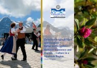
Einzigartige Gebirgslandschaft<br />
Das <strong>UNESCO</strong> <strong>Welterbe</strong> <strong>Schweizer</strong> <strong>Alpen</strong> <strong>Jungfrau</strong>-Aletsch umfasst<br />
mit einer Fläche von 824 km 2 nahezu die gesamten Berner Hochalpen<br />
mit ihren monumentalen Felsmassiven auf dem Gebiet der Kantone Bern<br />
und Wallis. Rund 90 Prozent der Fläche des <strong>Welterbe</strong>s sind von Fels<br />
und von Eis bedeckt. Das <strong>Welterbe</strong> <strong>Welterbe</strong> <strong>Schweizer</strong> <strong>Alpen</strong> <strong>Jungfrau</strong>-<br />
Aletsch steht für die wunderbaren Naturschönheiten der <strong>Alpen</strong>. Das<br />
Zentrum bildet das gewaltige Felsmassiv von Eiger, Mönch und <strong>Jungfrau</strong><br />
mit der Gletscherlandschaft rund um den Grossen Aletschgletscher. An<br />
den Südhängen des Bietschhorns geht die hochalpine Szenerie über die<br />
verschiedenen Vegetationsstufen sanft in eine Felsensteppe mit mediterranem<br />
Charakter über. Diese Vielfalt unterschiedlichster Landschaften und<br />
Ökosysteme verschmilzt zu einem Gesamtbild von aussergewöhnlicher<br />
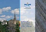
Schönheit. In einer Charta erklären die 25 beteiligten Gemeinden, das<br />
<strong>Welterbe</strong>gebiet den zukünftigen Generationen in seiner ästhetischen Vielfalt<br />
und Einzigartigkeit zu bewahren.<br />
Die grandiose Hochgebirgslandschaft um <strong>Jungfrau</strong>, Aletsch- und Bietschhorn<br />
erfüllt in besonderer Weise die vom <strong>Welterbe</strong>komitee verlangten<br />
Attribute wie aussergewöhnlich, überragend und universell. Seit dem<br />
Dezember 2001 gehört das Gebiet zum exklusiven Club der <strong>UNESCO</strong><br />
<strong>Welterbe</strong>stätten. In der Liste figurieren so einzigartige Naturphänomene<br />
wie der Yellowstone-Nationalpark, die Serengeti, die Galapagosinseln<br />
oder so unersetzliche Zeugnisse der Menschheit wie die Heiligtümer<br />
von Taishan, die Tempel von Abu Simbel oder das griechische Olympia.<br />
Die Schweiz weist neun <strong>Welterbe</strong>stätten auf: <strong>Schweizer</strong> <strong>Alpen</strong> <strong>Jungfrau</strong>-Aletsch,<br />
Altstadt von Bern, Klosterbezirk St. Gallen, Benediktinerkloster<br />
St. Johann in Müstair, Tre Castelli in Bellinzona, Monte San Giorgio<br />
im Tessin, Lavaux Weinberg-Terrassen, <strong>Schweizer</strong> Tektonikarena<br />
Sardona und Räthische Bahn in der Landschaft Albula ⁄ Bernina.<br />
Das <strong>Welterbe</strong>gebiet <strong>Schweizer</strong> <strong>Alpen</strong> <strong>Jungfrau</strong>-Aletsch ist geprägt von<br />
landschaftlichen Gegensätzen und gehört weltweit zu den grossartigsten<br />
Gebirgslandschaften. Auf der Berner Seite geht die grüne und vielfältige<br />
Kulturlandschaft abrupt in die gigantische Mauer aus Fels und Eis von<br />
Eiger, Mönch und <strong>Jungfrau</strong> über. Keine andere Region verkörpert die <strong>Alpen</strong><br />
in ihrer ursprünglichsten Form wie das <strong>Jungfrau</strong>massiv mit seiner<br />
herben Schönheit. Noch immer umgibt ein starker Mythos die mächtige<br />
Eigernordwand.<br />
Vom <strong>Jungfrau</strong>gebiet zieht sich der Aletschgletscher weit ins Rhonetal<br />
hinunter. Seine klassisch geschwungenen Moränen geben ihm sein unverwechselbares<br />
Aussehen. Gegen das Ende des Gletschers hin sticht<br />
ein aussergewöhnlicher Farbkontrast ins Auge. Die grau-weissen Farben<br />
des Gletschers zeichnen mit dem satten Grün des darüber liegenden<br />
Aletschwaldes ein grossartiges Naturgemälde.<br />
Im Westen bietet die Blüemlisalp mit ihren Nachbarn Wyssi Frau und<br />
Morgenhorn einen imposanten Anblick. Die mächtigen Eis- und Firnpanzer<br />
schliessen das Kiental und das Kandertal ab. Senkrechte Felswände<br />
fallen zum idyllisch gelegenen Oeschinensee ab.<br />
Wie die Finger einer Hand umschliessen fünf Gebirgstäler das Bietschhorn.<br />
An der Südabdachung herrschen ganz andere klimatische Bedingungen<br />
als in den Gipfel- und Gletscherregionen. Trockenheit und starke<br />
Sonneneinstrahlung verleihen der Landschaft ein mediterranes Gepräge.<br />
Lötschen-, Joli-, Bietsch-, Baltschieder- und Gredetschtal haben ihre Ursprünglichkeit<br />
weitgehend bewahren können. Abseits der grossen Touristenströme<br />
finden sich Stille und Beschaulichkeit entlang der Bergbäche<br />
und Suonen.<br />
Im Osten ist fast das gesamte Aarmassiv bis zur Grimsel im <strong>Welterbe</strong> integriert.<br />
Schreckhorn, Lauteraarhorn, das filigrane Finsteraarhorn und das<br />
Oberaarhorn gehören ebenso dazu wie weiter nördlich das markante<br />
Wetterhorn, der Rosenlauigletscher und die Engelhörner.<br />
<strong>Jungfrau</strong>joch – Top of Europe<br />
Der Bau der Zahnradbahn auf das <strong>Jungfrau</strong>joch im ausgehenden<br />
19. Jahrhundert gehört zu den Pioniertaten im weltweiten Eisenbahnbau.<br />
In einem weiten Bogen verläuft das Trassee fast vollständig durch das<br />
Berginnere von Eiger und Mönch. Nach riesigen Anstrengungen erreichten<br />
die Bahnbauer nach 16 Jahren Bauzeit das <strong>Jungfrau</strong>joch mit dem<br />
höchstgelegenen Bahnhof Europas auf 3454 Meter über Meer. Dadurch<br />
kann das <strong>Jungfrau</strong>joch heute auch für Nichtalpinisten von Lauterbrunnen<br />
und Grindelwald aus in etwa 1,5 Stunden Bahnfahrt erreicht werden.<br />
<strong>Jungfrau</strong> mit Sphinx-Observatorium 3561 m ü. M. und dem grossen Aletschgletscher<br />
<strong>Jungfrau</strong>joch with the Sphinx-Observatory and the Great Aletschgletscher<br />
Berühmteste Nordwand<br />
Die senkrecht über Grindelwald aufsteigende Eigernordwand zieht<br />
alle in ihren Bann. Bis heute hat sie für Bergsteiger nichts von ihrem Mythos<br />
als Wand der Wände verloren. Erst 1938 fanden die deutschen Alpinisten<br />
Andreas Heckmair und Ludwig Vörg, zusammen mit den Österreichern<br />
Heinrich Harrer und Fritz Kasparek, eine Route durch die Wand<br />
auf den Eigergipfel.<br />
Längster <strong>Alpen</strong>gletscher<br />
Der Grosse Aletschgletscher ist mit 23 Kilometern Länge und einer<br />
Eisfläche von über 80 km 2 der längste Gletscher der <strong>Alpen</strong>. Im Herzen<br />
des Gletschers, am Konkordiaplatz, ist das Eis über 900 Meter dick. Mit<br />
einer Fliessgeschwindigkeit von rund 180 Metern pro Jahr schiebt sich<br />
der Aletschgletscher talwärts. Von der Belalp her erinnert der Eisstrom<br />
an ein mächtiges Reptil, welches sich aus den Bergflanken zwängt und<br />
zu Tale windet. Wie allen Gletschern, macht die Klimaerwärmung auch<br />
dem Eisriesen schwer zu schaffen. Jährlich zieht sich der Aletschgletscher<br />
zwischen 30 und 75 Meter zurück.<br />
Aletschwald<br />
Am Ende des Aletschgletschers breitet sich der Aletschwald mit seinem<br />
einzigartigen Arvenbestand aus. Niedrige Temperaturen, scharfe<br />
Winde und lange Winter lassen die Bäume nur langsam wachsen. Dafür<br />
kompensieren die Arven das langsame Wachstum mit einem umso längeren<br />
Leben: 600 bis 700 Jahre sind keine Seltenheit. Am Aletschwald<br />
auf der Riederfurka betreibt Pro Natura ein Informations- und Naturschutzzentrum.<br />
Suonen – die Lebensadern<br />
Die Bewohner der niederschlagsarmen Gebiete an den südexponierten<br />
Hängen des Wallis müssen sich seit Jahrhunderten mit der Trockenheit<br />
arrangieren. In künstlich angelegten Kanälen, den Suonen, zweigen<br />
die Walliser das Wasser von den Gletscherbächen ab und leiten es auf<br />
die Felder und Matten. Die Wyssa im Gredetschtal oder die Niwärch-<br />
Suone im Baltschiedertal sind eindrückliche Beispiele für den Kampf um<br />
das überlebenswichtige Nass.<br />
Tal der Wasserfälle<br />
Vom <strong>Jungfrau</strong>massiv fallen die Felswände fast senkrecht auf den<br />
Grund des Lauterbrunnentals ab. Auf wenigen Kilometern Horizontaldistanz<br />
sind riesige Höhenunterschiede von bis zu 3200 Metern zu verzeichnen.<br />
Hier schiesst das Regen- und Schmelzwasser in imposanten<br />
Wasserfällen über bis zu 700 Meter hohe Felsstufen. Zu den berühmtesten<br />
zählen die Trümmelbachfälle.<br />
Quellgebiet der Aare<br />
Das Grimselgebiet schliesst das <strong>Welterbe</strong> im Osten ab. Vom Grimsel-Hospiz<br />
an der gleichnamigen Passstrasse führt ein Wanderweg auf<br />
der Nordseite des Grimselsees durch eine dynamische Moorlandschaft<br />
zu den Aargletschern. Hier liegt das Quellgebiet der Aare mit seiner ausserordentlichen<br />
Bedeutung als Wasserspeicher. Der Unteraargletscher<br />
gilt zudem als Wiege der Gletscherforschung.<br />
Welt der Kristalle<br />
Die Kristallkluft Gerstenegg zeigt die faszinierende Welt der Kristalle<br />
in ihrer natürlichen Form. Sie liegt rund 1,5 Kilometer im Innern des<br />
Grimselmassivs. Die Kluft wurde 1974 beim Kraftwerksbau entdeckt und<br />
kann im Rahmen von Werksbesichtigungen besucht werden.<br />
Oeschinensee<br />
Entstanden ist der Oeschinensee oberhalb von Kandersteg durch einen<br />
Bergsturz und verdient sich den Namen Bergsee aufgrund seiner<br />
Lage ganz besonders. Im Osten und Süden reichen die steilen Wände<br />
der Dreitausender Blüemlisalp, Oeschinenhorn, Fründenhorn und Doldenhorn<br />
fast bis an den Seespiegel hinunter. Gespiesen von Gletscherbächen<br />
hat der See einen unterirdischen Abfluss in den Öschibach.<br />
Öffentlicher Verkehr im <strong>Welterbe</strong><br />
Besuchen Sie das <strong>Welterbe</strong> mit dem öffentlichen Verkehr. Das<br />
<strong>Welterbe</strong>-Gebiet verfügt über eine ausgezeichnete Anbindung an<br />
das nationale und internationale Schienennetz. Sie erreichen die<br />
schönsten Punkte über ein dichtes Netz von Eisenbahn, Buslinien<br />
und Seilbahnen. Dank dem neuen Lötschberg-Basistunnel rückt<br />
die Südseite der <strong>UNESCO</strong>-<strong>Welterbe</strong>stätte fast eine Stunde näher an<br />
die Deutschschweiz. Die Matterhorn Gotthard Bahn (MGB) fährt<br />
stündlich über die berühmte Glacier-Express Strecke in die Region<br />
am Grossen Aletschgletscher. Eine grosse Angebotsvielfalt enthält<br />
die attraktive Erlebnis Card (www.mgbahn.ch) oder der Reagionalpass<br />
Berner Oberland (www.regiopass-berneroberland.ch).<br />
Baltschiedertal | Baltschieder Valley<br />
A Unique Mountain Landscape<br />
Covering an area of 824 square kilometres, the Swiss Alps <strong>Jungfrau</strong>-<br />
Aletsch <strong>UNESCO</strong> World Natural Heritage Site contains nearly all of the<br />
Bernese High Alps, with their monumental rock massifs, in the Cantons<br />
of Berne and Valais. Around 90 percent of this area is covered with rocks<br />
and ice. The Swiss Alps <strong>Jungfrau</strong>-Aletsch World Heritage Site stands for the<br />
splendid natural beauty of the Alps. At its heart lies the impressive Eiger,<br />
Mönch and <strong>Jungfrau</strong> rock massif and the glacial landscape surrounding<br />
the Great Aletsch Glacier. On the southern slopes of the Bietschhorn,<br />
this high-alpine scenery is gradually transformed, over different altitudinal<br />
vegetation zones, into a submediterranean rocky steppe. This rich<br />
diversity of landscapes and ecosystems merges into an overall picture of<br />
outstanding beauty. The 25 participating communes have signed a charter<br />
that declares their commitment to preserving the aesthetic diversity and<br />
uniqueness of the World Heritage Site for future generations.<br />
The magnificent high-mountain landscape around the <strong>Jungfrau</strong>, Aletschhorn<br />
and Bietschhorn offers particular attributes required by the World<br />
Heritage Committee – such as “extraordinary”, “outstanding” and “universal”.<br />
In December 2001 the area became a member of the exclusive<br />
club of <strong>UNESCO</strong> World Heritage Sites, joining unique natural phenomena<br />
such as the Yellowstone National Park, the Serengeti, and the Galapagos<br />
Islands, as well as irreplaceable monuments of human endeavour such as<br />
the shrines of Taishan, the temples of Abu Simbel, and the archaeological<br />
site of Olympia in Greece. At present, Switzerland hosts a total of nine<br />
World Heritage Sites: Swiss Alps <strong>Jungfrau</strong>-Aletsch, the Old City of Berne,<br />
the Convent of St Gall, the Benedictine Convent of St John at Müstair in<br />
the Grisons, the Three Castles of Bellinzone, Monte San Giorgio in the<br />
Ticino, the Vineyard Terraces, Lavaux, the Swiss Tectonic Arena Sardona<br />
as well as the Rhaetian Railway in the Albula ⁄ Bernina Landscapes.<br />
The Swiss Alps <strong>Jungfrau</strong>-Aletsch World Heritage Site is marked by scenic<br />
contrasts and is among to the world’s most magnificent mountain landscapes.<br />
On the Bernese side, the diverse green cultural landscape ends<br />
abruptly in the gigantic wall of rock and ice of the Eiger, Mönch and<br />
<strong>Jungfrau</strong>. No other region embodies the Alps in their most original form<br />
the way the <strong>Jungfrau</strong> massif in its austere beauty does. The mighty north<br />
face of the Eiger continues to hold a strong mystique.<br />
From the <strong>Jungfrau</strong> area, the Great Aletsch Glacier extends far down into the<br />
Rhone Valley. Its classically curved moraines lend the glacier its unmistakable<br />
appearance. Towards the glacier tongue, an unusual contrast of colours<br />
catches the eye: together, the gray-white colours of the glacier and the deep<br />
green of the Aletsch Forest above it form a splendid natural panorama.<br />
To the west, the Blüemlisalp and its neighbouring mountains, the Wyssi<br />
Frau and the Morgenhorn, offer an impressive view. Their mighty coats of<br />
ice and firn close off the Kien and Kander Valleys, and their perpendicular<br />
rock faces descend to the idyllic Oeschinen Lake.<br />
Five mountain valleys extend from the Bietschhorn like the fingers of<br />
a hand. The climatic conditions on the southern slopes are completely<br />
different from those in the area of the summit and glaciers: aridity and<br />
strong solar radiation lend the landscape a Mediterranean touch. The<br />
Lötschen, Joli, Bietsch, Baltschieder and Gredetsch valleys have largely<br />
been able to preserve their original character. Off the beaten tracks of the<br />
main tourist routes, they offer peace and tranquillity along the suonen<br />
and mountain streams.<br />
To the east, the World Heritage Site includes nearly the entire Aar Massif<br />
as far as the Grimsel: the Schreckhorn, the Lauteraarhorn, the delicate and<br />
slender Finsteraarhorn and the Oberaarhorn, as well as the striking Wetterhorn,<br />
the Rosenlaui Glacier, and the Engelhörner further to the north.<br />
<strong>Jungfrau</strong>joch – Top of Europe<br />
The construction of the cog railway to the <strong>Jungfrau</strong>joch at the end of<br />
the 19th century was one of the pioneering feats of worldwide railway<br />
construction. Making a large curve, the tracks run almost completely<br />
through the interior of the Eiger and the Mönch. After 16 years of enormous<br />
effort, the railway builders reached the <strong>Jungfrau</strong>joch, which now<br />
has the highest railway station in Europe at an altitude of 3454 metres<br />
above sea level. The railway enables the general public to access the<br />
<strong>Jungfrau</strong>joch from Lauterbrunnen and Grindelwald in a train ride of<br />
about 1.5 hours.<br />
The Most Famous North Face<br />
Towering vertically above Grindelwald, the impressive rock wall of the<br />
Eiger north face never fails to fascinate visitors. To this day it has not lost<br />
any of its mystique as “the wall of walls” for mountaineers. It was only in<br />
1938 that the first alpinists, the Germans Andreas Heckmair and Ludwig<br />
Vörg and the Austrians Heinrich Harrer and Fritz Kasparek, discovered a<br />
route through the north face to the summit of the Eiger.<br />
The Longest Glacier in the Alps<br />
At a length of 23 kilometres and with a surface of over 80 square<br />
kilometres, the Great Aletsch Glacier is the longest glacier in the Alps.<br />
At its heart, on the vast snowfield of the Konkordiaplatz, the ice cover<br />
is over 900 metres thick. The ice moves down the valley at a rate of 180<br />
metres per year. Viewed from Belalp, the glacier resembles a huge reptile<br />
winding its way out frombetween the slopes down towards the main valley.<br />
Like all glaciers, this giant, too, is suffering from climate change. Due<br />
to global warming, the glacier is currently receding by 30 to 75 metres<br />
every year.<br />
The Aletsch Forest<br />
The Aletsch Forest, with its unique population of Swiss stone pine<br />
(Pinus cembra), extends around the tongue of the Aletsch Glacier. Low<br />
temperatures, piercing winds and long winter seasons limit the growth<br />
rate of the trees. Swiss stone pines compensate for their slow growth with<br />
particularly long lives, frequently reaching an age of 600 to 700 years. At<br />
Riederfurka, next to the Aletsch Forest, Pro Natura runs an information<br />
and conservation centre.<br />
Suonen: Vital Irrigation Channels<br />
The inhabitants of areas with little precipitation on the south-facing<br />
slopes of the Valais have had to cope with aridity for centuries. Through<br />
man-made channels called suonen, they divert water from glacial streams<br />
to their fields and meadows. The Wyssa suone in the Gredetsch Valley<br />
and the Niwärch suone in the Baltschieder Valley are fascinating testimonies<br />
to the struggle for vital water.<br />
Valley of Waterfalls<br />
The rock faces of the <strong>Jungfrau</strong> massif drop almost vertically to the<br />
bottom of the Lauterbrunnen Valley. Huge vertical differences of up to<br />
3200 metres occur within a short horizontal distance of a few kilometres.<br />
Rainwater and melted snow and ice combine to form impressive<br />
waterfalls leaping over cliffs up to 700 metres high. Among the most<br />
famous are the Trümmelbach Falls.<br />
The Aare Headwaters<br />
The Grimsel area forms the eastern border of the World Heritage<br />
Site. From the Grimsel Hospice and the Grimsel Pass Road, a hiking trail<br />
runs through a dynamic mire landscape to the Aare glaciers north of the<br />
Grimsel Lake. These are the headwaters of the Aare River. In addition to<br />
their extraordinary significance with regard to water storage, the Unteraar<br />
Glacier is also regarded as the cradle of glaciology.<br />
World of Crystals<br />
The crystal cleft at Gerstenegg displays the fascinating world of crystals<br />
in their natural form. The cavern is situated about 1.5 kilometres<br />
inside the Grimsel Massif. It was discovered in 1974 during construction<br />
work for a hydropower station and now constitutes one of the main attractions<br />
on the guided tour of the power station.<br />
Die Kristallkluft Gerstenegg zeigt die faszinierende Welt der Kristalle<br />
The crystal cleft at Gerstenegg displays the fascinating world of crystals<br />
Oeschinen Lake<br />
Formed long ago after a rock fall, the Oeschinen Lake above Kandersteg<br />
is particularly worthy of being called a mountain lake. To the east<br />
and the south, the steep rock faces of the Blüemlisalp, Oeschinenhorn,<br />
Fründenhorn and Doldenhorn – all three-thousand-metre peaks – reach<br />
nearly all the way down to the lake surface. The lake is fed from glacial<br />
streams and drains through a subterranean outlet into the Oeschibach<br />
River.<br />
Public Transport in the World Heritage Site<br />
The most convenient way to visit the World Heritage Site is<br />
to use public transport. The area is well connected to the national<br />
and international railway network. Within the WHS, a close-knit<br />
network of railway, bus and cable car lines provides access to the<br />
most spectacular locations. Thanks the new Lötschberg base tunnel<br />
the trip from the southern slopes of the <strong>UNESCO</strong> World Heritage<br />
Site to the German-speaking part of Switzerland has been shortened<br />
almost by an hour. Every hour a train runs along the famous<br />
Glacier Express line towards the Great Aletsch Glacier. The Erlebnis<br />
Card (www.mgbahn.ch) and the Regionalpass Berner Oberland<br />
(www.regiopass-berneroberland.ch) offers a rich and varied choice<br />
of destinations.<br />
Mit finanzieller Unterstützung durch:<br />
Bundesamt für Umwelt (BAFU) / seco ihm Rahmen von Regio Plus / Lotteriefonds<br />
des Kantons Bern / Kanton Wallis / Gemeinden und Trägerschaft <strong>Welterbe</strong> <strong>Schweizer</strong><br />
<strong>Alpen</strong> <strong>Jungfrau</strong>-Aletsch / Grimselwelt / Belalp Bahnen AG / Aletscharena / Matterhorn<br />
Gotthard Bahn / <strong>Schweizer</strong> <strong>Alpen</strong>-Club SAC<br />
With financial support from:<br />
Swiss Agency for the Environment, Forests and Landscape / seco, within the framework<br />
of Regio Plus / Lottery Fund of the Canton of Berne / Canton of Valais / Perimeter<br />
communes and Swiss Alps <strong>Jungfrau</strong>-Aletsch World Heritage Asscociation / Grimselwelt<br />
/ Belalp Bahnen AG / Aletscharena / Matterhorn Gotthard Bahn / Swiss Alpine<br />
Club (SAC)<br />
Erstes <strong>UNESCO</strong><br />
Weltnaturerbe der <strong>Alpen</strong><br />
First <strong>UNESCO</strong><br />
World Natural Heritage<br />
Site in the Alps<br />
Deutsch | English<br />
Oeschinensee bei Kandersteg | Oeschinen Lake above Kandersteg<br />
Kühmad im Lötschental | Kühmad in the Lötschen Valley<br />
Wandern entlang der Suonen | Wandern entlang der Suonen<br />
Hinteres Lauterbrunnental mit Breithorn und Tschingelhorn<br />
Upper Lauterbrunnen Valley with the Breithorn and the Tschingelhorn<br />
Die BLS AG verbindet die <strong>UNESCO</strong>-Weltkulturerbestätte der Altstadt Bern mit der<br />
<strong>UNESCO</strong>-Weltnaturerbestätte in den <strong>Alpen</strong>.<br />
The BLS AG connects the old city of Bern, a <strong>UNESCO</strong> World Cultural Heritage Site,<br />
to the <strong>UNESCO</strong> World Natural Heritage Site in the Alps.
Perimetergemeinden | Perimeter Communes<br />
Ausserberg<br />
www.ausserberg.ch<br />
Fläche | Surface Area: 14,9 km 2<br />
im <strong>Welterbe</strong> | Inside the WHS: 66,4 %<br />
Einwohnerzahl | Inhabitants: 662<br />
Tourismus | Tourism organisation:<br />
Sonnige Halden am Lötschberg<br />
Baltschieder<br />
www.baltschieder.ch<br />
Fläche | Surface Area: 31,4 km 2<br />
im <strong>Welterbe</strong> | Inside the WHS: 92,6 %<br />
Einwohnerzahl | Inhabitants: 1200<br />
Tourismus | Tourism organisation:<br />
Sonnige Halden am Lötschberg<br />
Bellwald<br />
www.bellwald.ch<br />
Fläche | Surface Area: 13,7 km 2<br />
im <strong>Welterbe</strong> | Inside the WHS: 16,4 %<br />
Einwohnerzahl | Inhabitants: 444<br />
Tourismus | Tourism organisation:<br />
Bellwald Tourismus<br />
Betten-Bettmeralp<br />
www.bettmeralp.ch<br />
Fläche | Surface Area: 26,4 km 2<br />
im <strong>Welterbe</strong> | Inside the WHS: 67,4 %<br />
Einwohnerzahl | Inhabitants: 410<br />
Tourismus | Tourism organisation:<br />
Bettmeralp Tourismus<br />
Birgisch<br />
www.birgisch.ch<br />
Fläche | Surface Area: 5,8 km 2<br />
im <strong>Welterbe</strong> | Inside the WHS: 6,1 %<br />
Einwohnerzahl | Inhabitants: 230<br />
Tourismus | Tourism organisation:<br />
Brig Belalp Tourismus<br />
Blatten (Lötschen)<br />
www.loetschental.ch<br />
Fläche | Surface Area: 90,6 km 2<br />
im <strong>Welterbe</strong> | Inside the WHS: 90,9 %<br />
Einwohnerzahl | Inhabitants: 324<br />
Tourismus | Tourism organisation:<br />
Lötschental Tourismus<br />
Eggerberg<br />
www.eggerberg.ch<br />
Fläche | Surface Area: 5,9 km 2<br />
im <strong>Welterbe</strong> | Inside the WHS: 36,6 %<br />
Einwohnerzahl | Inhabitants: 354<br />
Tourismus | Tourism organisation:<br />
Sonnige Halden am Lötschberg<br />
Ferden<br />
www.loetschental.ch<br />
Fläche | Surface Area: 27,9 km 2<br />
im <strong>Welterbe</strong> | Inside the WHS: 14,3 %<br />
Einwohnerzahl | Inhabitants: 300<br />
Tourismus | Tourism organisation:<br />
Lötschental Tourismus<br />
Fieschertal<br />
www.fieschertal.ch<br />
Fläche | Surface Area: 173 km 2<br />
im <strong>Welterbe</strong> | Inside the WHS: 92,3 %<br />
Einwohnerzahl | Inhabitants: 310<br />
Tourismus | Tourism organisation:<br />
Eggishorn Tourismus<br />
Kippel<br />
www.kippel.ch<br />
Fläche | Surface Area: 11,7 km 2<br />
im <strong>Welterbe</strong> | Inside the WHS: 49,1 %<br />
Einwohnerzahl | Inhabitants: 400<br />
Tourismus | Tourism organisation:<br />
Lötschental Tourismus<br />
Mund<br />
www.mund.ch<br />
Fläche | Surface Area: ca. 40,1 km 2<br />
im <strong>Welterbe</strong> | Inside the WHS: 82,7 %<br />
Einwohnerzahl | Inhabitants: 534<br />
Tourismus | Tourism organisation:<br />
Brig Belalp Tourismus<br />
Gemeinde Naters<br />
www.naters.ch<br />
Fläche | Surface Area: 101,2 km 2<br />
im <strong>Welterbe</strong> | Inside the WHS: 66,9 %<br />
Einwohnerzahl | Inhabitants: 8200<br />
Tourismus | Tourism organisation:<br />
Brig Belalp Tourismus<br />
Niedergesteln<br />
www.niedergesteln.ch<br />
Fläche | Surface Area: 17,4 km 2<br />
im <strong>Welterbe</strong> | Inside the WHS: 69,6 %<br />
Einwohnerzahl | Inhabitants: 650<br />
Tourismus | Tourism organisation:<br />
Raron-Niedergesteln Tourismus<br />
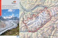
Besonderheiten | Points of Interest<br />
1. Gasterental | Gasteren Valley<br />
2. um Doldenhornhütte, Fisistöcke & Jegertosse<br />
Surroundings of the Doldenhornhütte,<br />
Fisistöcke & Jegertosse<br />
3. Oeschinensee | Oeschinen Lake<br />
4. Gletschervorfeld Gamchi<br />
Gamchi glacier foreland<br />
5. Hinteres Lauterbrunnental<br />
Upper Lauterbrunnen Valley<br />
6. Trümmelbachfälle | Trümmelbach Falls<br />
7. <strong>Jungfrau</strong>joch<br />
8. Eigernordwand | Eiger north face<br />
9. Gletscherschlucht | Glacier Gorge Grindelwald<br />
Raron<br />
www.raron.ch<br />
Fläche | Surface Area: 30,3 km 2<br />
im <strong>Welterbe</strong> | Inside the WHS: 71 %<br />
Einwohnerzahl | Inhabitants: 1825<br />
Tourismus | Tourism organisation:<br />
Raron-Niedergesteln Tourismus<br />
Riederalp<br />
www.gemeinde-riederalp.ch<br />
Fläche | Surface Area: 21 km 2<br />
im <strong>Welterbe</strong> | Inside the WHS: 28,4 %<br />
Einwohnerzahl | Inhabitants: 531<br />
Tourismus | Tourism organisation:<br />
Riederalp-Mörel Tourismus<br />
Steg-Hohtenn<br />
www.steg-hohtenn.ch<br />
Fläche | Surface Area: 14,2 km 2<br />
im <strong>Welterbe</strong> | Inside the WHS: 66,9 %<br />
Einwohnerzahl | Inhabitants: 1640<br />
Tourismus | Tourism organisation:<br />
Sonnige Halden am Lötschberg<br />
Wiler<br />
www.wilervs.ch<br />
Fläche | Surface Area: 14,7 km 2<br />
im <strong>Welterbe</strong> | Inside the WHS: 42 %<br />
Einwohnerzahl | Inhabitants: 533<br />
Tourismus | Tourism organisation:<br />
Lötschental Tourismus<br />
Grindelwald<br />
www.grindelwald.ch<br />
Fläche | Surface Area: 171,1 km 2<br />
im <strong>Welterbe</strong> | Inside the WHS: 43,7 %<br />
Einwohnerzahl | Inhabitants: 4173<br />
Tourismus | Tourism organisation:<br />
Grindelwald Tourismus<br />
Guttannen<br />
www.guttannen.ch<br />
Fläche | Surface Area: 200,8 km 2<br />
im <strong>Welterbe</strong> | Inside the WHS: 46,6 %<br />
Einwohnerzahl | Inhabitants: 320<br />
Tourismus | Tourism organisation:<br />
Haslital Tourismus<br />
Innertkirchen<br />
www.innertkirchen.ch<br />
Fläche | Surface Area: 120,1 km 2<br />
im <strong>Welterbe</strong> | Inside the WHS: 4,8 %<br />
Einwohnerzahl | Inhabitants: 918<br />
Tourismus | Tourism organisation:<br />
Haslital Tourismus<br />
Kandersteg<br />
www.kandersteg.ch<br />
Fläche | Surface Area: 134,6 km 2<br />
im <strong>Welterbe</strong> | Inside the WHS: 52,1 %<br />
Einwohnerzahl | Inhabitants: 1249<br />
Tourismus | Tourism organisation:<br />
Kandersteg Tourismus<br />
Lauterbrunnen<br />
www.lauterbrunnen.ch<br />
Fläche | Surface Area: 164,6 km 2<br />
im <strong>Welterbe</strong> | Inside the WHS: 54 %<br />
Einwohnerzahl | Inhabitants: 3000<br />
Tourismus | Tourism organisation:<br />
<strong>Jungfrau</strong> Region Marketing AG<br />
Meiringen<br />
www.meiringen.ch<br />
Fläche | Surface Area: 40,6 km 2<br />
im <strong>Welterbe</strong> | Inside the WHS: 4,4 %<br />
Einwohnerzahl | Inhabitants: 4682<br />
Tourismus | Tourism organisation:<br />
Haslital Tourismus<br />
Reichenbach i. K.<br />
www.reichenbach.ch<br />
Fläche | Surface Area: 125,7 km 2<br />
im <strong>Welterbe</strong> | Inside the WHS: 10,2 %<br />
Einwohnerzahl | Inhabitants: 3417<br />
Tourismus | Tourism organisation:<br />
Kiental-Reichenbach Tourismus<br />
Schattenhalb<br />
www.schattenhalb.ch<br />
Fläche | Surface Area: 31,5 km 2<br />
im <strong>Welterbe</strong> | Inside the WHS: 20,2 %<br />
Einwohnerzahl | Inhabitants: 620<br />
Tourismus | Tourism organisation:<br />
Haslital Tourismus<br />
www.jungfraualetsch.ch<br />
SAC Hütten und Berghäuser<br />
SAC Huts and Mountain Guesthouses<br />
Insgesamt befinden sich 39 Hütten<br />
und Berghäuser im Perimeter des<br />
<strong>UNESCO</strong> <strong>Welterbe</strong>s. 23 davon<br />
unterhält der <strong>Schweizer</strong> <strong>Alpen</strong>club<br />
(SAC): www.sac-cas.ch<br />
There are 39 Alpine huts and mountain<br />
guesthouses within the perimeter<br />
of the <strong>UNESCO</strong> World Heritage<br />
Site. 23 of them are operated by the<br />
Swiss Alpine Club (SAC):<br />
www.sac-cas.ch<br />
1. Doldenhornhütte SAC<br />
www.doldenhornhuette.ch<br />
aschi.mueller@bluewin.ch<br />
+41 (0)33 675 16 60<br />
2. Fründenhütte SAC<br />
+41 (0)33 675 14 33<br />
3. Blüemlisalphütte SAC<br />
www.bluemlisalphuette.com<br />
info@bluemlisalphuette.com<br />
+41 (0)33 676 14 37<br />
4. Mutthornhütte SAC<br />
www.mutthornhuette.ch<br />
mutthornhuette@bluewin.ch<br />
+41 (0)33 853 13 44<br />
5. Gspaltenhornhütte SAC<br />
www.gspaltenhornhuette.ch<br />
info@gspaltenhornhuette.ch<br />
+41 (0)33 676 16 29<br />
6. Schmadrihütte AACB<br />
www.aacb.ch/schmadri<br />
Hüttenwart: +41 (0)33 855 23 65<br />
7. Hotel Obersteinberg<br />
www.stechelberg.ch<br />
+41 (0)33 855 33 01<br />
8. Berggasthaus Tschingelhorn<br />
www.tschingelhorn.ch<br />
+41 (0)33 855 13 43<br />
9. Berggasthaus Trachsellauenen<br />
+41 (0)33 855 12 35<br />
10. Rottalhütte SAC<br />
www.sac-interlaken.ch<br />
rottalhuette@sac-interlaken.ch<br />
+41 (0)33 822 47 39<br />
11. Silberhornhütte SAC<br />
www.vs-wallis.ch/bern/huetverz/<br />
silberhorn.html<br />
12. Guggihütte SAC<br />
www.sac-interlaken.ch<br />
+41 (0)33 855 33 60<br />
13. Mönchsjochhütte<br />
www.moenchsjoch.ch<br />
info@moenchsjoch.ch<br />
+41 (0)33 971 34 72<br />
14. Berglihütte SAC<br />
www.sac-grindelwald.ch<br />
heinz.inaebnit@jungfrau.ch<br />
Hüttenwart: +41 (0)33 828 78 13<br />
15. Mittellegihütte<br />
www.vs-wallis.ch/bern/huetverz/<br />
mittellegi.html<br />
gomountain@grindelwald.ch<br />
+41 (0)33 853 03 66<br />
16. Ostegghütte<br />
info@grindelwaldsports.ch<br />
Schlüssel: +41 (0)33 854 12 90<br />
17. Berghaus Bäregg<br />
www.baeregg.com<br />
info@baeregg.com<br />
+41 (0)33 853 43 14<br />
18. Schreckhornhütte SAC<br />
www.sac-basel.ch<br />
+41 (0)33 853 33 74<br />
19. Glecksteinhütte SAC<br />
www.gleckstein.ch<br />
info@gleckstein.ch<br />
+ 41 (0)33 853 11 40<br />
10. Gletscherschlucht Rosenlaui<br />
Rosenlaui Glacier Gorge<br />
11. Schwemmebene Bächlital<br />
Bächlital alpine alluvial zone<br />
12. Quellgebiet der Aare<br />
Headwaters of the Aare River<br />
13. Märjelensee | Märjelen Lake<br />
14. Eggishorn<br />
15. Bettmerhorn<br />
16. Aletschwald | Aletsch Forest<br />
17. Belalp & Aletschbord<br />
18. Gredetschtal | Gredetsch Valley<br />
19. Safranäcker Mund | Saffron fields in Mund<br />
20. Dossenhütte SAC<br />
www.dossenhuette.ch<br />
cyzwicky@bluewin.ch<br />
+41 (0)33 971 44 94<br />
21. Engelhornhütte AACB<br />
www.haslihuetten.ch<br />
c.scheller@gmx.ch<br />
+41 (0)33 971 47 26<br />
22. Gruebenhütte AACB<br />
www.gruebenhuette.ch<br />
silbernagel@bergpunkt.ch<br />
+41 (0)79 263 64 12<br />
23. Bächlitalhütte SAC<br />
www.baechlitalhuette.ch<br />
info@baechlitalhuette.ch<br />
+41 (0)33 973 11 14<br />
24. Lauteraarhütte SAC<br />
www.haslihuetten.ch<br />
lauteraar@sac-zofingen.ch<br />
+41 (0)33 973 11 10<br />
25. Aarbiwak SAC<br />
www.sac-pilatus.ch<br />
brefin@rdx.ch<br />
Hüttenwart: +41 (0)41 710 39 42<br />
26. Oberaarjochhütte SAC<br />
www.sac-biel.ch<br />
+41 (0)33 973 13 82<br />
27. Finsteraarhornhütten SAC<br />
www.finsteraarhornhuette.ch<br />
info@finsteraarhornhuette.ch<br />
+41 (0)33 855 29 55<br />
28. Konkordiahütten SAC<br />
www.konkordiahuette.ch<br />
info@konkordiahuette.ch<br />
+41 (0)33 855 13 94<br />
29. Burghütte<br />
www.burghuette.ch<br />
info@burghuette.ch<br />
+41 (0)27 971 40 27<br />
30. Gletscherstube<br />
www.gletscherstube.ch<br />
aletsch@gletscherstube.ch<br />
+41 (0)27 971 47 83<br />
31. Mittelaletschbiwak SAC<br />
www.cas-diablerets.ch<br />
+41 (0)21 729 85 73<br />
32. Fusshornbiwak<br />
www.alpincenterbelalp.ch<br />
info@alpincenterbelalp.ch<br />
+41 (0)27 921 60 45<br />
33. Oberaletschhütten SAC<br />
www.oberaletsch.ch<br />
info@oberaletsch.ch<br />
+41 (0)27 927 17 67<br />
34. Hollandiahütte SAC<br />
www.hollandiahuette.ch<br />
hollandia@bluewin.ch<br />
+41 (0)27 939 11 35<br />
35. Anenhütte<br />
www.anenhuette.ch<br />
info@anenhuette.ch<br />
+41 (0)79 864 66 44<br />
36. Baltschiederklause SAC<br />
www.rhone.ch/baltschiederklause<br />
+41 (0)27 852 23 65<br />
37. Stockhornbiwak SAC<br />
www.sac-bluemlisalp.ch<br />
+41 (0)27 971 24 04<br />
38. Wiwannihütte<br />
www.wiwanni.ch<br />
info@wiwanni.ch<br />
+41 (0)27 923 09 03<br />
39. Bietschhornhütte AACB<br />
www.aacb.ch/bietschhorn.php<br />
bietschhorn@aacb.ch<br />
+41 (0)79 305 85 94<br />
20. An den heiligen Wassern: Suonen<br />
Along the sacred waterways: Suonen<br />
21. Baltschiedertal | Baltschieder Valley<br />
22. Bietschtal | Bietsch Valley<br />
23. Jolital & Jolischlucht | Joli Valley & Joli Gorge<br />
24. Alpsiedlungen Ladu & Tatz<br />
Alpine settlements of Ladu & Tatz<br />
25. Gattunalpa & Gatunmannli: Rundwanderung &<br />
Aussichtspunkt | Round trip hike & vantage point<br />
26. Kühmad<br />
27. Chrindellücke: Aussichtspunkt | Vantage point<br />
28. Langgletscher, Gletschervorfeld & Anusee<br />
Lang Glacier, glacier foreland & Anu Lake<br />
Managementzentrum | Management Centre<br />
<strong>UNESCO</strong> <strong>Welterbe</strong> | World Heritage Site (WHS)<br />
<strong>Schweizer</strong> <strong>Alpen</strong> <strong>Jungfrau</strong>-Aletsch | Swiss Alps <strong>Jungfrau</strong>-Aletsch<br />
Postfach | P.O. Box 444, CH - 3904 Naters<br />
+41 (0)27 924 52 76<br />
www.jungfraualetsch.ch, info@jungfraualetsch.ch<br />
Tourismusbüros & Destinationen<br />
Tourist Offices & Destinations<br />
Bellwald Tourismus<br />
Dorf, 3997 Bellwald<br />
www.bellwald.ch, info@bellwald.ch<br />
+41 (0)27 971 16 84<br />
Bettmeralp Tourismus<br />
3992 Bettmeralp<br />
www.bettmeralp.ch, info@bettmeralp.ch<br />
+41 (0)27 928 60 60<br />
Brig Belalp Tourismus<br />
3900 Brig<br />
www.brig-belalp.ch, info@brig-belalp.ch<br />
+41 (0)27 921 60 30 / 40<br />
Eggishorn Tourismus<br />
Furkastrasse, 3984 Fiesch<br />
www.fiesch.ch, info@fiesch.ch<br />
+41 (0)27 970 60 70<br />
Goms Tourismus<br />
Furkastrasse, 3984 Fiesch<br />
www.goms.ch, tourismus@goms.ch<br />
+41 (0)27 970 10 70<br />
Grindelwald Tourismus<br />
Postfach 124, 3818 Grindelwald<br />
www.grindelwald.com, touristcenter@grindelwald.ch<br />
+41 (0)33 854 12 12<br />
Haslital Tourismus<br />
Tourist Information Meiringen<br />
Bahnhofstrasse 22, 3860 Meiringen<br />
www.haslital.ch, info@haslital.ch<br />
+41 (0)33 972 50 50<br />
Interlaken Tourismus<br />
Höhenweg 37, 3800 Interlaken<br />
www.interlaken.ch, mail@interlakentourism.ch<br />
+41 (0)33 826 53 00<br />
<strong>Jungfrau</strong> Region Marketing AG<br />
Postfach 131, 3818 Grindelwald<br />
www.myjungfrau.ch, info@myjungfrau.ch<br />
+41 (0)33 854 12 40<br />
Kandersteg Tourismus<br />
3718 Kandersteg<br />
www.kandersteg.ch, info@kandersteg.ch<br />
+41 (0)33 675 80 80<br />
Kiental-Reichenbach Tourismus<br />
Büro Reichenbach<br />
Bahnhofstrasse, 3713 Reichenbach<br />
www.kiental.ch, ferien@reichenbach.ch<br />
+41 (0)33 676 35 35<br />
Büro Kiental<br />
Dorf, 3723 Kiental<br />
www.kiental.ch, ferien@kiental.ch<br />
+41 (0)33 676 10 10<br />
Lötschberg Tourismus<br />
3718 Kandersteg<br />
www.loetschbergregion.ch, info@loetschberg.ch<br />
+41 0848 00 48 00<br />
Lötschental Tourismus<br />
3918 Wiler<br />
www.loetschental.ch, info@loetschental.ch<br />
+41 (0)27 938 88 88<br />
Raron-Niedergesteln Tourismus<br />
Bahnhofstrasse, 3942 Raron,<br />
www.raron-niedergesteln.ch, info@raron-niedergesteln.ch<br />
+41 (0)27 934 31 00<br />
Riederalp-Mörel Tourismus<br />
Bahnhofstrasse, 3987 Riederalp,<br />
www.riederalp.ch, info@riederalp.ch<br />
+41 (0)27 928 60 50<br />
Sonnige Halden am Lötschberg<br />
3939 Eggerberg<br />
www.sonnige-halden.ch, info@sonnige-halden.ch<br />
+41 (0)27 946 63 14<br />
Grimselwelt<br />
3862 Innertkirchen<br />
www.grimselwelt.ch, welcome@grimselwelt.ch<br />
+41 (0)33 982 26 26<br />
Pro Natura Zentrum Aletsch<br />
Villa Cassel, 3987 Riederalp<br />
www.pronatura.ch/aletsch, aletsch@pronatura.ch<br />
+41 (0)27 928 62 20<br />
Impressum<br />
Fotos | Photos: <strong>Jungfrau</strong>bahnen, Allvisions Lorenz Andreas Fischer,<br />
Doris Schmied, Peter Ritler, Lötschberg Tourismus, BLS AG, Ernst Zbären,<br />
KWO, sens’or Gestaltungs-GmbH<br />
Gestaltung | Design: sens’or Gestaltungs-GmbH, Naters, www.sens-or.ch<br />
Druck | Print: Mengis Druck und Verlag AG, Visp<br />
Kartografie | Cartography: Flotron AG, Meiringen<br />
BLS<br />
Naturpark Wallis Pfyn-Finges<br />
REICHENBACH<br />
3<br />
KANDERSTEG<br />
1 2<br />
1<br />
BLS<br />
BLS<br />
SBB<br />
Regionaler Naturpark Thunersee-Hohgant<br />
ZB<br />
BLS<br />
BOB<br />
GRINDELWALD<br />
LAUTERBRUNNEN<br />
6<br />
11<br />
9<br />
8<br />
10<br />
9<br />
16<br />
8 15<br />
12<br />
131<br />
14<br />
7<br />
7 5<br />
4<br />
5<br />
3<br />
6<br />
2<br />
4<br />
34<br />
35<br />
31<br />
28<br />
27<br />
33<br />
26<br />
32<br />
BLATTEN<br />
WILER<br />
KIPPEL<br />
BIETSCHHORN<br />
FERDEN<br />
39<br />
25<br />
37<br />
21<br />
22<br />
23<br />
38<br />
24 20<br />
19<br />
AUSSERBERG<br />
MUND<br />
HOHTENN RARON<br />
BLS<br />
STEG<br />
EGGERBERG<br />
NIEDERGESTELN<br />
BALTSCHIEDER<br />
SBB MGB<br />
MGB<br />
JUNGFRAU<br />
36<br />
16<br />
17<br />
18<br />
ALETSCH<br />
RIEDERALP<br />
MGB<br />
NATERS<br />
BIRGISCH<br />
SBB<br />
28<br />
17<br />
15<br />
13<br />
BETTMERALP<br />
19<br />
Lausanne<br />
Genève<br />
18<br />
30<br />
14<br />
27<br />
29<br />
FIESCHERTAL<br />
Bern<br />
Kandersteg<br />
Sion<br />
ZB<br />
Basel<br />
Brig<br />
25<br />
10<br />
26<br />
21<br />
BELLWALD<br />
MEIRINGEN<br />
SCHATTENHALB<br />
20<br />
Landschaftspark Binntal<br />
Luzern<br />
Interlaken<br />
Spiez<br />
Milano<br />
Zürich<br />
Gotthard<br />
Lugano<br />
Chur<br />
INNERTKIRCHEN<br />
24<br />
12<br />
MGB<br />
RARON<br />
RARON<br />
RARON<br />
11<br />
RARON<br />
11<br />
RARON 11<br />
11<br />
36<br />
RARON<br />
36<br />
RARON<br />
RARON 11 36<br />
RARON<br />
11 36<br />
11<br />
11 36<br />
11<br />
36<br />
36<br />
36<br />
36<br />
BOB<br />
BOB<br />
BOB<br />
BOB<br />
BLS<br />
BLS<br />
BOB BLS<br />
MGB<br />
MGB BOB BLS<br />
MGB<br />
BOB<br />
BOB<br />
BLS<br />
SBB<br />
MGB<br />
SBB<br />
BOB<br />
BLS<br />
MGB SBB<br />
BLS<br />
BLS<br />
ZB<br />
SBB BLS<br />
MGB<br />
ZB<br />
MGB<br />
MGB SBB ZB<br />
MGB ZB<br />
SBB<br />
SBB<br />
SBB ZB<br />
SBB<br />
ZB<br />
ZB<br />
ZB<br />
ZB<br />
22<br />
23<br />
GUTTANNEN<br />
11<br />
Perimeter Weltnaturerbe<br />
Perimeter World Natural Heritage Site<br />
Perimetergemeinde<br />
Perimeter commune<br />
Besonderheit | Point of interest<br />
SAC Hütte / Berghaus<br />
SAC hut / Mountain guesthouse<br />
Postauto | Postbus<br />
Sessellift | Chairlift<br />
Gondelbahn | Gondola lift<br />
Drahtseilbahn | Cable car<br />
Standseilbahn | Funicular<br />
Eisenbahn | Railway<br />
Autoverlad | Car transport by rail<br />
Berner Oberland-Bahn<br />
Bernese Oberland Railway<br />
Lötschbergbahn AG (BLS)<br />
Matterhorn Gotthard Bahn<br />
Matterhorn Gotthard Railway<br />
<strong>Schweizer</strong>ische Bundesbahnen (SBB)<br />
Swiss Federal Railways (SBB)<br />
Zentralbahn<br />
Kartengrundlage: Landeskarte 1:200’000<br />
reproduziert mit Bewilligung von swisstopo<br />
(983-D/15062009)<br />
Cartography: reproduction of a national<br />
map 1:200‘000 enlarged with permission<br />
of swisstopo (983-D/15062009)