Vorlesung ‚Geoinformatik A—Vorlesung ‚Geoinformatik A—
Vorlesung ‚Geoinformatik A—Vorlesung ‚Geoinformatik A—
Vorlesung ‚Geoinformatik A—Vorlesung ‚Geoinformatik A—

Sie wollen auch ein ePaper? Erhöhen Sie die Reichweite Ihrer Titel.
YUMPU macht aus Druck-PDFs automatisch weboptimierte ePaper, die Google liebt.
Volker Hochschild – <strong>Vorlesung</strong> „Geoinformatik A“<br />
____________________________________________________________________________________________________________________________________________________<br />
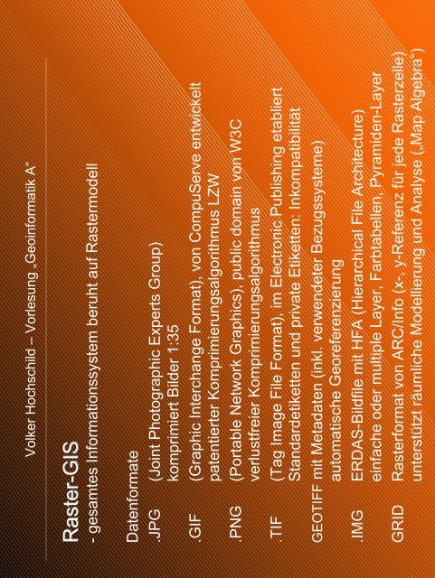
Raster-GIS<br />
- gesamtes Informationssystem beruht auf Rastermodell<br />
Datenformate<br />
.JPG (Joint Photographic Experts Group)<br />
komprimiert Bilder 1:35<br />
.GIF (Graphic Interchange Format), von CompuServe entwickelt<br />
patentierter Komprimierungsalgorithmus LZW<br />
.PNG (Portable Network Graphics), public domain von W3C<br />
verlustfreier Komprimierungsalgorithmus<br />
.TIF (Tag Image File Format), im Electronic Publishing etabliert<br />
Standardetiketten und private Etiketten: Inkompatibilität<br />
GEOTIFF mit Metadaten (inkl. verwendeter Bezugssysteme)<br />
automatische Georeferenzierung<br />
.IMG ERDAS-Bildfile mit HFA (Hierarchical File Architecture)<br />
einfache oder multiple Layer, Farbtabellen, Pyramiden-Layer<br />
GRID Rasterformat von ARC/Info (x-, y-Referenz für jede Rasterzelle)<br />
unterstützt räumliche Modellierung und Analyse („Map Algebra“)