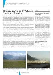
Rubriken/Rubriques - Geomatik Schweiz
Rubriken/Rubriques - Geomatik Schweiz
Rubriken/Rubriques - Geomatik Schweiz

Sie wollen auch ein ePaper? Erhöhen Sie die Reichweite Ihrer Titel.
YUMPU macht aus Druck-PDFs automatisch weboptimierte ePaper, die Google liebt.
Nouvelles des firmes<br />
Luftbild-Kammern gleich mehrere<br />
Vorteile. Sie erfasst gleichzeitig<br />
die drei Farbkanäle Rot-Grün-<br />
Blau und nahes Infrarot sowie<br />
drei panchromatische Kanäle für<br />
stereoskopische Auswertungen.<br />
Der Luftbild-Laserscanner Leica<br />
ALS40 ist ein luftgestützter LIDAR<br />
(Light Detection And Ranging).<br />
Vom Sensor ausgesandte Laser-<br />
Impulse werden auf der Erdoberfläche<br />
reflektiert. Dadurch gewinnt<br />
man auf effiziente Weise<br />
grosse Mengen an hochpräzisen<br />
XYZ-Koordinaten.<br />
David DeLorme, CEO und Firmengründer<br />
der DeLorme Publishing:<br />
«Im Vordergrund unserer<br />
Entscheidung stand die Zielsetzung,<br />
dass wir unsere Kunden mit<br />
erstklassigen Geodaten beliefern<br />
wollen, welche gleichzeitig sehr<br />
effizient produziert werden können.<br />
Eine neue Anwendung stellt<br />
das automatische Erfassen von linearen<br />
Strukturen in städtischen<br />
Agglomerationen dar.»<br />
Der TopoBird wird vor allem in US-<br />
Ballungsgebieten eingesetzt. Dabei<br />
handelt es sich um diejenigen<br />
zehn Prozent der Landesfläche,<br />
auf welcher 70% der Bevölkerung<br />
lebt. Die mit Leica ADS40<br />
und Leica ADL40 gewonnenen<br />
Cyra Technologies, Inc. (a Leica<br />
Geosystems company) announced<br />
a new release of its breakthrough<br />
Cyclone‘ CloudWorx‘ v2.0 for AutoCAD.<br />
The new software version<br />
further reduces the cost of creating<br />
accurate as-built drawings directly<br />
within AutoCAD applications<br />
when using rich, large 3D<br />
laser scan files. Based on the overwhelmingly<br />
favorable response to<br />
the initial CloudWorx v1.0 release,<br />
Cyra is now offering two versions<br />
of CloudWorx v2.0 for AutoCAD:<br />
«Basic» and «Pro».<br />
Automatic Piping As-builts<br />
CloudWorx Pro v2.0 enables users<br />
to automatically create accurate<br />
multispektralen Daten dienen dazu,<br />
die Qualität bestehender Produkte<br />
weiter zu verbessern – wie<br />
den «Street Atlas USA 2003»,<br />
«Topo USA 4.0» sowie die neue<br />
Software «Xmap 4.0».<br />
George Southard, von Leica Geosystems<br />
GIS & Kartierung (USA):<br />
«DeLorme hat die grossen Vorteile<br />
erkannt, die im kombinierten<br />
Einsatz von ADS40 und ALS40 liegen.<br />
So werden in einer Befliegung<br />
sowohl LIDAR-Daten als<br />
auch multispektrale Bilder gewonnen<br />
und dies mit einer<br />
Schwad-Breite, wie wir es von<br />
traditionellen Filmkameras gewohnt<br />
sind. DeLorme wird eine<br />
Menge Zeit und Geld sparen.»<br />
Auslieferung und Testflug waren<br />
für März 2003 vorgesehen. Seit<br />
der Auslieferung des ersten Leica<br />
ADS40-Systems vor einem guten<br />
Jahr wurden bis jetzt sieben solche<br />
digitale Luftbildsensoren verkauft.<br />
Leica Geosystems AG<br />
Heinrich-Wild-Strasse<br />
CH-9435 Heerbrugg<br />
Telefon 071 727 31 67<br />
marc.gimmel@<br />
gis.leica-geosystems.com<br />
www.gis.leica-geosystems.com<br />
Cyra Technologies Inc.: New CloudWorx<br />
v2.0 for AutoCAD Reduces Costs<br />
of As-builts from 3D Laser Scanning<br />
piping drawings and models directly<br />
in AutoCAD from point<br />
clouds captured by Cyrax ® 3D<br />
laser scanners. The user can model<br />
and represent piping as centerlines<br />
for routing and tie-point<br />
analyses, or as cylindrical surface<br />
models for clash detection. Piping<br />
as-builts can be created either by<br />
picking a point on a point cloud<br />
to automatically «region grow»<br />
(i.e. include neighboring points)<br />
or by creating a fence around a<br />
group of points and instructing<br />
the software to automatically create<br />
pipe. Segments of modeled<br />
piping can also be automatically<br />
extended and connected to intersect<br />
and create a piping run.<br />
Easier Point Cloud and «Slice»<br />
Management<br />
When creating as-builts from<br />
point clouds in AutoCAD, it is now<br />
much easier to work with individual<br />
point clouds and the cutplanes<br />
that users create when<br />
generating slices through point<br />
clouds. The ability to selectively<br />
load individual scans from different<br />
scanner positions, rather than<br />
to work with the full, complete<br />
set of registered scans, gives users<br />
control over the data set which is<br />
very helpful when extracting information<br />
and geometry from<br />
specific areas of a large scene for<br />
engineering, architecture, surveying<br />
and construction applications.<br />
CloudWorx v2.0 also lets users<br />
create and view point cloud<br />
slices/sections and save/restore<br />
them as needed. Users can now<br />
toggle back and forth between<br />
saved sections and simply recall<br />
the optimal section(s) for their<br />
work. In CloudWorx v1.0, only<br />
the last displayed section was<br />
saved.<br />
Finally, users can visualize 3D<br />
point clouds better in AutoCAD<br />
with CloudWorx v2.0’s brightness<br />
and color management controls.<br />
Previously, point clouds were<br />
sometimes difficult to visualize.<br />
CloudWorx v2.0 «Pro» and<br />
«Basic»<br />
The «Basic» module is intended<br />
for users who simply want to view<br />
point clouds and slices in Auto-<br />
StradaINFO © : GIS-basiertes<br />
Strassenschaden-Management<br />
CAD, plot them, and/or generate<br />
basic 2D planimetric and elevation<br />
drawings using existing CAD<br />
drafting tools. Accurate coordinate<br />
and distance measurements<br />
are made by snapping to individual<br />
points within point clouds.<br />
The «Pro» module includes all<br />
functionality of the Basic module,<br />
plus automatic pipe modeling and<br />
the ability to fully manage point<br />
clouds and 2D slices. CloudWorx<br />
Pro v2.0 is the ideal product for<br />
users to generate deliverables,<br />
such as plant models/drawings,<br />
most efficiently using a combination<br />
of CloudWorx and AutoCAD<br />
functionality.<br />
Availability<br />
The new Cyclone CloudWorx v2.0<br />
for AutoCAD «Basic» and «Pro»<br />
modules are available immediately.<br />
CloudWorx is compatible with<br />
popular AutoCAD-based piping<br />
design applications such as Auto-<br />
PLANT (Bentley/Rebis), CADWorx<br />
(Coade), and CADPIPE (AEC Design<br />
Group) as well as civil engineering<br />
applications such as Land<br />
Desktop (Autodesk). Pricing information<br />
is available through<br />
Cyra representatives.<br />
Leica Geosystems AG<br />
Kanalstrasse 21<br />
CH-8152 Glattbrugg<br />
Telefon 01 809 33 11<br />
Telefax 01 810 79 37<br />
info.swiss@leica-geosystems.com<br />
www.leica-geosystems.ch<br />
StradaINFO © ist ein einfach bedienbares<br />
Geoinformationssystem<br />
für das Management von<br />
Strassenschäden in Gemeinden.<br />
Das Programm unterstützt unter<br />
anderem die folgenden Verwaltungsaufgaben:<br />
Gesamtübersicht über den Zustand<br />
des Gemeindestrassennetzes.<br />
Optimierung der Werterhaltung.<br />
Planung, Kontrolle und laufende<br />
Anpassung der notwendigen<br />
Sanierungen.<br />
Systematische Finanzplanung<br />
und Kostenmanagement für<br />
den baulichen Unterhalt des<br />
Strassennetzes.<br />
Automatische Budgetabfrage<br />
für das festgelegte Unterhaltsprogramm,<br />
pro Jahr, pro Strasse<br />
oder pro Abschnitt.<br />
Was kann StradaINFO © ?<br />
Das Programm basiert auf den Ar-<br />
186<br />
Mensuration, Photogrammétrie, Génie rural 4/2003